Skamokawa, Washington | |
|---|---|
 | |
 Skamokawa | |
| Coordinates: 46°17′15″N 123°27′19″W / 46.28750°N 123.45528°W | |
| Country | United States |
| State | Washington |
| Counties | Wahkiakum County |
| Elevation | 30 ft (9 m) |
| Population (2007) | |
| • Total | 449 |
| Time zone | UTC-8 ( PST) |
| • Summer ( DST) | UTC-7 ( PDT) |
| ZIP codes | 98647 |
| Area code | Area code 360 |
| GNIS feature ID | 1508379 [1] |
Skamokawa ( /skʌˈmɑːkəˌweɪ/) is an unincorporated community in Wahkiakum County, Washington, United States. Skamokawa Valley, a census-designated place (CDP), lies directly to the north. Skamokawa is a Chinook term for smoke or fog on the water. [2]
Skamokawa rests on the banks of the Columbia River, and on WA 4. The town includes a post office, restaurant, and general store, along with a nearby historical museum and covered bridge. Originally focused on logging, is now a local center for kayaking and fishing.
-
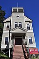
 Post Office
 -
-
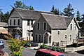 General Store
 -
 Donkey engine crew, c. 1918
 -
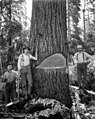 Felling men, c. 1918
 -
 Rafting logs, c. 1918
.jpg)
.jpg)
.jpg)
.jpeg)
.jpeg)
.jpeg)

- ^ "US Board on Geographic Names". United States Geological Survey. October 25, 2007. Retrieved January 31, 2008.
- ^ Majors, Harry M. (1975). Exploring Washington. Van Winkle Publishing Co. p. 114. ISBN 978-0-918664-00-6.
Municipalities and communities of
Wahkiakum County, Washington, United States | ||
|---|---|---|
| Town | 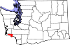 | |
| CDPs | ||
|
Other communities | ||
| International | |
|---|---|
| National | |
|
| This Wahkiakum County, Washington state location article is a stub. You can help Wikipedia by expanding it. |
Skamokawa, Washington | |
|---|---|
|
| |
Skamokawa | |
| Coordinates: 46°17′15″N 123°27′19″W / 46.28750°N 123.45528°W | |
| Country | United States |
| State | Washington |
| Counties | Wahkiakum County |
| Elevation | 30 ft (9 m) |
| Population (2007) | |
| • Total | 449 |
| Time zone | UTC-8 ( PST) |
| • Summer ( DST) | UTC-7 ( PDT) |
| ZIP codes | 98647 |
| Area code | Area code 360 |
| GNIS feature ID | 1508379 [1] |
Skamokawa ( /skʌˈmɑːkəˌweɪ/) is an unincorporated community in Wahkiakum County, Washington, United States. Skamokawa Valley, a census-designated place (CDP), lies directly to the north. Skamokawa is a Chinook term for smoke or fog on the water. [2]
Skamokawa rests on the banks of the Columbia River, and on WA 4. The town includes a post office, restaurant, and general store, along with a nearby historical museum and covered bridge. Originally focused on logging, is now a local center for kayaking and fishing.
-
Post Office
-
-
General Store
-
Donkey engine crew, c. 1918
-
Felling men, c. 1918
-
Rafting logs, c. 1918
- ^ "US Board on Geographic Names". United States Geological Survey. October 25, 2007. Retrieved January 31, 2008.
- ^ Majors, Harry M. (1975). Exploring Washington. Van Winkle Publishing Co. p. 114. ISBN 978-0-918664-00-6.
Municipalities and communities of
Wahkiakum County, Washington, United States | ||
|---|---|---|
| Town | | |
| CDPs | ||
|
Other communities | ||
| International | |
|---|---|
| National | |
|
| This Wahkiakum County, Washington state location article is a stub. You can help Wikipedia by expanding it. |