Photos • Location
Skaftárhreppur | |
|---|---|
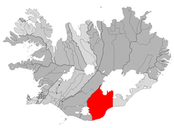
 Location of the municipality | |
| Coordinates: 63°47′20″N 18°03′14″W / 63.789°N 18.054°W | |
| Country | Iceland |
| Region | Southern Region |
| Constituency | South Constituency |
| Government | |
| • Manager | Eygló Kristjánsdóttir |
| Area | |
| • Total | 6,946 km2 (2,682 sq mi) |
| Population | |
| • Total | 452 |
| • Density | 0.07/km2 (0.2/sq mi) |
| Postal code(s) | 880 |
| Municipal number | 8509 |
| Website |
klaustur |
Skaftárhreppur (Icelandic pronunciation: [ˈskaftˌaur̥ˌr̥ɛhpʏr̥] ⓘ) is a municipality in southern Iceland. The largest settlement is Kirkjubæjarklaustur.
References
Skaftárhreppur | |
|---|---|
 Location of the municipality | |
| Coordinates: 63°47′20″N 18°03′14″W / 63.789°N 18.054°W | |
| Country | Iceland |
| Region | Southern Region |
| Constituency | South Constituency |
| Government | |
| • Manager | Eygló Kristjánsdóttir |
| Area | |
| • Total | 6,946 km2 (2,682 sq mi) |
| Population | |
| • Total | 452 |
| • Density | 0.07/km2 (0.2/sq mi) |
| Postal code(s) | 880 |
| Municipal number | 8509 |
| Website |
klaustur |
Skaftárhreppur (Icelandic pronunciation: [ˈskaftˌaur̥ˌr̥ɛhpʏr̥] ⓘ) is a municipality in southern Iceland. The largest settlement is Kirkjubæjarklaustur.
