Photos • Location
| Railway Station | |||||||||||
 | |||||||||||
| General information | |||||||||||
| Location | Ekeren, Antwerp, Belgium | ||||||||||
| Coordinates | 51°17′29″N 4°26′05″E / 51.29139°N 4.43472°E | ||||||||||
| Owned by | National Railway Company of Belgium | ||||||||||
| Line(s) | Line 12 | ||||||||||
| Platforms | 2 | ||||||||||
| Tracks | 2 | ||||||||||
| History | |||||||||||
| Opened | 1934 | ||||||||||
| Services | |||||||||||
| |||||||||||
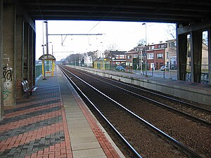
Sint-Mariaburg is a railway station in the town of Ekeren, Antwerp, Belgium. The station opened in 1934 on the Antwerp–Lage Zwaluwe railway, known in Belgium as Line 12.
The station is served by the following services:
- Local services (L-22) Roosendaal - Essen - Antwerp - Puurs (weekdays)
- Local services (L-22) Roosendaal - Essen - Antwerp (weekends)
| Railway Station | |||||||||||
 | |||||||||||
| General information | |||||||||||
| Location | Ekeren, Antwerp, Belgium | ||||||||||
| Coordinates | 51°17′29″N 4°26′05″E / 51.29139°N 4.43472°E | ||||||||||
| Owned by | National Railway Company of Belgium | ||||||||||
| Line(s) | Line 12 | ||||||||||
| Platforms | 2 | ||||||||||
| Tracks | 2 | ||||||||||
| History | |||||||||||
| Opened | 1934 | ||||||||||
| Services | |||||||||||
| |||||||||||
Sint-Mariaburg is a railway station in the town of Ekeren, Antwerp, Belgium. The station opened in 1934 on the Antwerp–Lage Zwaluwe railway, known in Belgium as Line 12.
The station is served by the following services:
- Local services (L-22) Roosendaal - Essen - Antwerp - Puurs (weekdays)
- Local services (L-22) Roosendaal - Essen - Antwerp (weekends)
