Photos • Location

Siler, Virginia | |
|---|---|
 Siler  Siler | |
| Coordinates: 39°21′2″N 78°14′20″W / 39.35056°N 78.23889°W | |
| Country | United States |
| State | Virginia |
| County | Frederick |
| Time zone | UTC−5 ( Eastern (EST)) |
| • Summer ( DST) | UTC−4 (EDT) |
| GNIS feature ID | 1477752 [1] |
Siler is an unincorporated community in Frederick County, Virginia, United States. Siler is located in northern Frederick County on Brush Creek at the crossroads of Brush Creek, Howards Chapel (VA 690), and Siler Roads.
References
Municipalities and communities of
Frederick County, Virginia, United States | ||
|---|---|---|
| Towns | 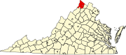 | |
| CDPs | ||
|
Other communities |
| |
This Frederick County, Virginia state location article is a stub. You can help Wikipedia by expanding it. |
Siler, Virginia | |
|---|---|
Siler Siler | |
| Coordinates: 39°21′2″N 78°14′20″W / 39.35056°N 78.23889°W | |
| Country | United States |
| State | Virginia |
| County | Frederick |
| Time zone | UTC−5 ( Eastern (EST)) |
| • Summer ( DST) | UTC−4 (EDT) |
| GNIS feature ID | 1477752 [1] |
Siler is an unincorporated community in Frederick County, Virginia, United States. Siler is located in northern Frederick County on Brush Creek at the crossroads of Brush Creek, Howards Chapel (VA 690), and Siler Roads.
References
Municipalities and communities of
Frederick County, Virginia, United States | ||
|---|---|---|
| Towns | | |
| CDPs | ||
|
Other communities |
| |
This Frederick County, Virginia state location article is a stub. You can help Wikipedia by expanding it. |