Deforested landscape in the Shan Hills near Kalaw during the dry season.Anishakan waterfall near
Pyin U Lwin.March 2011 earthquake location
The Shan Hills (
Burmese: ရှမ်းရိုးမ; Shan Yoma), also known as Shan Highland, is a vast
mountainous zone that extends through
Yunnan to
Myanmar and
Thailand. The whole region is made up of numerous peaks separated mostly by narrow valleys, as well as a few broader
intermontane basins. The ranges in the area are aligned in such a way that they link[clarification needed] to the
foothills of the
Himalayas further to the northwest.
The name of the massif or system of ranges, is derived from the
Shan State and its peoples, said in its turn to be derived from the word "
Siam",[4] that occupies most of the Shan Highland area.
Since it was relatively unexplored until recent times, the Shan mountainous region was referred to as the "Shan Plateau" in geographic works of the
British colonial period,[5][6] a name that is still sometimes used.[7] However, since the whole area lacks the expanses of relatively flat high terrain which are the main characteristic of a
plateau, this label is rather incongruous.[8]
Geology
Geologically in the Shan Hills and their southern subranges, layers of
alluvium are superimposed on hard rock.[9]Karstic ranges are common, for large tracts of the hills are
limestone. The Shan Hills are an important
silver and
ruby mining area.[citation needed]
Geography
The area of the Shan Highland is a combination of hill ranges, steep river valleys and a few elevated plains. The area is the primary source of Myanmar's
sapphires,
rubies and other
gems, for which the country is known; it is also a principal source of
lead,
silver and
zinc. The high plain averages about 1,000 metres (3,300 ft) in
elevation, and is sparsely populated.[10]
The Shan Hills straddle central eastern Myanmar and northwestern Thailand. They rise steeply from Myanmar's central plain and stretch for hundreds of kilometres eastwards into Thailand's northwest. The surface of the system is cut across by steep river gorges, part of the
drainage basins of the
Chao Phraya, the
Irrawaddy, the
Sittaung and the
Salween or Thanlwin River which cuts across the plateau in a north–south direction.[6]
Subranges
Daen Lao Range. The
Daen Lao Range (ทิวเขาแดนลาว) or 'Loi La Range' is in the southern and southeastern area of the Shan Hills. It separates the Salween watershed from the
Mekong watershed. The Daen Lao Mountain Range begins at
Chiang Saen in the east and
Doi Chiang Dao at 2,175 m (7,136 ft) is one of its highest points. The Daen Lao subrange includes
Doi Nang Non (The Sleeping Lady), a
karstic formation at its southern end with waterfalls and caves.[11]
Karen Hills. The west end of the Shan Hills system is not clearly defined, with the
Karen Hills in the southwestern area of the system beyond the Salween. Geographically the Karen Hills are the southwestern projection of the Shan Hills.[12] They are also referred to as "Kayah-Karen Mountains".[13]
Thanon Thong Chai Range. The
Thanon Thong Chai Range (เทือกเขาถนนธงชัย) is the southernmost prolongation of the Shan Highland system. Southwards from the Daen Lao Range a series of mountain ranges extend in near-parallel fashion above the Shan Plateau rising up to heights of 2,500 m (8,200 ft), with the
Dawna Range in the west reaching the beginning of the
Tenasserim Hills further south.
Doi Inthanon, the highest point in Thailand, reaching 2,565 m (8,415 ft), is part of the Inthanon Range (ทิวเขาอินทนนท์), a high ridge of the Thanon Thong Chai subrange located in
Chiang Mai Province. The highest point of the Thanon Thong Chai Range in neighboring
Mae Hong Son Province is
Doi Mae Ya (ยอดเขาแม่ยะ) at 2,005 m (6,578 ft), on the western side of these mountains in
Pai District.[14] Other high peaks of this range are
Doi Pui at 1,685 m (5,528 ft) and
Doi Suthep at 1,676 m (5,499 ft). Some geographers include the Thanon Thong Chai Range subsystem as part of the Daen Lao Range.[6]
History
In
British colonial times, the main hill station in
Burma,
Pyin Oo Lwin known in English as Maymyo, was built in the western region of the Shan Hills. At 1,000 metres (3,300 ft) above sea level and about one and a half hour drive from
Mandalay, it was one of the retreats for colonial officials escaping the heat of the Burmese summer. Pyin Oo Lwin is still known for its
botanical gardens and, like all British
hill stations, has samples of
colonial architecture. Presently
Inle Lake near
Yawnghwe is one of the tourist attractions of the Shan highlands.[15]
Owing to the insurgency and the activity of the
Tatmadaw in the area many local people living in the mountainous areas of the Shan Hills moved across the border to
Thailand where they live in
refugee camps.[17]
Despite the ongoing insurgency, the Shan Hills grows most of Myanmar's
potatoes.[18]
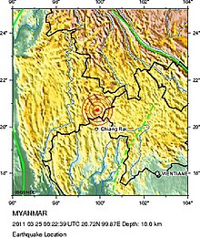
On 24 March 2011, a
magnitude 6.8 earthquake struck in Tarlay,
Tachileik Township, in the Daen Lao range area on the eastern part of the hill system. It killed more than 70 and injured more than 100 people. Three hundred-ninety houses, 14
Buddhist monasteries and nine government buildings were damaged.[19][20]
Features
Hilly landscape in
Kalaw area, Shan Hills, Myanmar
Deforested landscape in the Shan Hills near Kalaw during the dry season.Anishakan waterfall near
Pyin U Lwin.March 2011 earthquake location
The Shan Hills (
Burmese: ရှမ်းရိုးမ; Shan Yoma), also known as Shan Highland, is a vast
mountainous zone that extends through
Yunnan to
Myanmar and
Thailand. The whole region is made up of numerous peaks separated mostly by narrow valleys, as well as a few broader
intermontane basins. The ranges in the area are aligned in such a way that they link[clarification needed] to the
foothills of the
Himalayas further to the northwest.
The name of the massif or system of ranges, is derived from the
Shan State and its peoples, said in its turn to be derived from the word "
Siam",[4] that occupies most of the Shan Highland area.
Since it was relatively unexplored until recent times, the Shan mountainous region was referred to as the "Shan Plateau" in geographic works of the
British colonial period,[5][6] a name that is still sometimes used.[7] However, since the whole area lacks the expanses of relatively flat high terrain which are the main characteristic of a
plateau, this label is rather incongruous.[8]
Geology
Geologically in the Shan Hills and their southern subranges, layers of
alluvium are superimposed on hard rock.[9]Karstic ranges are common, for large tracts of the hills are
limestone. The Shan Hills are an important
silver and
ruby mining area.[citation needed]
Geography
The area of the Shan Highland is a combination of hill ranges, steep river valleys and a few elevated plains. The area is the primary source of Myanmar's
sapphires,
rubies and other
gems, for which the country is known; it is also a principal source of
lead,
silver and
zinc. The high plain averages about 1,000 metres (3,300 ft) in
elevation, and is sparsely populated.[10]
The Shan Hills straddle central eastern Myanmar and northwestern Thailand. They rise steeply from Myanmar's central plain and stretch for hundreds of kilometres eastwards into Thailand's northwest. The surface of the system is cut across by steep river gorges, part of the
drainage basins of the
Chao Phraya, the
Irrawaddy, the
Sittaung and the
Salween or Thanlwin River which cuts across the plateau in a north–south direction.[6]
Subranges
Daen Lao Range. The
Daen Lao Range (ทิวเขาแดนลาว) or 'Loi La Range' is in the southern and southeastern area of the Shan Hills. It separates the Salween watershed from the
Mekong watershed. The Daen Lao Mountain Range begins at
Chiang Saen in the east and
Doi Chiang Dao at 2,175 m (7,136 ft) is one of its highest points. The Daen Lao subrange includes
Doi Nang Non (The Sleeping Lady), a
karstic formation at its southern end with waterfalls and caves.[11]
Karen Hills. The west end of the Shan Hills system is not clearly defined, with the
Karen Hills in the southwestern area of the system beyond the Salween. Geographically the Karen Hills are the southwestern projection of the Shan Hills.[12] They are also referred to as "Kayah-Karen Mountains".[13]
Thanon Thong Chai Range. The
Thanon Thong Chai Range (เทือกเขาถนนธงชัย) is the southernmost prolongation of the Shan Highland system. Southwards from the Daen Lao Range a series of mountain ranges extend in near-parallel fashion above the Shan Plateau rising up to heights of 2,500 m (8,200 ft), with the
Dawna Range in the west reaching the beginning of the
Tenasserim Hills further south.
Doi Inthanon, the highest point in Thailand, reaching 2,565 m (8,415 ft), is part of the Inthanon Range (ทิวเขาอินทนนท์), a high ridge of the Thanon Thong Chai subrange located in
Chiang Mai Province. The highest point of the Thanon Thong Chai Range in neighboring
Mae Hong Son Province is
Doi Mae Ya (ยอดเขาแม่ยะ) at 2,005 m (6,578 ft), on the western side of these mountains in
Pai District.[14] Other high peaks of this range are
Doi Pui at 1,685 m (5,528 ft) and
Doi Suthep at 1,676 m (5,499 ft). Some geographers include the Thanon Thong Chai Range subsystem as part of the Daen Lao Range.[6]
History
In
British colonial times, the main hill station in
Burma,
Pyin Oo Lwin known in English as Maymyo, was built in the western region of the Shan Hills. At 1,000 metres (3,300 ft) above sea level and about one and a half hour drive from
Mandalay, it was one of the retreats for colonial officials escaping the heat of the Burmese summer. Pyin Oo Lwin is still known for its
botanical gardens and, like all British
hill stations, has samples of
colonial architecture. Presently
Inle Lake near
Yawnghwe is one of the tourist attractions of the Shan highlands.[15]
Owing to the insurgency and the activity of the
Tatmadaw in the area many local people living in the mountainous areas of the Shan Hills moved across the border to
Thailand where they live in
refugee camps.[17]
Despite the ongoing insurgency, the Shan Hills grows most of Myanmar's
potatoes.[18]
On 24 March 2011, a
magnitude 6.8 earthquake struck in Tarlay,
Tachileik Township, in the Daen Lao range area on the eastern part of the hill system. It killed more than 70 and injured more than 100 people. Three hundred-ninety houses, 14
Buddhist monasteries and nine government buildings were damaged.[19][20]
Features
Hilly landscape in
Kalaw area, Shan Hills, Myanmar
 Hilly landscape in Kalaw area, Shan Hills, Myanmar
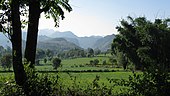
 The Shan Hills as seen from Inle Lake
 The Shan Hills in Mae Hong Son Province
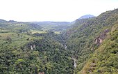 View over the Gokteik Gorge between Hsipaw and Pyin U Lwin
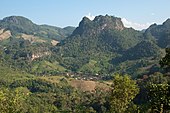 The Shan Hills between Chiang Mai and the border with Myanmar


.jpg)


