Sde Nitzan
שְׂדֵה נִצָּן, שדה ניצן سدي نيتسان | |
|---|---|

Pitaya fruits in Sde Nitzan | |
| Etymology: Field of (Flower) Buds | |
| Coordinates: 31°13′45″N 34°25′12″E / 31.22917°N 34.42000°E | |
| Country | Israel |
| District | Southern |
| Council | Eshkol |
| Affiliation | Moshavim Movement |
| Founded | 1973 |
| Founded by | English-speaking immigrants |
| Population (2022) | 393 [1] |
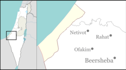
Sde Nitzan ( Hebrew: שְׂדֵה נִצָּן, lit. Field of (Flower) Buds) is a moshav in the northern Negev desert in Israel. Located twelve kilometres east of Kerem Shalom and near Beersheba, it falls under the jurisdiction of Eshkol Regional Council. In 2022 it had a population of 393. [1]
The moshav was established in 1973 by immigrants from English speaking countries, [2] with the name being an approximate translation of the name of a Jewish philanthropist named Bloomfield ("Field of Flowers").
- ^ a b "Regional Statistics". Israel Central Bureau of Statistics. Retrieved 21 March 2024.
- ^ El'azari, Yuval, ed. (2005). Mapa's concise gazetteer of Israel (in Hebrew). Tel-Aviv: Mapa Publishing. p. 525. ISBN 965-7184-34-7.
Sde Nitzan
שְׂדֵה נִצָּן, שדה ניצן سدي نيتسان | |
|---|---|

Pitaya fruits in Sde Nitzan | |
| Etymology: Field of (Flower) Buds | |
| Coordinates: 31°13′45″N 34°25′12″E / 31.22917°N 34.42000°E | |
| Country | Israel |
| District | Southern |
| Council | Eshkol |
| Affiliation | Moshavim Movement |
| Founded | 1973 |
| Founded by | English-speaking immigrants |
| Population (2022) | 393 [1] |
Sde Nitzan ( Hebrew: שְׂדֵה נִצָּן, lit. Field of (Flower) Buds) is a moshav in the northern Negev desert in Israel. Located twelve kilometres east of Kerem Shalom and near Beersheba, it falls under the jurisdiction of Eshkol Regional Council. In 2022 it had a population of 393. [1]
The moshav was established in 1973 by immigrants from English speaking countries, [2] with the name being an approximate translation of the name of a Jewish philanthropist named Bloomfield ("Field of Flowers").
- ^ a b "Regional Statistics". Israel Central Bureau of Statistics. Retrieved 21 March 2024.
- ^ El'azari, Yuval, ed. (2005). Mapa's concise gazetteer of Israel (in Hebrew). Tel-Aviv: Mapa Publishing. p. 525. ISBN 965-7184-34-7.
