Photos • Location
You can help expand this article with text translated from
the corresponding article in German. (September 2011) Click [show] for important translation instructions.
|
| Schwarzlofer | |
|---|---|
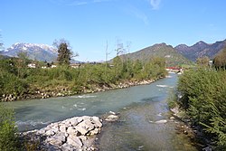
 Mouth of the Schwarzlofer (from bottom right) into the
Großache (from bottom left to top right), in the background the
Kaiser Mountains | |
| Location | |
| Countries | Austria and Germany |
| States | Tyrol and Bavaria |
| Physical characteristics | |
| Mouth | |
• location | Großache |
• coordinates | 47°39′43″N 12°25′14″E / 47.6619°N 12.4205°E |
| Length | 16.2 km (10.1 mi) [1] |
| Basin features | |
| Progression | Großache→ Alz→ Inn→ Danube→ Black Sea |
Schwarzlofer is a river of Tyrol, Austria and Bavaria, Germany. Its source is on the Schwarzlofer alm, north of Waidring (Tyrol). It passes through Reit im Winkl (Bavaria) and flows into the Großache near Kössen (Tyrol).
See also
References
- ^ Complete table of the Bavarian Waterbody Register by the Bavarian State Office for the Environment (xls, 10.3 MB)
You can help expand this article with text translated from
the corresponding article in German. (September 2011) Click [show] for important translation instructions.
|
| Schwarzlofer | |
|---|---|
 Mouth of the Schwarzlofer (from bottom right) into the
Großache (from bottom left to top right), in the background the
Kaiser Mountains | |
| Location | |
| Countries | Austria and Germany |
| States | Tyrol and Bavaria |
| Physical characteristics | |
| Mouth | |
• location | Großache |
• coordinates | 47°39′43″N 12°25′14″E / 47.6619°N 12.4205°E |
| Length | 16.2 km (10.1 mi) [1] |
| Basin features | |
| Progression | Großache→ Alz→ Inn→ Danube→ Black Sea |
Schwarzlofer is a river of Tyrol, Austria and Bavaria, Germany. Its source is on the Schwarzlofer alm, north of Waidring (Tyrol). It passes through Reit im Winkl (Bavaria) and flows into the Großache near Kössen (Tyrol).
See also
References
- ^ Complete table of the Bavarian Waterbody Register by the Bavarian State Office for the Environment (xls, 10.3 MB)