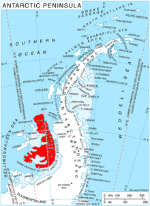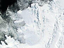

Satovcha Peak ( Bulgarian: връх Сатовча, romanized: vrah Satovcha, IPA: [ˈvrɤx sɐˈtɔft͡ʃɐ]) is the mostly ice-covered peak rising to 1587 m [1] in Havre Mountains, northern Alexander Island in Antarctica. It surmounts Bongrain Ice Piedmont to the northeast and Lennon Glacier to the southwest. Its south slopes are precipitous and partly ice-free. The vicinity was visited on 4 January 1988 by the geological survey party of Christo Pimpirev and Borislav Kamenov (First Bulgarian Antarctic Expedition), and Philip Nell and Peter Marquis ( British Antarctic Survey).
The feature is named after the settlement of Satovcha in Southwestern Bulgaria.
Location
The peak is located at 69°09′27″S 71°46′52″W / 69.15750°S 71.78111°W, which is 14.88 km east-southeast of Cape Vostok, 5.6 km south-southeast of Boyn Ridge, 13.23 km west by north of Mount Newman, 7.73 km northwest of Igralishte Peak and 6.54 km northeast of Nicolai Peak.
Maps
- British Antarctic Territory. Scale 1:200000 topographic map. DOS 610 – W 69 70. Tolworth, UK, 1971
- Antarctic Digital Database (ADD). Scale 1:250000 topographic map of Antarctica. Scientific Committee on Antarctic Research (SCAR). Since 1993, regularly upgraded and updated
Notes
- ^ Reference Elevation Model of Antarctica. Polar Geospatial Center. University of Minnesota, 2019
References
- Bulgarian Antarctic Gazetteer. Antarctic Place-names Commission. (details in Bulgarian, basic data in English)
- Satovcha Peak. SCAR Composite Gazetteer of Antarctica
External links
- Satovcha Peak. Copernix satellite image
This article includes information from the Antarctic Place-names Commission of Bulgaria which is used with permission.