Sarrin
صرين | |
|---|---|
Town | |
 Sarrin | |
| Coordinates: 36°35′15″N 38°17′59″E / 36.58750°N 38.29972°E | |
| Country | |
| Governorate | Aleppo |
| District | Ayn al-Arab |
| Subdistrict | Sarrin |
| Elevation | 356 m (1,168 ft) |
| Population (2004 census) | |
| • Total | 6,104 [1] |
| • Subdistrict | 70,522 |
| Time zone | UTC+2 ( EET) |
| • Summer ( DST) | UTC+3 ( EEST) |
| P-Code | C2074 |
| Geocode | SY020602 |
Sarrin ( Arabic: صرين, [2] also spelled Serrin or Sareen) is a town in northern Syria, administratively part of the Aleppo Governorate, located northeast of Aleppo. It is situated 3 kilometers east of the Euphrates River, south of Kobanî and east of Manbij. [3]

In the 2004 census, the town of Sarrin had a population of 6,140, while the Sarrin subdistrict had a total population of 70,522 mostly Arab. [1]
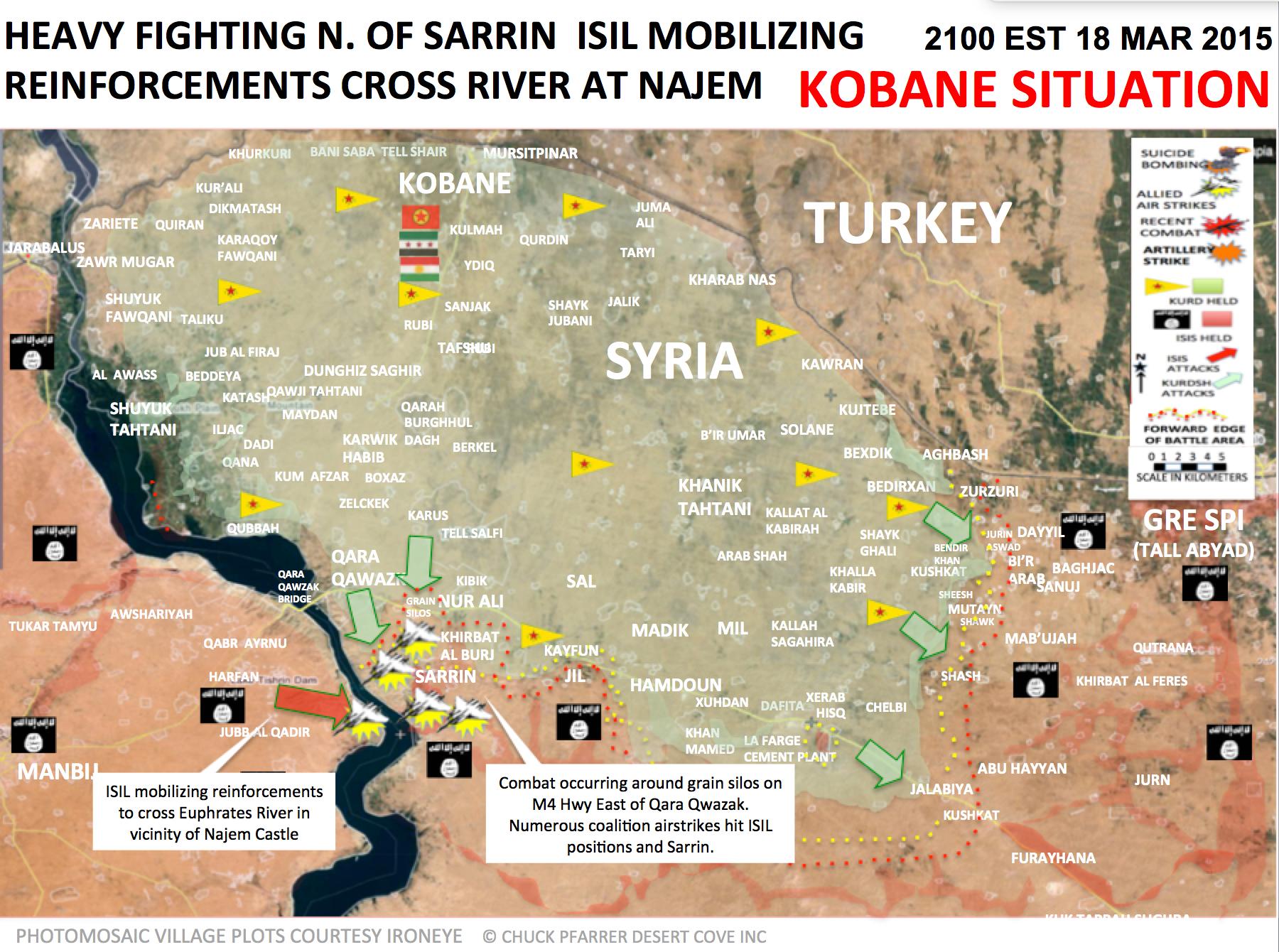
During the Syrian Civil War, the Islamic State of Iraq and the Levant seized control of the town in September 2013. [4] In March 2015, Kurds from the People's Protection Units (YPG), alongside Free Syrian Army (FSA) rebels, launched an attack to take control of the strategic town. [5] [6] On July 27, 2015, the town came under the control of Kurdish YPG forces. [7] [8]
See also
References
- ^ a b "2004 Census Data for Sarrin nahiyah" (in Arabic). Syrian Central Bureau of Statistics. Retrieved 15 October 2015. Also available in English: "2004 Census Data". UN OCHA. Retrieved 15 October 2015.
- ^ "Polat Can". Twitter. Retrieved 27 July 2015.
- ^ "Google Maps". Retrieved 1 April 2015.
- ^ Ashkenas, Jeremy; Tse, Archie; Watkins, Derek; Yourish, Karen (July 3, 2014). "A Rogue State Along Two Rivers" – via NYTimes.com.
- ^ "Syrian Kurds, rebels find common enemy in ISIS - Al-Monitor: the Pulse of the Middle East". Al-Monitor. Archived from the original on 28 March 2014. Retrieved 1 April 2015.
- ^ https://pbs.twimg.com/media/CAa__0sUkAA1ffv.jpg:large [ bare URL image file]
- ^ "Kurds cut key IS supply route in northern Syria: monitor". France 24. July 27, 2015. Archived from the original on September 24, 2015. Retrieved July 27, 2015.
- ^ "Syrian Kurds capture town from ISIS in north: activists". The Daily Star. Retrieved 27 July 2015.
|
| This article about a location in Aleppo Governorate, Syria is a stub. You can help Wikipedia by expanding it. |
Sarrin
صرين | |
|---|---|
Town | |
Sarrin | |
| Coordinates: 36°35′15″N 38°17′59″E / 36.58750°N 38.29972°E | |
| Country | |
| Governorate | Aleppo |
| District | Ayn al-Arab |
| Subdistrict | Sarrin |
| Elevation | 356 m (1,168 ft) |
| Population (2004 census) | |
| • Total | 6,104 [1] |
| • Subdistrict | 70,522 |
| Time zone | UTC+2 ( EET) |
| • Summer ( DST) | UTC+3 ( EEST) |
| P-Code | C2074 |
| Geocode | SY020602 |
Sarrin ( Arabic: صرين, [2] also spelled Serrin or Sareen) is a town in northern Syria, administratively part of the Aleppo Governorate, located northeast of Aleppo. It is situated 3 kilometers east of the Euphrates River, south of Kobanî and east of Manbij. [3]
In the 2004 census, the town of Sarrin had a population of 6,140, while the Sarrin subdistrict had a total population of 70,522 mostly Arab. [1]
During the Syrian Civil War, the Islamic State of Iraq and the Levant seized control of the town in September 2013. [4] In March 2015, Kurds from the People's Protection Units (YPG), alongside Free Syrian Army (FSA) rebels, launched an attack to take control of the strategic town. [5] [6] On July 27, 2015, the town came under the control of Kurdish YPG forces. [7] [8]
See also
References
- ^ a b "2004 Census Data for Sarrin nahiyah" (in Arabic). Syrian Central Bureau of Statistics. Retrieved 15 October 2015. Also available in English: "2004 Census Data". UN OCHA. Retrieved 15 October 2015.
- ^ "Polat Can". Twitter. Retrieved 27 July 2015.
- ^ "Google Maps". Retrieved 1 April 2015.
- ^ Ashkenas, Jeremy; Tse, Archie; Watkins, Derek; Yourish, Karen (July 3, 2014). "A Rogue State Along Two Rivers" – via NYTimes.com.
- ^ "Syrian Kurds, rebels find common enemy in ISIS - Al-Monitor: the Pulse of the Middle East". Al-Monitor. Archived from the original on 28 March 2014. Retrieved 1 April 2015.
- ^ https://pbs.twimg.com/media/CAa__0sUkAA1ffv.jpg:large [ bare URL image file]
- ^ "Kurds cut key IS supply route in northern Syria: monitor". France 24. July 27, 2015. Archived from the original on September 24, 2015. Retrieved July 27, 2015.
- ^ "Syrian Kurds capture town from ISIS in north: activists". The Daily Star. Retrieved 27 July 2015.
Capital:
Aleppo | ||||||||||||||||||||
|   | |||||||||||||||||||
|
| ||||||||||||||||||||
| ||||||||||||||||||||
| ||||||||||||||||||||
| ||||||||||||||||||||
| ||||||||||||||||||||
| ||||||||||||||||||||
| ||||||||||||||||||||
| ||||||||||||||||||||
|
| This article about a location in Aleppo Governorate, Syria is a stub. You can help Wikipedia by expanding it. |