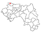
Photos • Location
Saréboido | |
|---|---|
Sub-prefecture and town | |
| Coordinates: 12°24′N 13°32′W / 12.400°N 13.533°W | |
| Country | |
| Region | Boké Region |
| Prefecture | Koundara Prefecture |
| Population (2014) | |
| • Total | 33,700 |
| Time zone | UTC+0 ( GMT) |
Saréboido is a town and sub-prefecture in the Koundara Prefecture in the Boké Region of northern Guinea, near the border of Guinea-Bissau. [1] As of 2014 it had a population of 33,700 people. [2]
References
- ^ "Subprefectures of Guinea". Statoids. Retrieved April 19, 2009.
- ^ "Guinea". Institut National de la Statistique, Guinea, accessed via Geohive. Retrieved 27 August 2014.
12°24′N 13°32′W / 12.400°N 13.533°W

