This article has multiple issues. Please help
improve it or discuss these issues on the
talk page. (
Learn how and when to remove these template messages)
|
Sapahar Upazila
সাপাহার | |
|---|---|
 View of Sapahar town | |
.svg) | |
| Coordinates: 25°7.5′N 88°34.9′E / 25.1250°N 88.5817°E | |
| Country | |
| Division | Rajshahi |
| District | Naogaon |
| Government | |
| • Chairman | Shahjahan Mandal |
| Area | |
| • Upazila | 244.48 km2 (94.39 sq mi) |
| • Metro | 8.3 km2 (3.2 sq mi) |
| Population (2011 census) | |
| • Upazila | 161,792 |
| • Density | 660/km2 (1,700/sq mi) |
| Time zone | UTC+6 ( BST) |
| Postal code | 6560 |
| Website | Official Map of Sapahar |
Sapahar ( Bengali: সাপাহার) is an upazila of Naogaon District [1] in the Division of Rajshahi, Bangladesh.
_Bangladesh.svg)
Sapahar is located at 25.1250°N 88.5819°E. It has 36,232 house holds and total area 244.48 km2.
Sapahar Upazila is bounded by Tapan CD Block in Dakshin Dinajpur district, West Bengal, India, on the north, Patnitala Upazila on the east, Porsha Upazila on the south, and Bamangola CD Block, in Malda district, West Bengal, on the west. [1] [2] [3] Main river Punarbhaba at Patari village and Jabai Beel are notable.
According to the 2011 Bangladesh census, Sapahar Upazila had 36,232 households and a population of 161,792. 34,245 (21.17%) were under 10 years of age. Sapahar had a literacy rate (age 7 and over) of 42.19%, compared to the national average of 51.8%, and a sex ratio of 990 females per 1000 males. 12,696 (7.85%) lived in urban areas. [4] Ethnic population was 5,520 (3.41%), of which Santal were 1,851, Oraon 1,568 and Barman 796. [5]
Most of the people of the Sapahar Upazila depends on agriculture for a living. The main corps are mango, paddy, wheat, mustard, and vegetables. [1]
- Jobay Beel
Sapahar Thana was formed in 1979. It was turned into an upazila in 1985. [1]
The Upazila is divided into six union parishads: Aihai, Goala, Pathari, Sapahar, Shiranti, and Tilna. The union parishads are subdivided into 151 mauzas and 232 villages. [4]
Sapahar Sadar Town covers an area of 8.4 square kilometres (3.2 sq mi). [1] The town area consists of ward no. 1, 2, 4 and partially 3. According to the census of 2011, It has a population of 12696. About 2924 households are situated here.[ citation needed]
Tertiary educational institutions in Sapahar include:
- Sapahar Government College
- Chowdhury Chan Mohammad Women College
- Bhioil Degree College
- Tilna Degree College
- Dighirhat Degree College
- Sapahar Technical And Business Management College
- Al-Helal Islami Academy & College, Sapahar, Naogaon
- Sapahar Pilot High School, Naogaon
- Sapahar Govt. Girls High School
- Zaman Nagor Girls High School
- Dangapara High School
- Shironty Moinakuri High School
- Tilna ML High School
- Tilna Girls High School
- Jobay High School
- Aihai High School
- Tiloni-Patari High School
- Mirapara High School
- Bhioil High School
- Kalmudanga High School
- Goala High School
- Nischinta Pur High School
- Khottapara High School
- Koch Kurulia High School
- Teghoria B.L High School
- Tatoir Bakharpur High School
- Asharanda High School
- Chalkgopal High School
-
 জিরো পয়েন্ট
 -
 Public Library
 -
 Academic Building
 -
 Town area
 -
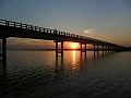 Jobay Bridge
 -
 Upazila Chattar Shaheed Minar
 -
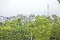 Sapahar Town
 -
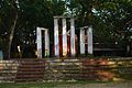
 Central Liberation War Monument


- ^ a b c d e Md. Mukhlesur Rahman (2012). "Sapahar Upazila". In Sirajul Islam and Ahmed A. Jamal (ed.). Banglapedia: National Encyclopedia of Bangladesh (Second ed.). Asiatic Society of Bangladesh.
- ^ "Tehsil Map of Dakshin Dinajpur". CD Block/ Tehsil. Maps of India. Retrieved 15 November 2018.
- ^ "Tehsil Map of Maldah". CD Block/ Tehsil. Maps of India. Retrieved 15 November 2018.
- ^ a b c "Bangladesh Population and Housing Census 2011 Zila Report – Naogaon" (PDF). bbs.gov.bd. Bangladesh Bureau of Statistics.
- ^ "Community Tables: Naogaon district" (PDF). bbs.gov.bd. Bangladesh Bureau of Statistics. 2011.
Capital:
Naogaon | ||
| Upazilas | ||
| Constituencies | ||
| Attractions and sites | ||
| History | ||
| Inhabited areas | ||
| Rivers and transport | ||
| Educational institutions |
| |

This article has multiple issues. Please help
improve it or discuss these issues on the
talk page. (
Learn how and when to remove these template messages)
|
Sapahar Upazila
সাপাহার | |
|---|---|
|
View of Sapahar town | |
|
| |
| Coordinates: 25°7.5′N 88°34.9′E / 25.1250°N 88.5817°E | |
| Country | |
| Division | Rajshahi |
| District | Naogaon |
| Government | |
| • Chairman | Shahjahan Mandal |
| Area | |
| • Upazila | 244.48 km2 (94.39 sq mi) |
| • Metro | 8.3 km2 (3.2 sq mi) |
| Population (2011 census) | |
| • Upazila | 161,792 |
| • Density | 660/km2 (1,700/sq mi) |
| Time zone | UTC+6 ( BST) |
| Postal code | 6560 |
| Website | Official Map of Sapahar |
Sapahar ( Bengali: সাপাহার) is an upazila of Naogaon District [1] in the Division of Rajshahi, Bangladesh.
Sapahar is located at 25.1250°N 88.5819°E. It has 36,232 house holds and total area 244.48 km2.
Sapahar Upazila is bounded by Tapan CD Block in Dakshin Dinajpur district, West Bengal, India, on the north, Patnitala Upazila on the east, Porsha Upazila on the south, and Bamangola CD Block, in Malda district, West Bengal, on the west. [1] [2] [3] Main river Punarbhaba at Patari village and Jabai Beel are notable.
According to the 2011 Bangladesh census, Sapahar Upazila had 36,232 households and a population of 161,792. 34,245 (21.17%) were under 10 years of age. Sapahar had a literacy rate (age 7 and over) of 42.19%, compared to the national average of 51.8%, and a sex ratio of 990 females per 1000 males. 12,696 (7.85%) lived in urban areas. [4] Ethnic population was 5,520 (3.41%), of which Santal were 1,851, Oraon 1,568 and Barman 796. [5]
Most of the people of the Sapahar Upazila depends on agriculture for a living. The main corps are mango, paddy, wheat, mustard, and vegetables. [1]
- Jobay Beel
Sapahar Thana was formed in 1979. It was turned into an upazila in 1985. [1]
The Upazila is divided into six union parishads: Aihai, Goala, Pathari, Sapahar, Shiranti, and Tilna. The union parishads are subdivided into 151 mauzas and 232 villages. [4]
Sapahar Sadar Town covers an area of 8.4 square kilometres (3.2 sq mi). [1] The town area consists of ward no. 1, 2, 4 and partially 3. According to the census of 2011, It has a population of 12696. About 2924 households are situated here.[ citation needed]
Tertiary educational institutions in Sapahar include:
- Sapahar Government College
- Chowdhury Chan Mohammad Women College
- Bhioil Degree College
- Tilna Degree College
- Dighirhat Degree College
- Sapahar Technical And Business Management College
- Al-Helal Islami Academy & College, Sapahar, Naogaon
- Sapahar Pilot High School, Naogaon
- Sapahar Govt. Girls High School
- Zaman Nagor Girls High School
- Dangapara High School
- Shironty Moinakuri High School
- Tilna ML High School
- Tilna Girls High School
- Jobay High School
- Aihai High School
- Tiloni-Patari High School
- Mirapara High School
- Bhioil High School
- Kalmudanga High School
- Goala High School
- Nischinta Pur High School
- Khottapara High School
- Koch Kurulia High School
- Teghoria B.L High School
- Tatoir Bakharpur High School
- Asharanda High School
- Chalkgopal High School
-
জিরো পয়েন্ট
-
Public Library
-
Academic Building
-
Town area
-
Jobay Bridge
-
Upazila Chattar Shaheed Minar
-
Sapahar Town
-
Central Liberation War Monument
- ^ a b c d e Md. Mukhlesur Rahman (2012). "Sapahar Upazila". In Sirajul Islam and Ahmed A. Jamal (ed.). Banglapedia: National Encyclopedia of Bangladesh (Second ed.). Asiatic Society of Bangladesh.
- ^ "Tehsil Map of Dakshin Dinajpur". CD Block/ Tehsil. Maps of India. Retrieved 15 November 2018.
- ^ "Tehsil Map of Maldah". CD Block/ Tehsil. Maps of India. Retrieved 15 November 2018.
- ^ a b c "Bangladesh Population and Housing Census 2011 Zila Report – Naogaon" (PDF). bbs.gov.bd. Bangladesh Bureau of Statistics.
- ^ "Community Tables: Naogaon district" (PDF). bbs.gov.bd. Bangladesh Bureau of Statistics. 2011.
Capital:
Naogaon | ||
| Upazilas | ||
| Constituencies | ||
| Attractions and sites | ||
| History | ||
| Inhabited areas | ||
| Rivers and transport | ||
| Educational institutions |
| |