.png)
.png)
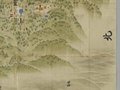
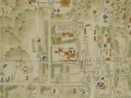
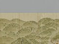
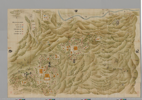
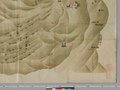
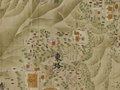
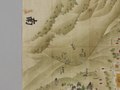
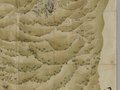
Sanmon-Santō Sakamoto Sōezu ( Japanese: 山門三塔坂本惣絵図, The Whole Maps of the three Areas of Enryakuji Temple on Mount Hiei and the Area of Sakamoto) is the two old maps that shows the precincts of Enryakuji Temple ( Japanese: 延暦寺, Hepburn: Enryakuji) on Mount Hiei ( Japanese: 比叡山, Hepburn: Hieizan) and Sakamoto area ( Japanese: 坂本, Hepburn: Sakamoto) at the foot of Mount Hiei, Otsu City, Shiga Prefecture, Japan. The maps was made in 1767 [1] [2] (the middle of the Edo period, Japan). The author is unknown.
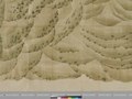
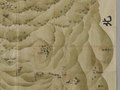
- The 1st volume of the maps shows Yokawa area (Hoku-tō area) ( Japanese: 横川地区 (北塔地区), The North Pagoda area) in the precincts of Enryakuji Temple on Mount Hiei and Sakamoto area at the foot of Mount Hiei.
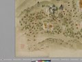
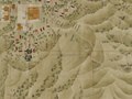
- The 2nd volume of the maps shows Tō-dō area ( Japanese: 東塔地区, The East Pagoda area) and Sai-tō area ( Japanese: 西塔地区, The West Pagoda area) in the precincts of Enryakuji Temple on Mount Hiei.
Meaning of the title
The meaning of the title, Sanmon-Santō Sakamoto Sōezu, is "the whole map of the three areas of Enryakuji Temple on Mount Hiei and the area of Sakamoto".
The meanings of the words that make up the title, Sanmon-Santō Sakamoto Sōezu, are as follows.
- The word "sanmon" ( Japanese: 山門) is another name of Enryakuji Temple on Mount Hiei.
- The word "santō" ( Japanese: 三塔) is a generic term used to refer to the three areas in the precincts of Enryakuji Temple: Tō-dō area ( Japanese: 東塔地区, The East Pagoda area), Sai-tō area ( Japanese: 西塔地区, The West Pagoda area), and Yokawa area (Hoku-tō area) ( Japanese: 横川地区 (北塔地区), The North Pagoda area).
- The word "Sakamoto" ( Japanese: 坂本) refers to the Sakamoto area at the eastern foot of Mount Hiei (present-day Sakamoto, Otsu City, Shiga Prefecture, Japan).
- The word "sō" ( Japanese: 惣) means "whole" or "all".
- The word "ezu" ( Japanese: 絵図) had used before the Meiji era ( Japanese: 明治時代) to mean what we call a "map" today.
As a historical document
Enryakuji Temple is registered as a UNESCO World Heritage Site as one of the 17 temples and shrines that make up the Historic Monuments of Ancient Kyoto (Kyoto, Uji and Otsu Cities). [3] [4] [5] [6] [7] In addition, Enryakuji Temple possesses several Japanese national treasures, including Konpon-chūdō ( Japanese: 根本中堂, The largest central main hall of Enryakuji Temple), and numerous Japanese important cultural properties. Therefore, Enryakuji Temple is a historically and culturally important place, and it once had possessed far more cultural properties and historical documents than are still in existence.
But the enormous cultural properties and historical documents of Enryakuji Temple suffered damage from the Siege of Mount Hiei in 1571 and much of these were lost. Currently, there are only a few historical documents that can tell us what the precincts of Enryakuji Temple in the past looked like.
Sanmon-Santō Sakamoto Sōezu is probably the most detailed pictorial old maps of the precincts of Enryakuji Temple in existence and also shows the halls of temples and shrines that may have existed before 1571. [8] Therefore, these maps are valuable historical documents to know about what the precincts in the past looked like.
Repository
Currently, these maps are one of the collections in the National Archives of Japan (NAJ). (These maps were formerly one of the collections in the Japanese Cabinet Library.)
Dimensions
- 1st volume size : Width 280cm x Height 187.5cm [9]
- 2nd volume size : Width 279cm x Height 187.5cm [9]
Notes
- ^ Take Kakuchō [in Japanese] (2008). Hieizan shodō shi no kenkyū ( Japanese: 比叡山諸堂史の研究, The Study of the History of the Halls of Enryakuji Temple on Mount Hiei). Hōzōkan ( Japanese: 法藏館). p. 116. ISBN 978-4-8318-7373-6.
- ^ Take Kakuchō [in Japanese] (1992). "Naikaku Bunko zou Sanmon-Santō Sakamoto Sōezu zen niyō no seiritsu ni tsuite ( Japanese: 内閣文庫蔵『山門三塔坂本惣絵図』全二葉の成立について, About the Formation of the two Maps, Sanmon-Santō Sakamoto Sōezu, in the Collection of Japanese Cabinet Library)". Eizan Gakuin kenkyū kiyō ( Japanese: 叡山学院研究紀要, Bulletin of Eizan Gakuin College (Annual of Buddhist studies)). 15. Eizan Gakuin ( Japanese: 叡山学院, Eizan Gakuin College (part of the Enryakuji Academy group)): 60–61. doi: 10.11501/4421875. ISSN 0389-2182.
- ^ Historic Monuments of Ancient Kyoto (Kyoto, Uji and Otsu Cities) - Maps - UNESCO World Heritage Centre
- ^ Enryakuji Temple | Shiga Attractions | Travel Japan | JNTO ( Japan National Tourism Organization)
- ^ World Heritage in Japan | Ministry of Foreign Affairs of Japan
- ^ Sekai-isan bunkazai online ( Japanese: 世界遺産 文化遺産オンライン, World Heritage Site | Japanese Cultural Heritage Online)
- ^ Kyōto-shi : Sekai-isan "Koto Kyōto no bunkazai (Kyōto-shi, Uji-shi, Ōtsu-shi)" ( Japanese: 京都市:世界遺産「古都京都の文化財(京都市・宇治市・大津市)」, Kyoto City | World Heritage Site "Historic Monuments of Ancient Kyoto (Kyoto, Uji and Otsu Cities)")
- ^ Take Kakuchō [in Japanese] (2008). Hieizan shodō shi no kenkyū ( Japanese: 比叡山諸堂史の研究, The Study of the History of the Halls of Enryakuji Temple on Mount Hiei). Hōzōkan ( Japanese: 法藏館). pp. 106–107. ISBN 978-4-8318-7373-6.
- ^ a b On April 13, 2021, contacted the NAJ and confirmed the size (width and length) of the 1st and 2nd maps.
References
- Take Kakuchō ( Japanese: 武覚超) (2008). Hieizan shodō shi no kenkyū ( Japanese: 比叡山諸堂史の研究, The Study of the History of the Halls of Enryakuji Temple on Mount Hiei). Hōzōkan ( Japanese: 法藏館). pp. 106–116. ISBN 978-4-8318-7373-6. id.ndl.go.jp/bib/000009432843.
- Take Kakuchō ( Japanese: 武覚超) (1992). "Naikaku Bunko zou Sanmon-Santō Sakamoto Sōezu zen niyō no seiritsu ni tsuite ( Japanese: 内閣文庫蔵『山門三塔坂本惣絵図』全二葉の成立について, About the Formation of the two Maps, Sanmon-Santō Sakamoto Sōezu, in the Collection of Japanese Cabinet Library)". Eizan Gakuin kenkyū kiyō ( Japanese: 叡山学院研究紀要, Bulletin of Eizan Gakuin College (Annual of Buddhist studies)). 15. Eizan Gakuin ( Japanese: 叡山学院, Eizan Gakuin College (part of the Enryakuji Academy group)): 51–120. doi: 10.11501/4421875. ISSN 0389-2182. id.ndl.go.jp/digimeta/4421875.
- Otsu City Museum of History ( Japanese: 大津市歴史博物館, Hepburn: Ōtsu-shi rekishi hakubutsukan), ed. (2000). Kochizu ga kataru Ōtsu no rekishi : Kaikan 10 shūnen, bunkazai hogohō 50 nen kinen ( Japanese: 古絵図が語る大津の歴史 : 開館10周年記念・文化財保護法50年記念, The History of Otsu City as Told by Old Drawings : 10th Anniversary of the Museum and 50th Anniversary of the Law for the Protection of Cultural Properties). Otsu City Museum of History ( Japanese: 大津市歴史博物館, Hepburn: Ōtsu-shi rekishi hakubutsukan). p. 53. id.ndl.go.jp/bib/000002972968.
External links
- 山門三塔坂本惣絵図 (Sanmon-Santō Sakamoto Sōezu ( Japanese: 山門三塔坂本惣絵図, The Whole Maps of the three Areas of Enryakuji Temple on Mount Hiei and the Area of Sakamoto))
See also
- Enryakuji Temple
- Mount Hiei
- Take Kakuchō (
Japanese:
武覚超)
- Ph.D. in Buddhist Studies and a Japanese Buddhist monk of the Tendai sect.
Image files
Sanmon-Santō Sakamoto Sōezu 1st volume
-
 Sanmon-Santō Sakamoto Sōezu 1st volume (Yokawa area in Enryakuji Temple on Mount Hiei and Sakamoto area)
JPEG (.jpg)
.jpg)
.jpg)
.jpg)
.jpg)
.jpg)
.jpg)
.jpg)
.jpg)
.jpg)
.jpg)
.jpg)
.jpg)
.jpg)
.jpg)
.jpg)
.jpg)
.jpg)
.jpg)
TIFF (.tif)


Sanmon-Santō Sakamoto Sōezu 2nd volume
-
 Sanmon-Santō Sakamoto Sōezu 2nd volume (Tō-dō area and Sai-tō area in Enryakuji Temple on Mount Hiei)
JPEG (.jpg)
.jpg)
.jpg)
.jpg)
.jpg)
.jpg)
.jpg)
.jpg)
.jpg)
.jpg)
.jpg)
.jpg)
.jpg)
.jpg)
.jpg)
.jpg)
.jpg)
.jpg)
.jpg)
TIFF (.tif)


.jpg)
.jpg)
.jpg)
.jpg)
.jpg)
.jpg)
.jpg)
.jpg)
.jpg)
.jpg)
.jpg)
.jpg)
.jpg)
.jpg)
.jpg)
.jpg)
.jpg)
.jpg)
.jpg)
.jpg)
.jpg)
.jpg)
.jpg)
.jpg)
.jpg)
.jpg)
.jpg)
.jpg)
.jpg)
.jpg)
.jpg)
.jpg)
.jpg)
.jpg)
.jpg)
.jpg)
Sanmon-Santō Sakamoto Sōezu ( Japanese: 山門三塔坂本惣絵図, The Whole Maps of the three Areas of Enryakuji Temple on Mount Hiei and the Area of Sakamoto) is the two old maps that shows the precincts of Enryakuji Temple ( Japanese: 延暦寺, Hepburn: Enryakuji) on Mount Hiei ( Japanese: 比叡山, Hepburn: Hieizan) and Sakamoto area ( Japanese: 坂本, Hepburn: Sakamoto) at the foot of Mount Hiei, Otsu City, Shiga Prefecture, Japan. The maps was made in 1767 [1] [2] (the middle of the Edo period, Japan). The author is unknown.
- The 1st volume of the maps shows Yokawa area (Hoku-tō area) ( Japanese: 横川地区 (北塔地区), The North Pagoda area) in the precincts of Enryakuji Temple on Mount Hiei and Sakamoto area at the foot of Mount Hiei.
- The 2nd volume of the maps shows Tō-dō area ( Japanese: 東塔地区, The East Pagoda area) and Sai-tō area ( Japanese: 西塔地区, The West Pagoda area) in the precincts of Enryakuji Temple on Mount Hiei.
Meaning of the title
The meaning of the title, Sanmon-Santō Sakamoto Sōezu, is "the whole map of the three areas of Enryakuji Temple on Mount Hiei and the area of Sakamoto".
The meanings of the words that make up the title, Sanmon-Santō Sakamoto Sōezu, are as follows.
- The word "sanmon" ( Japanese: 山門) is another name of Enryakuji Temple on Mount Hiei.
- The word "santō" ( Japanese: 三塔) is a generic term used to refer to the three areas in the precincts of Enryakuji Temple: Tō-dō area ( Japanese: 東塔地区, The East Pagoda area), Sai-tō area ( Japanese: 西塔地区, The West Pagoda area), and Yokawa area (Hoku-tō area) ( Japanese: 横川地区 (北塔地区), The North Pagoda area).
- The word "Sakamoto" ( Japanese: 坂本) refers to the Sakamoto area at the eastern foot of Mount Hiei (present-day Sakamoto, Otsu City, Shiga Prefecture, Japan).
- The word "sō" ( Japanese: 惣) means "whole" or "all".
- The word "ezu" ( Japanese: 絵図) had used before the Meiji era ( Japanese: 明治時代) to mean what we call a "map" today.
As a historical document
Enryakuji Temple is registered as a UNESCO World Heritage Site as one of the 17 temples and shrines that make up the Historic Monuments of Ancient Kyoto (Kyoto, Uji and Otsu Cities). [3] [4] [5] [6] [7] In addition, Enryakuji Temple possesses several Japanese national treasures, including Konpon-chūdō ( Japanese: 根本中堂, The largest central main hall of Enryakuji Temple), and numerous Japanese important cultural properties. Therefore, Enryakuji Temple is a historically and culturally important place, and it once had possessed far more cultural properties and historical documents than are still in existence.
But the enormous cultural properties and historical documents of Enryakuji Temple suffered damage from the Siege of Mount Hiei in 1571 and much of these were lost. Currently, there are only a few historical documents that can tell us what the precincts of Enryakuji Temple in the past looked like.
Sanmon-Santō Sakamoto Sōezu is probably the most detailed pictorial old maps of the precincts of Enryakuji Temple in existence and also shows the halls of temples and shrines that may have existed before 1571. [8] Therefore, these maps are valuable historical documents to know about what the precincts in the past looked like.
Repository
Currently, these maps are one of the collections in the National Archives of Japan (NAJ). (These maps were formerly one of the collections in the Japanese Cabinet Library.)
Dimensions
- 1st volume size : Width 280cm x Height 187.5cm [9]
- 2nd volume size : Width 279cm x Height 187.5cm [9]
Notes
- ^ Take Kakuchō [in Japanese] (2008). Hieizan shodō shi no kenkyū ( Japanese: 比叡山諸堂史の研究, The Study of the History of the Halls of Enryakuji Temple on Mount Hiei). Hōzōkan ( Japanese: 法藏館). p. 116. ISBN 978-4-8318-7373-6.
- ^ Take Kakuchō [in Japanese] (1992). "Naikaku Bunko zou Sanmon-Santō Sakamoto Sōezu zen niyō no seiritsu ni tsuite ( Japanese: 内閣文庫蔵『山門三塔坂本惣絵図』全二葉の成立について, About the Formation of the two Maps, Sanmon-Santō Sakamoto Sōezu, in the Collection of Japanese Cabinet Library)". Eizan Gakuin kenkyū kiyō ( Japanese: 叡山学院研究紀要, Bulletin of Eizan Gakuin College (Annual of Buddhist studies)). 15. Eizan Gakuin ( Japanese: 叡山学院, Eizan Gakuin College (part of the Enryakuji Academy group)): 60–61. doi: 10.11501/4421875. ISSN 0389-2182.
- ^ Historic Monuments of Ancient Kyoto (Kyoto, Uji and Otsu Cities) - Maps - UNESCO World Heritage Centre
- ^ Enryakuji Temple | Shiga Attractions | Travel Japan | JNTO ( Japan National Tourism Organization)
- ^ World Heritage in Japan | Ministry of Foreign Affairs of Japan
- ^ Sekai-isan bunkazai online ( Japanese: 世界遺産 文化遺産オンライン, World Heritage Site | Japanese Cultural Heritage Online)
- ^ Kyōto-shi : Sekai-isan "Koto Kyōto no bunkazai (Kyōto-shi, Uji-shi, Ōtsu-shi)" ( Japanese: 京都市:世界遺産「古都京都の文化財(京都市・宇治市・大津市)」, Kyoto City | World Heritage Site "Historic Monuments of Ancient Kyoto (Kyoto, Uji and Otsu Cities)")
- ^ Take Kakuchō [in Japanese] (2008). Hieizan shodō shi no kenkyū ( Japanese: 比叡山諸堂史の研究, The Study of the History of the Halls of Enryakuji Temple on Mount Hiei). Hōzōkan ( Japanese: 法藏館). pp. 106–107. ISBN 978-4-8318-7373-6.
- ^ a b On April 13, 2021, contacted the NAJ and confirmed the size (width and length) of the 1st and 2nd maps.
References
- Take Kakuchō ( Japanese: 武覚超) (2008). Hieizan shodō shi no kenkyū ( Japanese: 比叡山諸堂史の研究, The Study of the History of the Halls of Enryakuji Temple on Mount Hiei). Hōzōkan ( Japanese: 法藏館). pp. 106–116. ISBN 978-4-8318-7373-6. id.ndl.go.jp/bib/000009432843.
- Take Kakuchō ( Japanese: 武覚超) (1992). "Naikaku Bunko zou Sanmon-Santō Sakamoto Sōezu zen niyō no seiritsu ni tsuite ( Japanese: 内閣文庫蔵『山門三塔坂本惣絵図』全二葉の成立について, About the Formation of the two Maps, Sanmon-Santō Sakamoto Sōezu, in the Collection of Japanese Cabinet Library)". Eizan Gakuin kenkyū kiyō ( Japanese: 叡山学院研究紀要, Bulletin of Eizan Gakuin College (Annual of Buddhist studies)). 15. Eizan Gakuin ( Japanese: 叡山学院, Eizan Gakuin College (part of the Enryakuji Academy group)): 51–120. doi: 10.11501/4421875. ISSN 0389-2182. id.ndl.go.jp/digimeta/4421875.
- Otsu City Museum of History ( Japanese: 大津市歴史博物館, Hepburn: Ōtsu-shi rekishi hakubutsukan), ed. (2000). Kochizu ga kataru Ōtsu no rekishi : Kaikan 10 shūnen, bunkazai hogohō 50 nen kinen ( Japanese: 古絵図が語る大津の歴史 : 開館10周年記念・文化財保護法50年記念, The History of Otsu City as Told by Old Drawings : 10th Anniversary of the Museum and 50th Anniversary of the Law for the Protection of Cultural Properties). Otsu City Museum of History ( Japanese: 大津市歴史博物館, Hepburn: Ōtsu-shi rekishi hakubutsukan). p. 53. id.ndl.go.jp/bib/000002972968.
External links
- 山門三塔坂本惣絵図 (Sanmon-Santō Sakamoto Sōezu ( Japanese: 山門三塔坂本惣絵図, The Whole Maps of the three Areas of Enryakuji Temple on Mount Hiei and the Area of Sakamoto))
See also
- Enryakuji Temple
- Mount Hiei
- Take Kakuchō (
Japanese:
武覚超)
- Ph.D. in Buddhist Studies and a Japanese Buddhist monk of the Tendai sect.
Image files
Sanmon-Santō Sakamoto Sōezu 1st volume
-
Sanmon-Santō Sakamoto Sōezu 1st volume (Yokawa area in Enryakuji Temple on Mount Hiei and Sakamoto area)
JPEG (.jpg)
TIFF (.tif)
Sanmon-Santō Sakamoto Sōezu 2nd volume
-
Sanmon-Santō Sakamoto Sōezu 2nd volume (Tō-dō area and Sai-tō area in Enryakuji Temple on Mount Hiei)