Photos • Location
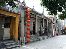
Sam Shing Temple (三聖廟) aka. Shing Miu in Sam Shing Hui.

Plaque commemorating the former Sam Shing Hui village.


Sam Shing Hui ( Chinese: 三聖墟) is an area and a former fishing village in Tuen Mun, Tuen Mun District, Hong Kong.
Wikimedia Commons has media related to
Sam Shing Hui.
22°22′55″N 113°58′38″E / 22.38194°N 113.97722°E
|
| This Hong Kong location article is a stub. You can help Wikipedia by expanding it. |