Saint-Marc-sur-Richelieu | |
|---|---|
 Road 223 in Saint-Marc-sur-Richelieu | |
 Location within La Vallée-du-Richelieu RCM. | |
 Saint-Marc-sur-Richelieu Location in southern Quebec. | |
| Coordinates (<): 45°41′N 73°12′W / 45.683°N 73.200°W [1] | |
| Country | |
| Province | |
| Region | Montérégie |
| RCM | La Vallée-du-Richelieu |
| Constituted | July 1, 1855 |
| Government | |
| • Mayor | Alain Lavallée |
| • Federal riding | Pierre-Boucher—Les Patriotes—Verchères |
| • Prov. riding | Borduas |
| Area | |
| • Total | 62.40 km2 (24.09 sq mi) |
| • Land | 60.92 km2 (23.52 sq mi) |
| Population | |
| • Total | 2,245 |
| • Density | 36.9/km2 (96/sq mi) |
| • Pop 2016-2021 | |
| • Dwellings | 908 |
| Time zone | UTC−5 ( EST) |
| • Summer ( DST) | UTC−4 ( EDT) |
| Postal code(s) | |
| Area code(s) | 450 and 579 |
| Highways | |
| Website |
www.ville.saint-marc- sur-richelieu.qc.ca |
Saint-Marc-sur-Richelieu is a municipality in southwestern Quebec, Canada, on the Richelieu River in the Regional County Municipality of La Vallée-du-Richelieu. The population as of the Canada 2021 Census was 2,245.
In its origin, the municipality was simply named: Saint-Marc. In 1921, the municipality lost an important part of it's territory for the creation of the new municipality of Saint-Amable. In 1980, the municipality of Saint-Marc changed it's name to the current name of Saint-Marc-sur-Richelieu.
On October 10, 2012, the municipality was reportedly the epicenter of an earthquake measuring 4.5 on the Richter scale. [5]
|
Population trend: [6]
|
Mother tongue language (2021) [7]
|
-
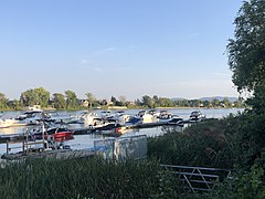 Richelieu River
 -
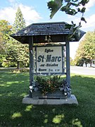 Parish Church Sign
 -
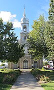 Parish Church
 -
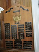 Parish Priests Plaque
 -
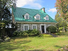 Maison Janotte, 1760
 -
 Maison Senecal-Moreau, 1762
 -
 Maison Isidore Blanchard, 1763
 -
 Hôtel Les Trois Tillleuls


- ^ "Banque de noms de lieux du Québec: Reference number 287692". toponymie.gouv.qc.ca (in French). Commission de toponymie du Québec.
- ^ a b Ministère des Affaires municipales, des Régions et de l'Occupation du territoire: Saint-Marc-sur-Richelieu
- ^ Parliament of Canada Federal Riding History: VERCHÈRES--LES PATRIOTES (Quebec)
- ^ a b 2021 Statistics Canada Census Profile: Saint-Marc-sur-Richelieu, Quebec
- ^ https://www.journaldemontreal.com/2012/10/10/un-tremblement-de-terre-secoue-la-region-de-montreal
- ^ Statistics Canada: 1996, 2001, 2006, 2011 census
- ^ 2021 Statistics Canada Community Profile: Saint-Marc-sur-Richelieu, Quebec
Adjacent Municipal Subdivisions | |
|---|---|
| Cities | |
|---|---|
| Municipalities | |
| |
| International | |
|---|---|
| National | |
Saint-Marc-sur-Richelieu | |
|---|---|
|
Road 223 in Saint-Marc-sur-Richelieu | |
|
Location within La Vallée-du-Richelieu RCM. | |
Saint-Marc-sur-Richelieu Location in southern Quebec. | |
| Coordinates (<): 45°41′N 73°12′W / 45.683°N 73.200°W [1] | |
| Country | |
| Province | |
| Region | Montérégie |
| RCM | La Vallée-du-Richelieu |
| Constituted | July 1, 1855 |
| Government | |
| • Mayor | Alain Lavallée |
| • Federal riding | Pierre-Boucher—Les Patriotes—Verchères |
| • Prov. riding | Borduas |
| Area | |
| • Total | 62.40 km2 (24.09 sq mi) |
| • Land | 60.92 km2 (23.52 sq mi) |
| Population | |
| • Total | 2,245 |
| • Density | 36.9/km2 (96/sq mi) |
| • Pop 2016-2021 | |
| • Dwellings | 908 |
| Time zone | UTC−5 ( EST) |
| • Summer ( DST) | UTC−4 ( EDT) |
| Postal code(s) | |
| Area code(s) | 450 and 579 |
| Highways | |
| Website |
www.ville.saint-marc- sur-richelieu.qc.ca |
Saint-Marc-sur-Richelieu is a municipality in southwestern Quebec, Canada, on the Richelieu River in the Regional County Municipality of La Vallée-du-Richelieu. The population as of the Canada 2021 Census was 2,245.
In its origin, the municipality was simply named: Saint-Marc. In 1921, the municipality lost an important part of it's territory for the creation of the new municipality of Saint-Amable. In 1980, the municipality of Saint-Marc changed it's name to the current name of Saint-Marc-sur-Richelieu.
On October 10, 2012, the municipality was reportedly the epicenter of an earthquake measuring 4.5 on the Richter scale. [5]
|
Population trend: [6]
|
Mother tongue language (2021) [7]
|
-
Richelieu River
-
Parish Church Sign
-
Parish Church
-
Parish Priests Plaque
-
Maison Janotte, 1760
-
Maison Senecal-Moreau, 1762
-
Maison Isidore Blanchard, 1763
-
Hôtel Les Trois Tillleuls
- ^ "Banque de noms de lieux du Québec: Reference number 287692". toponymie.gouv.qc.ca (in French). Commission de toponymie du Québec.
- ^ a b Ministère des Affaires municipales, des Régions et de l'Occupation du territoire: Saint-Marc-sur-Richelieu
- ^ Parliament of Canada Federal Riding History: VERCHÈRES--LES PATRIOTES (Quebec)
- ^ a b 2021 Statistics Canada Census Profile: Saint-Marc-sur-Richelieu, Quebec
- ^ https://www.journaldemontreal.com/2012/10/10/un-tremblement-de-terre-secoue-la-region-de-montreal
- ^ Statistics Canada: 1996, 2001, 2006, 2011 census
- ^ 2021 Statistics Canada Community Profile: Saint-Marc-sur-Richelieu, Quebec
Adjacent Municipal Subdivisions | |
|---|---|
| Cities | |
|---|---|
| Municipalities | |
| |
| International | |
|---|---|
| National | |