Saint-Chaffrey
Sant Chafrei (
Occitan) | |
|---|---|
 Parish church of Saint-Chaffrey | |
 Coat of arms | |
 Saint-Chaffrey  Saint-Chaffrey | |
| Coordinates: 44°55′37″N 6°36′27″E / 44.9269°N 6.6075°E | |
| Country | France |
| Region | Provence-Alpes-Côte d'Azur |
| Department | Hautes-Alpes |
| Arrondissement | Briançon |
| Canton | Briançon-1 |
| Intercommunality | Briançonnais |
| Government | |
| • Mayor (2020–2026) | Corinne Chanfray [1] |
| Area 1 | 25.88 km2 (9.99 sq mi) |
| Population (2021)
[2] | 1,515 |
| • Density | 59/km2 (150/sq mi) |
| Demonym | Chaffrelins |
| Time zone | UTC+01:00 ( CET) |
| • Summer ( DST) | UTC+02:00 ( CEST) |
| INSEE/Postal code |
05133 /05330 |
| Elevation | 1,274–2,632 m (4,180–8,635 ft) (avg. 1,365 m or 4,478 ft) |
| Website | www.saint-chaffrey.fr |
| 1 French Land Register data, which excludes lakes, ponds, glaciers > 1 km2 (0.386 sq mi or 247 acres) and river estuaries. | |
Saint-Chaffrey (French pronunciation: [sɛ̃ ʃafʁɛ]; Occitan: Sant Chafrei) is an alpine commune in the Hautes-Alpes department in the Provence-Alpes-Côte d'Azur region in Southeastern France. Saint-Chaffrey is located in the Valley of the Guisane, on the road to Grenoble, between La Salle-les-Alpes to the northwest and Briançon to the southeast.
The commune of Saint-Chaffrey encompasses the villages of Saint-Chaffrey, Chantemerle, Villard-Laté and La Gérarde. It is situated at the heart of the Serre Chevalier ski resort, which has slopes that serve Chantemerle. [3]
| Year | Pop. | ±% p.a. |
|---|---|---|
| 1968 | 831 | — |
| 1975 | 947 | +1.88% |
| 1982 | 1,287 | +4.48% |
| 1990 | 1,424 | +1.27% |
| 1999 | 1,569 | +1.08% |
| 2009 | 1,635 | +0.41% |
| 2014 | 1,645 | +0.12% |
| 2020 | 1,523 | −1.28% |
| Source: INSEE [4] | ||
Several stages of the Tour de France have started or finished in the commune of Saint-Chaffrey: [5]
- Finishes
| Year | Stage | Departure town | Winner |
|---|---|---|---|
| 1974 | 11 | Aix-les-Bains |
Vicente López Carril |
| 1975 | 16 | Barcelonnette |
Bernard Thévenet |
| 1986 | 17 [6] | Gap |
Eduardo Chozas |
| 1993 | 10 | Villard-de-Lans |
Tony Rominger |
- Starts
| Year | Stage | Finish town | Winner |
|---|---|---|---|
| 1980 | 17 | Morzine |
Mario Martinez |
| 1993 | 11 | Isola 2000 |
Tony Rominger |
-
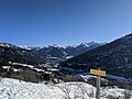 Overlooking the valley at Saint-Chaffrey and Briançon from high up on the Col du Granon in winter
 -
 Saint-Chaffrey Town Hall


- ^ "Répertoire national des élus: les maires" (in French). data.gouv.fr, Plateforme ouverte des données publiques françaises. 13 September 2022.
- ^ "Populations légales 2021" (in French). The National Institute of Statistics and Economic Studies. 28 December 2023.
- ^ "St Chaffrey - Chantemerle", Serre Chevalier Vallée Briançon.
- ^ Population en historique depuis 1968, INSEE
- ^ Tour de France at Saint-Chaffrey on ledicodutour.
- ^ Arrival at col du Granon
Saint-Chaffrey
Sant Chafrei (
Occitan) | |
|---|---|
|
Parish church of Saint-Chaffrey | |
|
Coat of arms | |
Saint-Chaffrey Saint-Chaffrey | |
| Coordinates: 44°55′37″N 6°36′27″E / 44.9269°N 6.6075°E | |
| Country | France |
| Region | Provence-Alpes-Côte d'Azur |
| Department | Hautes-Alpes |
| Arrondissement | Briançon |
| Canton | Briançon-1 |
| Intercommunality | Briançonnais |
| Government | |
| • Mayor (2020–2026) | Corinne Chanfray [1] |
| Area 1 | 25.88 km2 (9.99 sq mi) |
| Population (2021)
[2] | 1,515 |
| • Density | 59/km2 (150/sq mi) |
| Demonym | Chaffrelins |
| Time zone | UTC+01:00 ( CET) |
| • Summer ( DST) | UTC+02:00 ( CEST) |
| INSEE/Postal code |
05133 /05330 |
| Elevation | 1,274–2,632 m (4,180–8,635 ft) (avg. 1,365 m or 4,478 ft) |
| Website | www.saint-chaffrey.fr |
| 1 French Land Register data, which excludes lakes, ponds, glaciers > 1 km2 (0.386 sq mi or 247 acres) and river estuaries. | |
Saint-Chaffrey (French pronunciation: [sɛ̃ ʃafʁɛ]; Occitan: Sant Chafrei) is an alpine commune in the Hautes-Alpes department in the Provence-Alpes-Côte d'Azur region in Southeastern France. Saint-Chaffrey is located in the Valley of the Guisane, on the road to Grenoble, between La Salle-les-Alpes to the northwest and Briançon to the southeast.
The commune of Saint-Chaffrey encompasses the villages of Saint-Chaffrey, Chantemerle, Villard-Laté and La Gérarde. It is situated at the heart of the Serre Chevalier ski resort, which has slopes that serve Chantemerle. [3]
| Year | Pop. | ±% p.a. |
|---|---|---|
| 1968 | 831 | — |
| 1975 | 947 | +1.88% |
| 1982 | 1,287 | +4.48% |
| 1990 | 1,424 | +1.27% |
| 1999 | 1,569 | +1.08% |
| 2009 | 1,635 | +0.41% |
| 2014 | 1,645 | +0.12% |
| 2020 | 1,523 | −1.28% |
| Source: INSEE [4] | ||
Several stages of the Tour de France have started or finished in the commune of Saint-Chaffrey: [5]
- Finishes
| Year | Stage | Departure town | Winner |
|---|---|---|---|
| 1974 | 11 | Aix-les-Bains |
Vicente López Carril |
| 1975 | 16 | Barcelonnette |
Bernard Thévenet |
| 1986 | 17 [6] | Gap |
Eduardo Chozas |
| 1993 | 10 | Villard-de-Lans |
Tony Rominger |
- Starts
| Year | Stage | Finish town | Winner |
|---|---|---|---|
| 1980 | 17 | Morzine |
Mario Martinez |
| 1993 | 11 | Isola 2000 |
Tony Rominger |
-
Overlooking the valley at Saint-Chaffrey and Briançon from high up on the Col du Granon in winter
-
Saint-Chaffrey Town Hall
- ^ "Répertoire national des élus: les maires" (in French). data.gouv.fr, Plateforme ouverte des données publiques françaises. 13 September 2022.
- ^ "Populations légales 2021" (in French). The National Institute of Statistics and Economic Studies. 28 December 2023.
- ^ "St Chaffrey - Chantemerle", Serre Chevalier Vallée Briançon.
- ^ Population en historique depuis 1968, INSEE
- ^ Tour de France at Saint-Chaffrey on ledicodutour.
- ^ Arrival at col du Granon