| Sahuasiray | |
|---|---|
| Ccolque Cruz | |
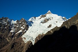
 Snow covered Sahuasiray. | |
| Highest point | |
| Elevation | 5,818 m (19,088 ft) |
| Prominence | 1,920 m (6,300 ft) [1] |
| Listing | Ultra |
| Coordinates | 13°12′50″S 71°59′18″W / 13.21389°S 71.98833°W |
| Geography | |
| Location | Cusco, Peru |
| Parent range | Urubamba, Andes |
| Climbing | |
| First ascent | Sahuasiray N: 1-1963 via E. ridge. Sahuasiray S: 1-1968 [2] |
Sahuasiray [1] [2] [3] [4] [5] (possibly from Quechua sawa matrimony, siray to sew, [6]), Sawasiray, [7] Colque Cruz [1] or Ccolque Cruz [8] (possibly from Aymara and Quechua qullqi silver, money, Spanish cruz cross, "silver cross")[ citation needed], is one of the highest mountains in the Urubamba mountain range in the Andes of Peru, about 5,818 metres (19,088 ft) high. [3] [8] It lies in the Cusco Region, Calca Province, northwest of Calca. It is situated northeast of Chicón and Canchacanchajasa, southeast of Sirihuani and northwest of Condorhuachana.
See also
References
- ^ a b c "Peru: 22 Mountain Summits with Prominence of 1,500 meters or greater" Listed here as "Sahuasiray (Nevado Colque Cruz)" Peaklist.org. Retrieved 2013-03-02.
- ^ a b Jill Neate, Mountaineering in the Andes, 1994
- ^ a b Biggar, John (2005). The Andes: A Guide for Climbers. Andes. p. 113. ISBN 9780953608720.
- ^ Jenkins, Dilwyn (2005). The Rough Guide to Peru. Rough Guides. p. 158.
- ^ "Nevado Sahuasiray - Peakbagger.com". www.peakbagger.com. Retrieved 2016-07-14.
- ^ Teofilo Laime Ajacopa, Diccionario Bilingüe Iskay simipi yuyayk'ancha, La Paz, 2007 (Quechua-Spanish dictionary): sawa. s. Matrimonio. Casamiento, nupcias. siray. tr. Coser. Unir mediante puntadas.
- ^ Gade, Daniel (2015). Spell of the Urubamba: Anthropogeographical Essays on an Andean Valley in Space and Time. Springer. p. 133. ISBN 9783319208497.
- ^ a b Peru 1:100 000, Calca (27-s). IGN (Instituto Geográfico Nacional - Perú).
External links
| Sahuasiray | |
|---|---|
| Ccolque Cruz | |
 Snow covered Sahuasiray. | |
| Highest point | |
| Elevation | 5,818 m (19,088 ft) |
| Prominence | 1,920 m (6,300 ft) [1] |
| Listing | Ultra |
| Coordinates | 13°12′50″S 71°59′18″W / 13.21389°S 71.98833°W |
| Geography | |
| Location | Cusco, Peru |
| Parent range | Urubamba, Andes |
| Climbing | |
| First ascent | Sahuasiray N: 1-1963 via E. ridge. Sahuasiray S: 1-1968 [2] |
Sahuasiray [1] [2] [3] [4] [5] (possibly from Quechua sawa matrimony, siray to sew, [6]), Sawasiray, [7] Colque Cruz [1] or Ccolque Cruz [8] (possibly from Aymara and Quechua qullqi silver, money, Spanish cruz cross, "silver cross")[ citation needed], is one of the highest mountains in the Urubamba mountain range in the Andes of Peru, about 5,818 metres (19,088 ft) high. [3] [8] It lies in the Cusco Region, Calca Province, northwest of Calca. It is situated northeast of Chicón and Canchacanchajasa, southeast of Sirihuani and northwest of Condorhuachana.
See also
References
- ^ a b c "Peru: 22 Mountain Summits with Prominence of 1,500 meters or greater" Listed here as "Sahuasiray (Nevado Colque Cruz)" Peaklist.org. Retrieved 2013-03-02.
- ^ a b Jill Neate, Mountaineering in the Andes, 1994
- ^ a b Biggar, John (2005). The Andes: A Guide for Climbers. Andes. p. 113. ISBN 9780953608720.
- ^ Jenkins, Dilwyn (2005). The Rough Guide to Peru. Rough Guides. p. 158.
- ^ "Nevado Sahuasiray - Peakbagger.com". www.peakbagger.com. Retrieved 2016-07-14.
- ^ Teofilo Laime Ajacopa, Diccionario Bilingüe Iskay simipi yuyayk'ancha, La Paz, 2007 (Quechua-Spanish dictionary): sawa. s. Matrimonio. Casamiento, nupcias. siray. tr. Coser. Unir mediante puntadas.
- ^ Gade, Daniel (2015). Spell of the Urubamba: Anthropogeographical Essays on an Andean Valley in Space and Time. Springer. p. 133. ISBN 9783319208497.
- ^ a b Peru 1:100 000, Calca (27-s). IGN (Instituto Geográfico Nacional - Perú).
External links
