Saasveld | |
|---|---|
village | |
 Saint Plechelmus Church in Saasveld | |
| Nickname: Koffiedreenkers | |
 The town centre (dark green) and the statistical district (light green) of Saasveld in the municipality of Dinkelland. | |
 Saasveld Location in the Netherlands  Saasveld Saasveld (Netherlands) | |
| Coordinates: 52°19′52″N 6°48′23″E / 52.33111°N 6.80639°E | |
| Country | Netherlands |
| Province | Overijssel |
| Municipality | Dinkelland |
| Area | |
| • Total | 21.98 km2 (8.49 sq mi) |
| Elevation | 18 m (59 ft) |
| Population (2021)
[1] | |
| • Total | 1,700 |
| • Density | 77/km2 (200/sq mi) |
| Demonym(s) | Saasveldenaars, Saasvelders, Soaseler |
| Time zone | UTC+1 ( CET) |
| • Summer ( DST) | UTC+2 ( CEST) |
| Postal code | 7597
[1] |
| Dialing code | 074 |
Saasveld is a village in the Dutch province of Overijssel. It is a part of the municipality of Dinkelland, and lies about 7 km north of Hengelo.
Overview
It was first mentioned in 1145 as Saterslo. The etymology is unclear. [3] The castle Saterslo was first mentioned in 1361. It was surrounded by swaps and often raided the countryside. [4] After the reformation, a clandestine church was constructed inside the castle. [5] The castle was demolished in 1818, [4] and a church was built in Saasveld. [6] The current Saint Plechelmus Church dates from 1926, [5] and is 46 metres (151 ft) tall. [6] In 1870, the gristmill Soaseler Möl was constructed. [7]
Gallery
-
 Village shop (1983)
 -
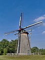 Windmill Soaseler Möl
 -
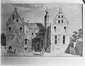 Drawing of Saterslo (1722-1748)


References
- ^ a b c "Kerncijfers wijken en buurten 2021". Central Bureau of Statistics. Retrieved 15 March 2022.
- ^ "Postcodetool for 7597KA". Actueel Hoogtebestand Nederland (in Dutch). Het Waterschapshuis. Retrieved 15 March 2022.
- ^ "Saasveld - (geografische naam)". Etymologiebank (in Dutch). Retrieved 15 March 2022.
- ^ a b "Saterslo". Kastelen in Overijssel (in Dutch). Retrieved 15 March 2022.
- ^ a b Ronald Stenvert & Jan ten Hove (1998). "Saasveld" (in Dutch). Zwolle: Waanders. ISBN 90 400 9200 1. Retrieved 15 March 2022.
- ^ a b "Saasveld". Plaatsengids (in Dutch). Retrieved 15 March 2022.
- ^ "Soaseler Möl". Molendatabase (in Dutch). Retrieved 15 March 2022.
|
| This Overijssel location article is a stub. You can help Wikipedia by expanding it. |
Saasveld | |
|---|---|
village | |
|
Saint Plechelmus Church in Saasveld | |
| Nickname: Koffiedreenkers | |
|
The town centre (dark green) and the statistical district (light green) of Saasveld in the municipality of Dinkelland. | |
Saasveld Location in the Netherlands Saasveld Saasveld (Netherlands) | |
| Coordinates: 52°19′52″N 6°48′23″E / 52.33111°N 6.80639°E | |
| Country | Netherlands |
| Province | Overijssel |
| Municipality | Dinkelland |
| Area | |
| • Total | 21.98 km2 (8.49 sq mi) |
| Elevation | 18 m (59 ft) |
| Population (2021)
[1] | |
| • Total | 1,700 |
| • Density | 77/km2 (200/sq mi) |
| Demonym(s) | Saasveldenaars, Saasvelders, Soaseler |
| Time zone | UTC+1 ( CET) |
| • Summer ( DST) | UTC+2 ( CEST) |
| Postal code | 7597
[1] |
| Dialing code | 074 |
Saasveld is a village in the Dutch province of Overijssel. It is a part of the municipality of Dinkelland, and lies about 7 km north of Hengelo.
Overview
It was first mentioned in 1145 as Saterslo. The etymology is unclear. [3] The castle Saterslo was first mentioned in 1361. It was surrounded by swaps and often raided the countryside. [4] After the reformation, a clandestine church was constructed inside the castle. [5] The castle was demolished in 1818, [4] and a church was built in Saasveld. [6] The current Saint Plechelmus Church dates from 1926, [5] and is 46 metres (151 ft) tall. [6] In 1870, the gristmill Soaseler Möl was constructed. [7]
Gallery
-
Village shop (1983)
-
Windmill Soaseler Möl
-
Drawing of Saterslo (1722-1748)
References
- ^ a b c "Kerncijfers wijken en buurten 2021". Central Bureau of Statistics. Retrieved 15 March 2022.
- ^ "Postcodetool for 7597KA". Actueel Hoogtebestand Nederland (in Dutch). Het Waterschapshuis. Retrieved 15 March 2022.
- ^ "Saasveld - (geografische naam)". Etymologiebank (in Dutch). Retrieved 15 March 2022.
- ^ a b "Saterslo". Kastelen in Overijssel (in Dutch). Retrieved 15 March 2022.
- ^ a b Ronald Stenvert & Jan ten Hove (1998). "Saasveld" (in Dutch). Zwolle: Waanders. ISBN 90 400 9200 1. Retrieved 15 March 2022.
- ^ a b "Saasveld". Plaatsengids (in Dutch). Retrieved 15 March 2022.
- ^ "Soaseler Möl". Molendatabase (in Dutch). Retrieved 15 March 2022.
|
| This Overijssel location article is a stub. You can help Wikipedia by expanding it. |