Saalfeld | |
|---|---|
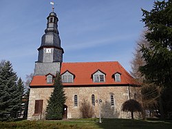
 St Nicholas's Church | |
| Coordinates: 51°15′49″N 10°31′42″E / 51.263689°N 10.528314°E | |
| Country | Germany |
| State | Thuringia |
| District | Unstrut-Hainich-Kreis |
| Town | Mühlhausen |
| First mentioned | 1273 |
| Government | |
| • Ortsteilbürgermeister | Silvio Fischer [1] |
| Elevation | 352 m (1,155 ft) |
| Population (March 2021)
[2] | |
| • Total | 162 |
| Time zone | UTC+01:00 ( CET) |
| • Summer ( DST) | UTC+02:00 ( CEST) |
| Postal codes | 99974 |
| Dialling codes | 036029 |
| Vehicle registration | UH, LSZ, MHL |
| Website | muehlhausen.de |
Saalfeld (pronounced [ˈzaːlfɛld]) is a village and a quarter of the town of Mühlhausen in Thuringia, central Germany.
Geography
Saalfeld lies on the edge of the Thuringian Basin, several kilometres (miles) north of the core town of Mühlhausen. The village is connected to the town and the surrounding area via the Landesstraße (state's road) 1016.
History

The village was first mentioned in a document on 29 October 1273. [3] For centuries, it belonged to the sphere of influence of the Reichsstadt (imperial city) of Mühlhausen. In 1565, the (male) population of Saalfeld was 46. [4] In 1802, Saalfeld, together with Mühlhausen, fell to the Kingdom of Prussia, from 1807 to 1813 to the Kingdom of Westphalia (canton Dachrieden) created by Napoleon, and after the Congress of Vienna in 1816, it was assigned to the Landkreis Mühlhausen i. Th. in the Prussian Province of Saxony. On 8 March 1994, Saalfeld was incorporated into the town of Mühlhausen. [1]
Sights
References
- ^ a b c "Der Ortsteil Saalfeld" [The village of Saalfeld] (in German). Stadt Mühlhausen. Retrieved 17 May 2022.
- ^ "Einwohnerstatistik" [Population figures] (in German). Stadt Mühlhausen. Retrieved 8 June 2022.
- ^ Kahl, Wolfgang (2010). Ersterwähnung Thüringer Städte und Dörfer. Ein Handbuch [First mentions of Thuringia's towns and villages. A handbook] (in German) (5th ed.). Bad Langensalza: Rockstuhl. p. 243. ISBN 978-3-86777-202-0.
- ^ Jordan, Reinhard, ed. (1900). Chronik der Stadt Mühlhausen in Thüringen [Chronicle of the town of Mühlhausen in Thuringia] (in German). Vol. 1: (–1525). Mühlhausen: Danner. p. 41.
External links
![]() Media related to
Saalfeld (Mühlhausen) at Wikimedia Commons
Media related to
Saalfeld (Mühlhausen) at Wikimedia Commons
Saalfeld | |
|---|---|
 St Nicholas's Church | |
| Coordinates: 51°15′49″N 10°31′42″E / 51.263689°N 10.528314°E | |
| Country | Germany |
| State | Thuringia |
| District | Unstrut-Hainich-Kreis |
| Town | Mühlhausen |
| First mentioned | 1273 |
| Government | |
| • Ortsteilbürgermeister | Silvio Fischer [1] |
| Elevation | 352 m (1,155 ft) |
| Population (March 2021)
[2] | |
| • Total | 162 |
| Time zone | UTC+01:00 ( CET) |
| • Summer ( DST) | UTC+02:00 ( CEST) |
| Postal codes | 99974 |
| Dialling codes | 036029 |
| Vehicle registration | UH, LSZ, MHL |
| Website | muehlhausen.de |
Saalfeld (pronounced [ˈzaːlfɛld]) is a village and a quarter of the town of Mühlhausen in Thuringia, central Germany.
Geography
Saalfeld lies on the edge of the Thuringian Basin, several kilometres (miles) north of the core town of Mühlhausen. The village is connected to the town and the surrounding area via the Landesstraße (state's road) 1016.
History

The village was first mentioned in a document on 29 October 1273. [3] For centuries, it belonged to the sphere of influence of the Reichsstadt (imperial city) of Mühlhausen. In 1565, the (male) population of Saalfeld was 46. [4] In 1802, Saalfeld, together with Mühlhausen, fell to the Kingdom of Prussia, from 1807 to 1813 to the Kingdom of Westphalia (canton Dachrieden) created by Napoleon, and after the Congress of Vienna in 1816, it was assigned to the Landkreis Mühlhausen i. Th. in the Prussian Province of Saxony. On 8 March 1994, Saalfeld was incorporated into the town of Mühlhausen. [1]
Sights
References
- ^ a b c "Der Ortsteil Saalfeld" [The village of Saalfeld] (in German). Stadt Mühlhausen. Retrieved 17 May 2022.
- ^ "Einwohnerstatistik" [Population figures] (in German). Stadt Mühlhausen. Retrieved 8 June 2022.
- ^ Kahl, Wolfgang (2010). Ersterwähnung Thüringer Städte und Dörfer. Ein Handbuch [First mentions of Thuringia's towns and villages. A handbook] (in German) (5th ed.). Bad Langensalza: Rockstuhl. p. 243. ISBN 978-3-86777-202-0.
- ^ Jordan, Reinhard, ed. (1900). Chronik der Stadt Mühlhausen in Thüringen [Chronicle of the town of Mühlhausen in Thuringia] (in German). Vol. 1: (–1525). Mühlhausen: Danner. p. 41.
External links
![]() Media related to
Saalfeld (Mühlhausen) at Wikimedia Commons
Media related to
Saalfeld (Mühlhausen) at Wikimedia Commons

