Sárospatak District
Sárospataki járás | |
|---|---|
 Coat of arms | |
 Sárospatak District within Hungary and Borsod-Abaúj-Zemplén County. | |
| Country | |
| County | Borsod-Abaúj-Zemplén |
| District seat | Sárospatak |
| Area | |
| • Total | 477.67 km2 (184.43 sq mi) |
| • Rank | 5th in Borsod-Abaúj-Zemplén |
| Population (2011 census) | |
| • Total | 24,946 |
| • Rank | 8th in Borsod-Abaúj-Zemplén |
| • Density | 52/km2 (130/sq mi) |
Sárospatak ( Hungarian: Sárospataki járás) is a district in north-eastern part of Borsod-Abaúj-Zemplén County. Sárospatak is also the name of the town where the district seat is found. The district is located in the Northern Hungary Statistical Region.
Sárospatak District borders with Sátoraljaújhely District to the north, Cigánd District to the east, Ibrány District and Nyíregyháza District ( Szabolcs-Szatmár-Bereg County) to the south, Tokaj District and Gönc District to the west. The number of the inhabited places in Sárospatak District is 16.
The district has 1 town and 15 villages. (ordered by population, as of 1 January 2012) [1]
- Bodrogolaszi (882)
- Erdőhorváti (545)
- Györgytarló (563)
- Háromhuta (125)
- Hercegkút (624)
- Kenézlő (1,229)
- Komlóska (237)
- Makkoshotyka (869)
- Olaszliszka (1,661)
- Sárazsadány (249)
- Sárospatak (12,590) – district seat
- Tolcsva (1,681)
- Vajdácska (1,302)
- Vámosújfalu (857)
- Viss (631)
- Zalkod (201)
The bolded municipality is the city.
Religion in Sárospatak District (2011 census)
In 2011, it had a population of 24,946 and the population density was 52/km².
| Year | County population [2] | Change |
|---|---|---|
| 2011 | 24,946 | n/a |
Besides the Hungarian majority, the main minorities are the Roma (approx. 1,500), German (650) and Rusyn (350).
Total population (2011 census): 24,946
Ethnic groups (2011 census):
[3] Identified themselves: 23,789 persons:
- Hungarians: 21,009 (88.31%)
- Gypsies: 1,502 (6.31%)
- Germans: 629 (2.64%)
- Rusyns: 359 (1.51%)
- Others and indefinable: 290 (1.22%)
Approx. 1,000 people in Sárospatak District did not declare their ethnic group at the 2011 census.
Religious adherence in the county according to 2011 census: [4]
- Catholic – 11,714 ( Roman Catholic – 8,376; Greek Catholic – 3,331);
- Reformed – 5,600;
- Evangelical – 36;
- other religions – 332;
- Non-religious – 1,009;
- Atheism – 100;
- Undeclared – 6,155.
-

-
 Aerial view of Háromhuta (Óhuta)
 -
 Meczner Mansion in Makkoshotyka
 -
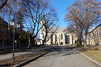 Castle Church in Sárospatak


_-_Makkoshotyka,_2014.06.19_(1).JPG)

- ^ A KSH 2012. évi helységnévkönyve
- ^ népesség.com, "Sárospataki járás népessége"
- ^ 4.1.6.1 A népesség nemzetiség szerint, 2011, (in Hungarian) [1]
- ^ 4.1.7.1 A népesség vallás, felekezet szerint, 2011, (in Hungarian) [2]
| Town (1) |
| |
|---|---|---|
| Villages (15) | ||
48°18′00″N 21°31′00″E / 48.3000°N 21.5167°E
|
| This Borsod-Abaúj-Zemplén location article is a stub. You can help Wikipedia by expanding it. |
Sárospatak District
Sárospataki járás | |
|---|---|
|
Coat of arms | |
|
Sárospatak District within Hungary and Borsod-Abaúj-Zemplén County. | |
| Country | |
| County | Borsod-Abaúj-Zemplén |
| District seat | Sárospatak |
| Area | |
| • Total | 477.67 km2 (184.43 sq mi) |
| • Rank | 5th in Borsod-Abaúj-Zemplén |
| Population (2011 census) | |
| • Total | 24,946 |
| • Rank | 8th in Borsod-Abaúj-Zemplén |
| • Density | 52/km2 (130/sq mi) |
Sárospatak ( Hungarian: Sárospataki járás) is a district in north-eastern part of Borsod-Abaúj-Zemplén County. Sárospatak is also the name of the town where the district seat is found. The district is located in the Northern Hungary Statistical Region.
Sárospatak District borders with Sátoraljaújhely District to the north, Cigánd District to the east, Ibrány District and Nyíregyháza District ( Szabolcs-Szatmár-Bereg County) to the south, Tokaj District and Gönc District to the west. The number of the inhabited places in Sárospatak District is 16.
The district has 1 town and 15 villages. (ordered by population, as of 1 January 2012) [1]
- Bodrogolaszi (882)
- Erdőhorváti (545)
- Györgytarló (563)
- Háromhuta (125)
- Hercegkút (624)
- Kenézlő (1,229)
- Komlóska (237)
- Makkoshotyka (869)
- Olaszliszka (1,661)
- Sárazsadány (249)
- Sárospatak (12,590) – district seat
- Tolcsva (1,681)
- Vajdácska (1,302)
- Vámosújfalu (857)
- Viss (631)
- Zalkod (201)
The bolded municipality is the city.
Religion in Sárospatak District (2011 census)
In 2011, it had a population of 24,946 and the population density was 52/km².
| Year | County population [2] | Change |
|---|---|---|
| 2011 | 24,946 | n/a |
Besides the Hungarian majority, the main minorities are the Roma (approx. 1,500), German (650) and Rusyn (350).
Total population (2011 census): 24,946
Ethnic groups (2011 census):
[3] Identified themselves: 23,789 persons:
- Hungarians: 21,009 (88.31%)
- Gypsies: 1,502 (6.31%)
- Germans: 629 (2.64%)
- Rusyns: 359 (1.51%)
- Others and indefinable: 290 (1.22%)
Approx. 1,000 people in Sárospatak District did not declare their ethnic group at the 2011 census.
Religious adherence in the county according to 2011 census: [4]
- Catholic – 11,714 ( Roman Catholic – 8,376; Greek Catholic – 3,331);
- Reformed – 5,600;
- Evangelical – 36;
- other religions – 332;
- Non-religious – 1,009;
- Atheism – 100;
- Undeclared – 6,155.
-
-
Aerial view of Háromhuta (Óhuta)
-
Meczner Mansion in Makkoshotyka
-
Castle Church in Sárospatak
- ^ A KSH 2012. évi helységnévkönyve
- ^ népesség.com, "Sárospataki járás népessége"
- ^ 4.1.6.1 A népesség nemzetiség szerint, 2011, (in Hungarian) [1]
- ^ 4.1.7.1 A népesség vallás, felekezet szerint, 2011, (in Hungarian) [2]
| Town (1) |
| |
|---|---|---|
| Villages (15) | ||
48°18′00″N 21°31′00″E / 48.3000°N 21.5167°E
|
| This Borsod-Abaúj-Zemplén location article is a stub. You can help Wikipedia by expanding it. |