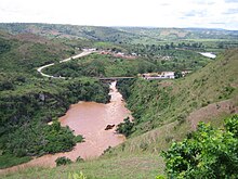

Rusumo was a district (akarere) in the former Rwandan province of Kibungo. The district was abolished, along with the Kibungo Province, during local government reorganisation in 2006. [1] The area covered by the Rusumo district is now contained in the larger Kirehe District, within the Eastern Province. Population: 149,643 (2002 figures); area: 601 square kilometers. It is separated from Tanzania by the Kagera River, which is distinguished by the Rusumo Falls.
Town
There is also a town of the same name.
Statistics
- Population = 17,393
See also
- Railway stations in Rwanda - proposed
References
- ^ BBC News (I) (2006-01-03). "Rwanda redrawn to reflect compass". Retrieved 2012-02-16.
- "Districts of Rwanda". Statoids.
02°16′23″S 30°42′33″E / 2.27306°S 30.70917°E