Rusnė | |
|---|---|
Town | |
 | |
 Flag  Coat of arms | |
 Rusnė Location of Rusnė | |
| Coordinates: 55°17′50″N 21°22′40″E / 55.29722°N 21.37778°E | |
| Country | |
| County |
|
| Municipality | Šilutė district municipality |
| Elderate | Rusnė elderate |
| Population (2021) | |
| • Total | 1,131 |
| Time zone | UTC+2 ( EET) |
| • Summer ( DST) | UTC+3 ( EEST) |
|
| |
Rusnė ( German: Ruß) is a border town in Šilutė district, Lithuania, located on the Rusnė Island in the Nemunas Delta, 9 km south-west from Šilutė.
Rusnė was first mentioned in historical sources in the 14th century. In 1419 the first church was built in Rusnė, and in 1553 a Lithuanian parish school was established. [1] In 1863 the Rusnė synagogue opened.
In 1946 Rusnė received municipal rights, and in 1967 the whole Island of Rusnė was given this status.
Some parts of the town of Rusnė near Lake Dumblė are located below the sea level [2] and are the lowest in Lithuania.
Rusnė is on the Russian border, which is marked by the Skirvytė river. [2]

Rusnė town and Rusnė island is very popular place for angling, as Nemunas delta is rich in various kinds of fish, and tourism infrastructure is built up in recent years. It is also a popular place for birdwatching.
- Heinrich Ancker (1850-1900), member of the Reichstag
- Gerhard Gregor (1906–1981), musician
- Rudolf Jenett (1914–1998), majorgeneral of the Bundeswehr
- Hermann Kallenbach (1871-1945) architect
- Charlotte Keyser (1890-1966), writer
- Otto D. Tolischus (1890–1967), journalist
-
 View of Rusnė from Pakalnė and Neman confluence
 -
 Rusnė housing
 -
 Old Rusnė rectory, now a post office
 -
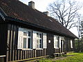 Ethnographic museum near Rusnė
 -
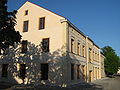
 House in the Rusnė central square
 -
 Anglers on Rusnė island
 -
 Neringa street
 -
 Lutheran church in Rusnė
 -
 The church (1809) in Rusnė


- ^ Nemunas Delta Regional Park website Archived 2011-03-12 at the Wayback Machine Accessed September 16, 2006
- ^ a b Nemunas Water Route:Your Guide To The River Nemuna. State Tourism Department under the Ministry of the Economy. 2007. p. 158.

| International | |
|---|---|
| National | |
Rusnė | |
|---|---|
Town | |
|
| |
|
Flag Coat of arms | |
Rusnė Location of Rusnė | |
| Coordinates: 55°17′50″N 21°22′40″E / 55.29722°N 21.37778°E | |
| Country | |
| County |
|
| Municipality | Šilutė district municipality |
| Elderate | Rusnė elderate |
| Population (2021) | |
| • Total | 1,131 |
| Time zone | UTC+2 ( EET) |
| • Summer ( DST) | UTC+3 ( EEST) |
|
| |
Rusnė ( German: Ruß) is a border town in Šilutė district, Lithuania, located on the Rusnė Island in the Nemunas Delta, 9 km south-west from Šilutė.
Rusnė was first mentioned in historical sources in the 14th century. In 1419 the first church was built in Rusnė, and in 1553 a Lithuanian parish school was established. [1] In 1863 the Rusnė synagogue opened.
In 1946 Rusnė received municipal rights, and in 1967 the whole Island of Rusnė was given this status.
Some parts of the town of Rusnė near Lake Dumblė are located below the sea level [2] and are the lowest in Lithuania.
Rusnė is on the Russian border, which is marked by the Skirvytė river. [2]
Rusnė town and Rusnė island is very popular place for angling, as Nemunas delta is rich in various kinds of fish, and tourism infrastructure is built up in recent years. It is also a popular place for birdwatching.
- Heinrich Ancker (1850-1900), member of the Reichstag
- Gerhard Gregor (1906–1981), musician
- Rudolf Jenett (1914–1998), majorgeneral of the Bundeswehr
- Hermann Kallenbach (1871-1945) architect
- Charlotte Keyser (1890-1966), writer
- Otto D. Tolischus (1890–1967), journalist
-
View of Rusnė from Pakalnė and Neman confluence
-
Rusnė housing
-
Old Rusnė rectory, now a post office
-
Ethnographic museum near Rusnė
-
House in the Rusnė central square
-
Anglers on Rusnė island
-
Neringa street
-
Lutheran church in Rusnė
-
The church (1809) in Rusnė
- ^ Nemunas Delta Regional Park website Archived 2011-03-12 at the Wayback Machine Accessed September 16, 2006
- ^ a b Nemunas Water Route:Your Guide To The River Nemuna. State Tourism Department under the Ministry of the Economy. 2007. p. 158.
| International | |
|---|---|
| National | |