Ruffec | |
|---|---|
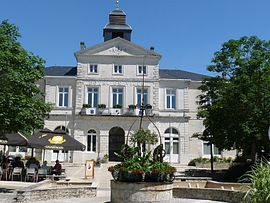
 Town hall | |
| Coordinates: 46°01′46″N 0°12′00″E / 46.0294°N 0.2°E | |
| Country | France |
| Region | Nouvelle-Aquitaine |
| Department | Charente |
| Arrondissement | Confolens |
| Canton | Charente-Nord |
| Government | |
| • Mayor (2020–2026) | Thierry Bastier [1] |
| Area 1 | 13.37 km2 (5.16 sq mi) |
| Population (2021)
[2] | 3,353 |
| • Density | 250/km2 (650/sq mi) |
| Time zone | UTC+01:00 ( CET) |
| • Summer ( DST) | UTC+02:00 ( CEST) |
| INSEE/Postal code |
16292 /16700 |
| Elevation | 83–145 m (272–476 ft) |
| 1 French Land Register data, which excludes lakes, ponds, glaciers > 1 km2 (0.386 sq mi or 247 acres) and river estuaries. | |
Ruffec (French pronunciation: [ʁyfɛk]) is a commune in the Charente department in southwestern France.
It is a stopover town on the road from Paris to Spain ( Route nationale 10), between Poitiers and Angoulême.
During the Second World War, Ruffec was at the centre of Resistance for the evacuation of the Allied airmen towards Spain. [3]
Population
Its inhabitants are known as the Ruffécois or the Ruffécoises in French. [4]
|
| |||||||||||||||||||||||||||||||||||||||||||||||||||||||||||||||||||||||||||||||||||||||||||||||||||||||||||||||
| Source: EHESS [5] and INSEE (1968-2017) [6] | ||||||||||||||||||||||||||||||||||||||||||||||||||||||||||||||||||||||||||||||||||||||||||||||||||||||||||||||||
Twin towns – sister cities
Ruffec is twinned with:
See also
References
- ^ "Répertoire national des élus: les maires". data.gouv.fr, Plateforme ouverte des données publiques françaises (in French). 2 December 2020.
- ^ "Populations légales 2021". The National Institute of Statistics and Economic Studies. 28 December 2023.
- ^ "Ruffec, histoire et patrimoine - Mairie Ruffec". www.mairie-ruffec.fr. Retrieved 17 December 2019.
- ^ "Le nom des habitants du 16 - Charente - Habitants". www.habitants.fr. Retrieved 17 December 2019.
- ^ Des villages de Cassini aux communes d'aujourd'hui: Commune data sheet Ruffec, EHESS (in French).
- ^ Population en historique depuis 1968, INSEE
Ruffec | |
|---|---|
 Town hall | |
| Coordinates: 46°01′46″N 0°12′00″E / 46.0294°N 0.2°E | |
| Country | France |
| Region | Nouvelle-Aquitaine |
| Department | Charente |
| Arrondissement | Confolens |
| Canton | Charente-Nord |
| Government | |
| • Mayor (2020–2026) | Thierry Bastier [1] |
| Area 1 | 13.37 km2 (5.16 sq mi) |
| Population (2021)
[2] | 3,353 |
| • Density | 250/km2 (650/sq mi) |
| Time zone | UTC+01:00 ( CET) |
| • Summer ( DST) | UTC+02:00 ( CEST) |
| INSEE/Postal code |
16292 /16700 |
| Elevation | 83–145 m (272–476 ft) |
| 1 French Land Register data, which excludes lakes, ponds, glaciers > 1 km2 (0.386 sq mi or 247 acres) and river estuaries. | |
Ruffec (French pronunciation: [ʁyfɛk]) is a commune in the Charente department in southwestern France.
It is a stopover town on the road from Paris to Spain ( Route nationale 10), between Poitiers and Angoulême.
During the Second World War, Ruffec was at the centre of Resistance for the evacuation of the Allied airmen towards Spain. [3]
Population
Its inhabitants are known as the Ruffécois or the Ruffécoises in French. [4]
|
| |||||||||||||||||||||||||||||||||||||||||||||||||||||||||||||||||||||||||||||||||||||||||||||||||||||||||||||||
| Source: EHESS [5] and INSEE (1968-2017) [6] | ||||||||||||||||||||||||||||||||||||||||||||||||||||||||||||||||||||||||||||||||||||||||||||||||||||||||||||||||
Twin towns – sister cities
Ruffec is twinned with:
See also
References
- ^ "Répertoire national des élus: les maires". data.gouv.fr, Plateforme ouverte des données publiques françaises (in French). 2 December 2020.
- ^ "Populations légales 2021". The National Institute of Statistics and Economic Studies. 28 December 2023.
- ^ "Ruffec, histoire et patrimoine - Mairie Ruffec". www.mairie-ruffec.fr. Retrieved 17 December 2019.
- ^ "Le nom des habitants du 16 - Charente - Habitants". www.habitants.fr. Retrieved 17 December 2019.
- ^ Des villages de Cassini aux communes d'aujourd'hui: Commune data sheet Ruffec, EHESS (in French).
- ^ Population en historique depuis 1968, INSEE


