Rudzki Most | |
|---|---|
District of
Tuchola | |

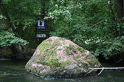
King Jagiełło's Stone is a natural landmark near Rudzki Most. | |
| Coordinates: 53°34′8.93″N 17°53′33.11″E / 53.5691472°N 17.8925306°E | |
| Country | |
| Voivodeship | Kuyavian-Pomeranian |
| County | Tuchola |
| Gmina | Tuchola |
| Town | Tuchola |
| Within town limits | 1955 |
| Time zone | UTC+1 ( CET) |
| • Summer ( DST) | UTC+2 ( CEST) |
| Vehicle registration | CTU |
Rudzki Most [ˈrut͡ski ˈmɔst] ( transl. Rudzki Bridge, German: Rudabrück/Raudenbrück) is a district of Tuchola, Poland, located in the south-eastern part of the town, along the west bank of the Brda River. [1] It is on the edge of the Tuchola Landscape Park, and was incorporated into the town limits and jurisdiction of Tuchola in 1955. The district takes its name from wooden bridge over the Brda, which was most recently replaced in 1958 by the current road bridge, part of route 240, and from the Ruda River, which flows through the nearby village of Rudzki Młyn.[ citation needed]
There is a launching point for canoeing on the Brda River, and in the river near the bridge is a notable large boulder called King Jagiełło's Stone, with a circumference about 7 metres (23 ft). [1] The Roman Catholic Parish of Divine Providence is located in the district as well.
German occupation

On October 24, 27 and 30, and on November 2, 6 and 10, 1939, at the beginning of the German occupation of Poland, Germans carried out mass shootings of local Poles, mainly of the intelligentsia as part of the larger Intelligenzaktion Pommern, in the surrounding forests. [2] [3] The priest Franciszek Nogalski attempted to negotiate the release of many those to be executed, but was ultimately killed himself. [4] In 1943 the German occupiers renamed the village Raudenbrück.[ citation needed]
After the war, in November 1946, the bones of 227 victims were exhumed, 34 of which were unidentified, and reburied in Tuchola, where a mausoleum was later built. There is now a monument at the site of the mass graves of the murdered. [3]
See also
References
- ^ a b "The District of Tuchola". City Hall in Tuchola. 2017. Retrieved July 31, 2017.
- ^ Markowski, Tymon; Boryga, Andrew (January 30, 2017). "Capturing Imaginative 'Strangeness' in Polish River Towns". The New York Times. Retrieved July 31, 2017.
- ^ a b "Excution Site Rudzki Most". Traces of War. 2017. Retrieved July 31, 2017.
- ^ Wardzyńska, Maria (2009). Był rok 1939. Operacja niemieckiej policji bezpieczeństwa w Polsce. Intelligenzaktion (in Polish). Warszawa: IPN. pp. 169–170. ISBN 978-83-7629-063-8
Rudzki Most | |
|---|---|
District of
Tuchola | |

King Jagiełło's Stone is a natural landmark near Rudzki Most. | |
| Coordinates: 53°34′8.93″N 17°53′33.11″E / 53.5691472°N 17.8925306°E | |
| Country | |
| Voivodeship | Kuyavian-Pomeranian |
| County | Tuchola |
| Gmina | Tuchola |
| Town | Tuchola |
| Within town limits | 1955 |
| Time zone | UTC+1 ( CET) |
| • Summer ( DST) | UTC+2 ( CEST) |
| Vehicle registration | CTU |
Rudzki Most [ˈrut͡ski ˈmɔst] ( transl. Rudzki Bridge, German: Rudabrück/Raudenbrück) is a district of Tuchola, Poland, located in the south-eastern part of the town, along the west bank of the Brda River. [1] It is on the edge of the Tuchola Landscape Park, and was incorporated into the town limits and jurisdiction of Tuchola in 1955. The district takes its name from wooden bridge over the Brda, which was most recently replaced in 1958 by the current road bridge, part of route 240, and from the Ruda River, which flows through the nearby village of Rudzki Młyn.[ citation needed]
There is a launching point for canoeing on the Brda River, and in the river near the bridge is a notable large boulder called King Jagiełło's Stone, with a circumference about 7 metres (23 ft). [1] The Roman Catholic Parish of Divine Providence is located in the district as well.
German occupation

On October 24, 27 and 30, and on November 2, 6 and 10, 1939, at the beginning of the German occupation of Poland, Germans carried out mass shootings of local Poles, mainly of the intelligentsia as part of the larger Intelligenzaktion Pommern, in the surrounding forests. [2] [3] The priest Franciszek Nogalski attempted to negotiate the release of many those to be executed, but was ultimately killed himself. [4] In 1943 the German occupiers renamed the village Raudenbrück.[ citation needed]
After the war, in November 1946, the bones of 227 victims were exhumed, 34 of which were unidentified, and reburied in Tuchola, where a mausoleum was later built. There is now a monument at the site of the mass graves of the murdered. [3]
See also
References
- ^ a b "The District of Tuchola". City Hall in Tuchola. 2017. Retrieved July 31, 2017.
- ^ Markowski, Tymon; Boryga, Andrew (January 30, 2017). "Capturing Imaginative 'Strangeness' in Polish River Towns". The New York Times. Retrieved July 31, 2017.
- ^ a b "Excution Site Rudzki Most". Traces of War. 2017. Retrieved July 31, 2017.
- ^ Wardzyńska, Maria (2009). Był rok 1939. Operacja niemieckiej policji bezpieczeństwa w Polsce. Intelligenzaktion (in Polish). Warszawa: IPN. pp. 169–170. ISBN 978-83-7629-063-8

