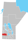
Rural Municipality of Rosedale | |
|---|---|
 Location of the RM of Rosedale in Manitoba | |
| Coordinates: 50°26′23″N 99°32′20″W / 50.43972°N 99.53889°W | |
| Country | Canada |
| Province | Manitoba |
| Area | |
| • Land | 864.55 km2 (333.80 sq mi) |
| Population | |
| • Total | 1,524 |
| Time zone | UTC-6 ( CST) |
| • Summer ( DST) | UTC-5 ( CDT) |
| Area codes | 204 and 431 |
Rosedale is a rural municipality (RM) in the province of Manitoba in Western Canada. The southeast corner of Riding Mountain National Park overlaps the northwest corner of the RM, and comprises about one-sixth of Rosedale's territory.[ citation needed] The Town of Neepawa borders the municipality.
Communities
Demographics
In the 2021 Census of Population conducted by Statistics Canada, Rosedale had a population of 1,524 living in 507 of its 587 total private dwellings, a change of -8.9% from its 2016 population of 1,672. With a land area of 864.68 km2 (333.85 sq mi), it had a population density of 1.8/km2 (4.6/sq mi) in 2021. [1]
Tourism
Mountain Road Hall hosts a spring and fall craft sale [2]
Churches
- Living Hope Fellowship Church – Eden
- Mountainview Church of God – Eden
- Kingdom Hall of Jehovah Witness – Kelwood
- St. John's Anglican Church – Kelwood
- St. Elizabeth's Roman Catholic Church – Polonia
- St. Mary's Ukrainian Catholic Church – Mountain Road (Ukrainian: Церква)
Monuments
- Big Valley School No. 2109
- Birnie Memorial Park
- Birnie Methodist Church
- Clarkesville School No. 1396
- Coldstream School No. 435
- Eden Consolidated School No. 1661
- Franklin School No. 780
- Iroquois School No. 303
- Kelwood Centennial Monument
- Kelwood War Memorial
- Kenilworth School / Riding Mountain School No. 1439
- Knox United Church
- Mountain Road School No. 1432
- Mountain Road Stores
- Mountain View School No. 244
- Patronage of the Blessed Virgin Mary Ukrainian Catholic Church
- Polonia School No. 732
- Riding Mountain War Memorial
- Roskeen School No. 1058
- Springhill Church
- Springhill School No. 374
- Tobarmore School No. 616
References
- ^ a b c "Population and dwelling counts: Canada, provinces and territories, and census subdivisions (municipalities), Manitoba". Statistics Canada. February 9, 2022. Retrieved February 20, 2022.
- ^ "Recreation | RM of Rosedale".
External links
Rural Municipality of Rosedale | |
|---|---|
 Location of the RM of Rosedale in Manitoba | |
| Coordinates: 50°26′23″N 99°32′20″W / 50.43972°N 99.53889°W | |
| Country | Canada |
| Province | Manitoba |
| Area | |
| • Land | 864.55 km2 (333.80 sq mi) |
| Population | |
| • Total | 1,524 |
| Time zone | UTC-6 ( CST) |
| • Summer ( DST) | UTC-5 ( CDT) |
| Area codes | 204 and 431 |
Rosedale is a rural municipality (RM) in the province of Manitoba in Western Canada. The southeast corner of Riding Mountain National Park overlaps the northwest corner of the RM, and comprises about one-sixth of Rosedale's territory.[ citation needed] The Town of Neepawa borders the municipality.
Communities
Demographics
In the 2021 Census of Population conducted by Statistics Canada, Rosedale had a population of 1,524 living in 507 of its 587 total private dwellings, a change of -8.9% from its 2016 population of 1,672. With a land area of 864.68 km2 (333.85 sq mi), it had a population density of 1.8/km2 (4.6/sq mi) in 2021. [1]
Tourism
Mountain Road Hall hosts a spring and fall craft sale [2]
Churches
- Living Hope Fellowship Church – Eden
- Mountainview Church of God – Eden
- Kingdom Hall of Jehovah Witness – Kelwood
- St. John's Anglican Church – Kelwood
- St. Elizabeth's Roman Catholic Church – Polonia
- St. Mary's Ukrainian Catholic Church – Mountain Road (Ukrainian: Церква)
Monuments
- Big Valley School No. 2109
- Birnie Memorial Park
- Birnie Methodist Church
- Clarkesville School No. 1396
- Coldstream School No. 435
- Eden Consolidated School No. 1661
- Franklin School No. 780
- Iroquois School No. 303
- Kelwood Centennial Monument
- Kelwood War Memorial
- Kenilworth School / Riding Mountain School No. 1439
- Knox United Church
- Mountain Road School No. 1432
- Mountain Road Stores
- Mountain View School No. 244
- Patronage of the Blessed Virgin Mary Ukrainian Catholic Church
- Polonia School No. 732
- Riding Mountain War Memorial
- Roskeen School No. 1058
- Springhill Church
- Springhill School No. 374
- Tobarmore School No. 616
References
- ^ a b c "Population and dwelling counts: Canada, provinces and territories, and census subdivisions (municipalities), Manitoba". Statistics Canada. February 9, 2022. Retrieved February 20, 2022.
- ^ "Recreation | RM of Rosedale".
