Photos • Location
Rohrdorf | |
|---|---|
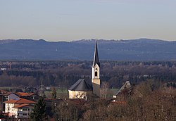
 Church of Saint James the Elder | |
Location of Rohrdorf within Rosenheim district  | |
| Coordinates: 47°47′56″N 12°10′3″E / 47.79889°N 12.16750°E | |
| Country | Germany |
| State | Bavaria |
| Admin. region | Oberbayern |
| District | Rosenheim |
| Subdivisions | 5 Ortsteile |
| Government | |
| • Mayor (2020–26) | Simon Hausstetter [1] |
| Area | |
| • Total | 28.67 km2 (11.07 sq mi) |
| Elevation | 476 m (1,562 ft) |
| Population (2022-12-31)
[2] | |
| • Total | 5,965 |
| • Density | 210/km2 (540/sq mi) |
| Time zone | UTC+01:00 ( CET) |
| • Summer ( DST) | UTC+02:00 ( CEST) |
| Postal codes | 83101 |
| Dialling codes | 08031, 08032 |
| Vehicle registration | RO |
| Website | www.rohrdorf.de |
Rohrdorf ( Central Bavarian: Roudarf) is a municipality in the district of Rosenheim in Upper Bavaria, Germany. It is located in the Inn valley.
Rohrdorf was first mentioned in 788 in the notitia arnonis.
Evidence of prehistoric settlement in the village has been found.
During World War II, a subcamp of Dachau concentration camp was located here. [3]
-
 Rosate, Italy
 -
 Schattendorf, Austria
 -
 Tarnowo Podgórne, Poland
- ^ Liste der ersten Bürgermeister/Oberbürgermeister in kreisangehörigen Gemeinden, Bayerisches Landesamt für Statistik, 15 July 2021.
- ^ Genesis Online-Datenbank des Bayerischen Landesamtes für Statistik Tabelle 12411-003r Fortschreibung des Bevölkerungsstandes: Gemeinden, Stichtag (Einwohnerzahlen auf Grundlage des Zensus 2011).
- ^ "Linde, Land Nordrhein-Westfalen, Germany - Pages - glosk". Archived from the original on 2009-02-09. Retrieved 2008-11-01.
Rohrdorf | |
|---|---|
 Church of Saint James the Elder | |
Location of Rohrdorf within Rosenheim district  | |
| Coordinates: 47°47′56″N 12°10′3″E / 47.79889°N 12.16750°E | |
| Country | Germany |
| State | Bavaria |
| Admin. region | Oberbayern |
| District | Rosenheim |
| Subdivisions | 5 Ortsteile |
| Government | |
| • Mayor (2020–26) | Simon Hausstetter [1] |
| Area | |
| • Total | 28.67 km2 (11.07 sq mi) |
| Elevation | 476 m (1,562 ft) |
| Population (2022-12-31)
[2] | |
| • Total | 5,965 |
| • Density | 210/km2 (540/sq mi) |
| Time zone | UTC+01:00 ( CET) |
| • Summer ( DST) | UTC+02:00 ( CEST) |
| Postal codes | 83101 |
| Dialling codes | 08031, 08032 |
| Vehicle registration | RO |
| Website | www.rohrdorf.de |
Rohrdorf ( Central Bavarian: Roudarf) is a municipality in the district of Rosenheim in Upper Bavaria, Germany. It is located in the Inn valley.
Rohrdorf was first mentioned in 788 in the notitia arnonis.
Evidence of prehistoric settlement in the village has been found.
During World War II, a subcamp of Dachau concentration camp was located here. [3]
-
 Rosate, Italy
 -
 Schattendorf, Austria
 -
 Tarnowo Podgórne, Poland
- ^ Liste der ersten Bürgermeister/Oberbürgermeister in kreisangehörigen Gemeinden, Bayerisches Landesamt für Statistik, 15 July 2021.
- ^ Genesis Online-Datenbank des Bayerischen Landesamtes für Statistik Tabelle 12411-003r Fortschreibung des Bevölkerungsstandes: Gemeinden, Stichtag (Einwohnerzahlen auf Grundlage des Zensus 2011).
- ^ "Linde, Land Nordrhein-Westfalen, Germany - Pages - glosk". Archived from the original on 2009-02-09. Retrieved 2008-11-01.


