Photos • Location
| Rockhouse Falls | |
|---|---|
 Rockhouse Falls | |
|
| |
| Location | Spencer, Tennessee |
| Coordinates | 35°39′47″N 85°20′59″W / 35.663023°N 85.349783°W |
| Type | Plunge |
| Total height | 125 feet (38 m) |
| Watercourse | Rockhouse Creek |
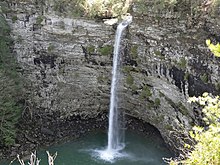
Rockhouse Falls, is a 125 feet (38 m) plunge waterfall that marks Rockhouse Creek's confluence with Cane Creek. The waterfall, which shares a plungepool with Cane Creek Falls, is visible from the Gorge Trail and from the base of the Cane Creek Gorge. The falls are located near Spencer, Tennessee in Fall Creek Falls State Park. [1]
References
- ^ Manning, Russ (2000). 40 Hikes in Tennessee's South Cumberland (3rd ed.). Seattle, WA: Mountaineers. p. 87. ISBN 978-0-89886-637-7.
| Rockhouse Falls | |
|---|---|
 Rockhouse Falls | |
|
| |
| Location | Spencer, Tennessee |
| Coordinates | 35°39′47″N 85°20′59″W / 35.663023°N 85.349783°W |
| Type | Plunge |
| Total height | 125 feet (38 m) |
| Watercourse | Rockhouse Creek |
Rockhouse Falls, is a 125 feet (38 m) plunge waterfall that marks Rockhouse Creek's confluence with Cane Creek. The waterfall, which shares a plungepool with Cane Creek Falls, is visible from the Gorge Trail and from the base of the Cane Creek Gorge. The falls are located near Spencer, Tennessee in Fall Creek Falls State Park. [1]
References
- ^ Manning, Russ (2000). 40 Hikes in Tennessee's South Cumberland (3rd ed.). Seattle, WA: Mountaineers. p. 87. ISBN 978-0-89886-637-7.