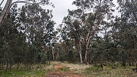
| Ringwood Tank State Forest | |
|---|---|
 | |
| Geography | |
| Location | South Western Slopes, New South Wales, Australia |
| Coordinates | 35°55′21″S 146°16′48″E / 35.92250°S 146.28000°E |
| Area | 231 ha (2.3 km2; 0.9 sq mi) |
| Administration | |
| Governing body | Forestry Corporation of NSW [1] |
| Ecology | |
| Dominant tree species | White cypress pine [2] |
| Lesser flora | Grey box [2] |
Ringwood Tank State Forest is a native forest, located in the South Western Slopes region of New South Wales, in eastern Australia. The 231 ha (570-acre) [2] state forest is located approximately 12 km (7.5 mi) north-west of Corowa. [3]
Etymology
The place name Ringwood Tank is derived from the dam located in the northern section of the reserve. [4]
Environment
Ringwood Tank State Forest is dominated by white cypress pine. [2] Other plant species present within the forest include grey box and bulloak. [2]
At least six species listed under the Biodiversity Conservation Act 2016 have been recorded within the state forest, [2] including squirrel glider, brolga, brown treecreeper, grey-crowned babbler, hooded robin, and varied sittella. [2]
See also
References
- ^ "NSW State Forests" (PDF). Forestry Corporation. 17 March 2014. Archived (PDF) from the original on 5 March 2023. Retrieved 2 July 2024.
- ^ a b c d e f g "Regional Forest Assessment: South-western cypress state forests" (PDF). Natural Resources Commission. Archived (PDF) from the original on 14 March 2023. Retrieved 2 July 2024.
- ^ "Forests NSW forest management zones - Riverina Region" (PDF). Forestry Corporation of NSW. January 2008. Archived (PDF) from the original on 7 March 2023. Retrieved 2 July 2024.
- ^ "Ringwood Tank". Geographical Names Board of New South Wales. Archived from the original on 3 July 2024. Retrieved 2 July 2024.
| Ringwood Tank State Forest | |
|---|---|
 | |
| Geography | |
| Location | South Western Slopes, New South Wales, Australia |
| Coordinates | 35°55′21″S 146°16′48″E / 35.92250°S 146.28000°E |
| Area | 231 ha (2.3 km2; 0.9 sq mi) |
| Administration | |
| Governing body | Forestry Corporation of NSW [1] |
| Ecology | |
| Dominant tree species | White cypress pine [2] |
| Lesser flora | Grey box [2] |
Ringwood Tank State Forest is a native forest, located in the South Western Slopes region of New South Wales, in eastern Australia. The 231 ha (570-acre) [2] state forest is located approximately 12 km (7.5 mi) north-west of Corowa. [3]
Etymology
The place name Ringwood Tank is derived from the dam located in the northern section of the reserve. [4]
Environment
Ringwood Tank State Forest is dominated by white cypress pine. [2] Other plant species present within the forest include grey box and bulloak. [2]
At least six species listed under the Biodiversity Conservation Act 2016 have been recorded within the state forest, [2] including squirrel glider, brolga, brown treecreeper, grey-crowned babbler, hooded robin, and varied sittella. [2]
See also
References
- ^ "NSW State Forests" (PDF). Forestry Corporation. 17 March 2014. Archived (PDF) from the original on 5 March 2023. Retrieved 2 July 2024.
- ^ a b c d e f g "Regional Forest Assessment: South-western cypress state forests" (PDF). Natural Resources Commission. Archived (PDF) from the original on 14 March 2023. Retrieved 2 July 2024.
- ^ "Forests NSW forest management zones - Riverina Region" (PDF). Forestry Corporation of NSW. January 2008. Archived (PDF) from the original on 7 March 2023. Retrieved 2 July 2024.
- ^ "Ringwood Tank". Geographical Names Board of New South Wales. Archived from the original on 3 July 2024. Retrieved 2 July 2024.