Rice Covered Bridge | |
 Rice Covered Bridge, October 2010 | |
  | |
| Location | South of Landisburg on Legislative Route 50023, Tyrone Township, Pennsylvania |
|---|---|
| Coordinates | 40°20′9″N 77°18′34″W / 40.33583°N 77.30944°W |
| Area | 0.1 acres (0.040 ha) |
| Built | 1869 |
| Architectural style | Burr, Queen Post |
| MPS | Covered Bridges of Adams, Cumberland, and Perry Counties TR |
| NRHP reference No. | 80003596 [1] |
| Added to NRHP | August 25, 1980 |
The Rice Covered Bridge, also known as the Landisburg Covered Bridge, is an historic, American wooden covered bridge that is located in Tyrone Township near Landisburg in Perry County, Pennsylvania.
It was listed on the National Register of Historic Places in 1980. [1]
History and architectural features
This historic structure is a 123-foot-long (37 m) combination Burr truss and queen post bridge, constructed in 1869. It crosses Shermans Creek. Its WGCB reference is 38-50-10. [2]
It was listed on the National Register of Historic Places in 1980. [1]
Gallery
-
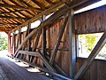 Interior, showing the rare combination of queen post and Burr arch trusses

References
- ^ a b c "National Register Information System". National Register of Historic Places. National Park Service. March 13, 2009.
- ^ Susan M. Zacher (March 10, 1980). "National Register of Historic Places Inventory — Nomination Form: Rice Covered Bridge" (PDF). Pennsylvania Historical and Museum Commission. Retrieved 2011-11-20.

- Covered bridges on the National Register of Historic Places in Pennsylvania
- Covered bridges in Perry County, Pennsylvania
- Bridges completed in 1869
- Wooden bridges in Pennsylvania
- Bridges in Perry County, Pennsylvania
- Tourist attractions in Perry County, Pennsylvania
- 1869 establishments in Pennsylvania
- National Register of Historic Places in Perry County, Pennsylvania
- Road bridges on the National Register of Historic Places in Pennsylvania
- Burr Truss bridges in the United States
Rice Covered Bridge | |
|
Rice Covered Bridge, October 2010 | |
| |
| Location | South of Landisburg on Legislative Route 50023, Tyrone Township, Pennsylvania |
|---|---|
| Coordinates | 40°20′9″N 77°18′34″W / 40.33583°N 77.30944°W |
| Area | 0.1 acres (0.040 ha) |
| Built | 1869 |
| Architectural style | Burr, Queen Post |
| MPS | Covered Bridges of Adams, Cumberland, and Perry Counties TR |
| NRHP reference No. | 80003596 [1] |
| Added to NRHP | August 25, 1980 |
The Rice Covered Bridge, also known as the Landisburg Covered Bridge, is an historic, American wooden covered bridge that is located in Tyrone Township near Landisburg in Perry County, Pennsylvania.
It was listed on the National Register of Historic Places in 1980. [1]
History and architectural features
This historic structure is a 123-foot-long (37 m) combination Burr truss and queen post bridge, constructed in 1869. It crosses Shermans Creek. Its WGCB reference is 38-50-10. [2]
It was listed on the National Register of Historic Places in 1980. [1]
Gallery
-
Interior, showing the rare combination of queen post and Burr arch trusses
References
- ^ a b c "National Register Information System". National Register of Historic Places. National Park Service. March 13, 2009.
- ^ Susan M. Zacher (March 10, 1980). "National Register of Historic Places Inventory — Nomination Form: Rice Covered Bridge" (PDF). Pennsylvania Historical and Museum Commission. Retrieved 2011-11-20.
- Covered bridges on the National Register of Historic Places in Pennsylvania
- Covered bridges in Perry County, Pennsylvania
- Bridges completed in 1869
- Wooden bridges in Pennsylvania
- Bridges in Perry County, Pennsylvania
- Tourist attractions in Perry County, Pennsylvania
- 1869 establishments in Pennsylvania
- National Register of Historic Places in Perry County, Pennsylvania
- Road bridges on the National Register of Historic Places in Pennsylvania
- Burr Truss bridges in the United States