| Ribat of Lamta رباط لمطة | |
|---|---|
| Lamta, Tunisia | |
 View from outside | |
| Type | Aghlabid Ribat |
| Site history | |
| Built | 9th century |
| Built by | Abu Ibrahim Ahmad ibn Muhammad |
| Materials | stone |
Ribat of Lamta رباط لمطة is a small Aghlabid ribat in the coastal town of Lamta, Tunisia. The building was constructed in 859 (corresponding to 245 AH) by the Aghlabid prince Abu Ibrahim Ahmad ibn Muhammad. [1]
It consists of a square, single-storey building with rounded towers at the corners. The entrance to the ribat is via a single main entrance that opens onto a straight corridor leading to a central courtyard, where travelers could seek refuge to rest. The central courtyard, which features an underground water reservoir, is surrounded by several small rooms. [2]
Many soldier-monks stayed in the ribat, including: [3]
- Abu al-Sari Wassel al-Jami (Arabic: أبو السري واصل الجمي);
- Abu Bakr al-Qurashi al-Saqili (Arabic: أبو بكر القرشي الصقلي), one of Yahya Ibn Omar's companions;
- Abu Haroun al-Andalusi (Arabic: أبو هارون الأندلسي), died in 903 (291 A.H.) in Lamta.
On 21 January 2021, an order from the Ministry of Culture made it a protected monument identified by ID 52–8. [4]
-
 Interior of the ribat
 -
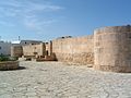 Exterior of the ribat
 -
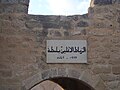 Plaque at the entrance
 -
 Main Entrance of the ribat
 -
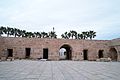 Ribat's courtyard


- ^ Rammah, Mourad (2010). Ribat cities in Ifriqiya 13 centuries of art and architecture in Tunisia (in French). Vienna: Museum with No Frontiers. pp. 184–201.
- ^ Jalloul, Néji (1999). Fortifications in Tunisia (in French). Tunis: Agency for the development heritage and cultural promotion. p. 51. ISBN 9789973917331.
- ^ Jalloul, Néji (1999). Maritime fortifications in medieval Ifriqiya (in Arabic). Tunis: Centre for Economic and Social Studies and Research. p. 119. ISBN 9973902068.
- ^ "Order of the Acting Minister for Cultural Affairs of 21 January 2021 on the protection of historical and archaeological monuments" (PDF). Official Journal of the Republic of Tunisia. 29 January 2021. Retrieved 23 July 2023.
| Ribat of Lamta رباط لمطة | |
|---|---|
| Lamta, Tunisia | |
|
View from outside | |
| Type | Aghlabid Ribat |
| Site history | |
| Built | 9th century |
| Built by | Abu Ibrahim Ahmad ibn Muhammad |
| Materials | stone |
Ribat of Lamta رباط لمطة is a small Aghlabid ribat in the coastal town of Lamta, Tunisia. The building was constructed in 859 (corresponding to 245 AH) by the Aghlabid prince Abu Ibrahim Ahmad ibn Muhammad. [1]
It consists of a square, single-storey building with rounded towers at the corners. The entrance to the ribat is via a single main entrance that opens onto a straight corridor leading to a central courtyard, where travelers could seek refuge to rest. The central courtyard, which features an underground water reservoir, is surrounded by several small rooms. [2]
Many soldier-monks stayed in the ribat, including: [3]
- Abu al-Sari Wassel al-Jami (Arabic: أبو السري واصل الجمي);
- Abu Bakr al-Qurashi al-Saqili (Arabic: أبو بكر القرشي الصقلي), one of Yahya Ibn Omar's companions;
- Abu Haroun al-Andalusi (Arabic: أبو هارون الأندلسي), died in 903 (291 A.H.) in Lamta.
On 21 January 2021, an order from the Ministry of Culture made it a protected monument identified by ID 52–8. [4]
-
Interior of the ribat
-
Exterior of the ribat
-
Plaque at the entrance
-
Main Entrance of the ribat
-
Ribat's courtyard
- ^ Rammah, Mourad (2010). Ribat cities in Ifriqiya 13 centuries of art and architecture in Tunisia (in French). Vienna: Museum with No Frontiers. pp. 184–201.
- ^ Jalloul, Néji (1999). Fortifications in Tunisia (in French). Tunis: Agency for the development heritage and cultural promotion. p. 51. ISBN 9789973917331.
- ^ Jalloul, Néji (1999). Maritime fortifications in medieval Ifriqiya (in Arabic). Tunis: Centre for Economic and Social Studies and Research. p. 119. ISBN 9973902068.
- ^ "Order of the Acting Minister for Cultural Affairs of 21 January 2021 on the protection of historical and archaeological monuments" (PDF). Official Journal of the Republic of Tunisia. 29 January 2021. Retrieved 23 July 2023.