Photos • Location
The Rhuys Peninsula forms the southern boundary coast of the
Gulf of Morbihan.

This article needs additional citations for
verification. (July 2008) |

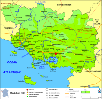
The Rhuys Peninsula ( Breton: Gourenez Rewiz, French: Presqu'île de Rhuys) is located in the département of Morbihan in the region of Brittany in northwestern France.
Three communes are located on the peninsula:
- Sarzeau, the largest, covering 50% of the area of the peninsula
- Arzon
- Saint-Gildas-de-Rhuys
History
47°31′N 2°47′W / 47.517°N 2.783°W
| International | |
|---|---|
| National | |
This article needs additional citations for
verification. (July 2008) |
The Rhuys Peninsula ( Breton: Gourenez Rewiz, French: Presqu'île de Rhuys) is located in the département of Morbihan in the region of Brittany in northwestern France.
Three communes are located on the peninsula:
- Sarzeau, the largest, covering 50% of the area of the peninsula
- Arzon
- Saint-Gildas-de-Rhuys
History
47°31′N 2°47′W / 47.517°N 2.783°W
| International | |
|---|---|
| National | |