PhotosLocation


retzow Latitude and Longitude:

52°38′N 12°42′E / 52.633°N 12.700°E / 52.633; 12.700
From Wikipedia, the free encyclopedia
Retzow
Location of Retzow within Havelland district
Brieselang Dallgow-Döberitz Falkensee Friesack Gollenberg Großderschau Havelaue Ketzin Kleßen-Görne Kotzen Märkisch Luch Milower Land Mühlenberge Nauen Nennhausen Paulinenaue Pessin Premnitz Rathenow Retzow Rhinow Schönwalde-Glien Seeblick Stechow-Ferchesar Wiesenaue Wustermark Brandenburg
Retzow is located in Germany
Retzow
Retzow
Retzow is located in Brandenburg
Retzow
Retzow
Coordinates: 52°38′N 12°42′E / 52.633°N 12.700°E / 52.633; 12.700
Country Germany
State Brandenburg
District Havelland
Municipal assoc. Friesack
Government
 •  Mayor (2024–29) Christian Link [1]
Area
 • Total14.73 km2 (5.69 sq mi)
Elevation
39 m (128 ft)
Population
 (2022-12-31) [2]
 • Total522
 • Density35/km2 (92/sq mi)
Time zone UTC+01:00 ( CET)
 • Summer ( DST) UTC+02:00 ( CEST)
Postal codes
14641
Dialling codes033237
Vehicle registrationHVL
Website www.amt-friesack.de

Retzow is a municipality in the Havelland district, in Brandenburg, Germany.

Demography

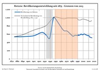
Development of population since 1875 within the current boundaries (Blue line: Population; Dotted line: Comparison to population development of Brandenburg state; Grey background: Time of Nazi rule; Red background: Time of communist rule)
Retzow: Population development
within the current boundaries (2013) [3]
Year Pop. ±% p.a.
1875 537—    
1890 540+0.04%
1910 562+0.20%
1925 642+0.89%
1933 573−1.41%
1939 503−2.15%
1946 1,000+10.31%
1950 966−0.86%
1964 696−2.31%
1971 675−0.44%
1981 554−1.96%
1985 573+0.85%
1989 569−0.17%
1990 563−1.05%
1991 584+3.73%
1992 569−2.57%
1993 577+1.41%
1994 582+0.87%
1995 588+1.03%
1996 603+2.55%
Year Pop. ±% p.a.
1997 600−0.50%
1998 587−2.17%
1999 586−0.17%
2000 586+0.00%
2001 600+2.39%
2002 606+1.00%
2003 602−0.66%
2004 591−1.83%
2005 585−1.02%
2006 580−0.85%
2007 573−1.21%
2008 571−0.35%
2009 562−1.58%
2010 568+1.07%
2011 552−2.82%
2012 527−4.53%
2013 529+0.38%
2014 518−2.08%
2015 518+0.00%
2016 511−1.35%

References

  1. ^ Landkreis Havelland Wahl der Bürgermeisterin / des Bürgermeisters. Retrieved 10 July 2024.
  2. ^ "Bevölkerungsentwicklung und Bevölkerungsstandim Land Brandenburg Dezember 2022" (PDF). Amt für Statistik Berlin-Brandenburg (in German). June 2023.
  3. ^ Detailed data sources are to be found in the Wikimedia Commons. Population Projection Brandenburg at Wikimedia Commons


retzow Latitude and Longitude:

52°38′N 12°42′E / 52.633°N 12.700°E / 52.633; 12.700
From Wikipedia, the free encyclopedia
Retzow
Location of Retzow within Havelland district
Brieselang Dallgow-Döberitz Falkensee Friesack Gollenberg Großderschau Havelaue Ketzin Kleßen-Görne Kotzen Märkisch Luch Milower Land Mühlenberge Nauen Nennhausen Paulinenaue Pessin Premnitz Rathenow Retzow Rhinow Schönwalde-Glien Seeblick Stechow-Ferchesar Wiesenaue Wustermark Brandenburg
Retzow is located in Germany
Retzow
Retzow
Retzow is located in Brandenburg
Retzow
Retzow
Coordinates: 52°38′N 12°42′E / 52.633°N 12.700°E / 52.633; 12.700
Country Germany
State Brandenburg
District Havelland
Municipal assoc. Friesack
Government
 •  Mayor (2024–29) Christian Link [1]
Area
 • Total14.73 km2 (5.69 sq mi)
Elevation
39 m (128 ft)
Population
 (2022-12-31) [2]
 • Total522
 • Density35/km2 (92/sq mi)
Time zone UTC+01:00 ( CET)
 • Summer ( DST) UTC+02:00 ( CEST)
Postal codes
14641
Dialling codes033237
Vehicle registrationHVL
Website www.amt-friesack.de

Retzow is a municipality in the Havelland district, in Brandenburg, Germany.

Demography

Development of population since 1875 within the current boundaries (Blue line: Population; Dotted line: Comparison to population development of Brandenburg state; Grey background: Time of Nazi rule; Red background: Time of communist rule)
Retzow: Population development
within the current boundaries (2013) [3]
Year Pop. ±% p.a.
1875 537—    
1890 540+0.04%
1910 562+0.20%
1925 642+0.89%
1933 573−1.41%
1939 503−2.15%
1946 1,000+10.31%
1950 966−0.86%
1964 696−2.31%
1971 675−0.44%
1981 554−1.96%
1985 573+0.85%
1989 569−0.17%
1990 563−1.05%
1991 584+3.73%
1992 569−2.57%
1993 577+1.41%
1994 582+0.87%
1995 588+1.03%
1996 603+2.55%
Year Pop. ±% p.a.
1997 600−0.50%
1998 587−2.17%
1999 586−0.17%
2000 586+0.00%
2001 600+2.39%
2002 606+1.00%
2003 602−0.66%
2004 591−1.83%
2005 585−1.02%
2006 580−0.85%
2007 573−1.21%
2008 571−0.35%
2009 562−1.58%
2010 568+1.07%
2011 552−2.82%
2012 527−4.53%
2013 529+0.38%
2014 518−2.08%
2015 518+0.00%
2016 511−1.35%

References

  1. ^ Landkreis Havelland Wahl der Bürgermeisterin / des Bürgermeisters. Retrieved 10 July 2024.
  2. ^ "Bevölkerungsentwicklung und Bevölkerungsstandim Land Brandenburg Dezember 2022" (PDF). Amt für Statistik Berlin-Brandenburg (in German). June 2023.
  3. ^ Detailed data sources are to be found in the Wikimedia Commons. Population Projection Brandenburg at Wikimedia Commons


Videos

Youtube | Vimeo | Bing

Websites

Google | Yahoo | Bing

Encyclopedia

Google | Yahoo | Bing

Facebook