Reeuwijk-Dorp | |
|---|---|
Village | |
 | |
 Reeuwijk-Dorp Location in the province of South Holland in the Netherlands  Reeuwijk-Dorp Location in the Netherlands | |
| Coordinates: 52°03′18″N 4°41′27″E / 52.05500°N 4.69083°E | |
| Country | Netherlands |
| Province | South Holland |
| Municipality | Bodegraven-Reeuwijk |
| Area | |
| • Total | 11.45 km2 (4.42 sq mi) |
| Elevation | −1.5 m (−4.9 ft) |
| Population (2021)
[1] | |
| • Total | 1,995 |
| • Density | 170/km2 (450/sq mi) |
| Time zone | UTC+1 ( CET) |
| • Summer ( DST) | UTC+2 ( CEST) |
| Postal code | 2811
[1] |
| Dialing code | 0182 |
Reeuwijk-Dorp is a village in the Dutch province of South Holland. It is part of what used to be the municipality of Reeuwijk. It lies about 5 km north of Gouda. "Dorp" is Dutch for village, the name distinguishes from Reeuwijk-Brug which is situated 3 km to the east.
Reeuwijk-Drop is a stretched out peat excavation village from the Middle Ages. The Catholic St Paul and Peter Church is a Gothic Revival church built between 1889 and 1890. It is characterised by its short nave. [3]
Reeuwijk-Dorp was originally the main village, however the Reeuwijk-Brug was more strategically located and became the seat of the municipality from the mid-19th century onwards. In 2011, the municipality was merged into Bodegraven-Reeuwijk. [4]
-
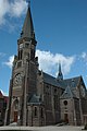 St Paul and Peter church
 -
 Clergy house
 -
 Canal view


- ^ a b c "Kerncijfers wijken en buurten 2021". Central Bureau of Statistics. Retrieved 3 May 2022.
- ^ "Postcodetool for 2811AA". Actueel Hoogtebestand Nederland (in Dutch). Het Waterschapshuis. 24 July 2019. Retrieved 3 May 2022.
- ^ Ronald Stenvert & Sabine Broekhoven (2004). "Reeuwijk-Dorp" (in Dutch). Zwolle: Waanders. ISBN 90-400-9034-3. Retrieved 3 May 2022.
- ^ "Reeuwijk-Dorp". Plaatsengids (in Dutch). Retrieved 3 May 2022.
| Authority control databases: Geographic |
|---|
|
| This South Holland location article is a stub. You can help Wikipedia by expanding it. |
Reeuwijk-Dorp | |
|---|---|
Village | |
|
| |
Reeuwijk-Dorp Location in the province of South Holland in the Netherlands Reeuwijk-Dorp Location in the Netherlands | |
| Coordinates: 52°03′18″N 4°41′27″E / 52.05500°N 4.69083°E | |
| Country | Netherlands |
| Province | South Holland |
| Municipality | Bodegraven-Reeuwijk |
| Area | |
| • Total | 11.45 km2 (4.42 sq mi) |
| Elevation | −1.5 m (−4.9 ft) |
| Population (2021)
[1] | |
| • Total | 1,995 |
| • Density | 170/km2 (450/sq mi) |
| Time zone | UTC+1 ( CET) |
| • Summer ( DST) | UTC+2 ( CEST) |
| Postal code | 2811
[1] |
| Dialing code | 0182 |
Reeuwijk-Dorp is a village in the Dutch province of South Holland. It is part of what used to be the municipality of Reeuwijk. It lies about 5 km north of Gouda. "Dorp" is Dutch for village, the name distinguishes from Reeuwijk-Brug which is situated 3 km to the east.
Reeuwijk-Drop is a stretched out peat excavation village from the Middle Ages. The Catholic St Paul and Peter Church is a Gothic Revival church built between 1889 and 1890. It is characterised by its short nave. [3]
Reeuwijk-Dorp was originally the main village, however the Reeuwijk-Brug was more strategically located and became the seat of the municipality from the mid-19th century onwards. In 2011, the municipality was merged into Bodegraven-Reeuwijk. [4]
-
St Paul and Peter church
-
Clergy house
-
Canal view
- ^ a b c "Kerncijfers wijken en buurten 2021". Central Bureau of Statistics. Retrieved 3 May 2022.
- ^ "Postcodetool for 2811AA". Actueel Hoogtebestand Nederland (in Dutch). Het Waterschapshuis. 24 July 2019. Retrieved 3 May 2022.
- ^ Ronald Stenvert & Sabine Broekhoven (2004). "Reeuwijk-Dorp" (in Dutch). Zwolle: Waanders. ISBN 90-400-9034-3. Retrieved 3 May 2022.
- ^ "Reeuwijk-Dorp". Plaatsengids (in Dutch). Retrieved 3 May 2022.
| Authority control databases: Geographic |
|---|
|
| This South Holland location article is a stub. You can help Wikipedia by expanding it. |