Photos • Location

Red Level, Alabama | |
|---|---|
 Red Level  Red Level | |
| Coordinates: 32°08′04″N 86°13′24″W / 32.13444°N 86.22333°W | |
| Country | United States |
| State | Alabama |
| County | Montgomery |
| Elevation | 344 ft (105 m) |
| Time zone | UTC-6 ( Central (CST)) |
| • Summer ( DST) | UTC-5 (CDT) |
| Area code | 334 |
| GNIS feature ID | 156949 [1] |
Red Level is an unincorporated community in Montgomery County, Alabama, United States. [1]
Notes
Municipalities and communities of
Montgomery County, Alabama, United States | ||
|---|---|---|
| Cities | 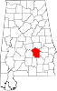 | |
| Towns | ||
|
Unincorporated communities | ||
| Indian reservation | ||
| Footnotes | ‡This populated place also has portions in an adjacent county or counties | |
|
| This Montgomery County, Alabama state location article is a stub. You can help Wikipedia by expanding it. |
Red Level, Alabama | |
|---|---|
Red Level Red Level | |
| Coordinates: 32°08′04″N 86°13′24″W / 32.13444°N 86.22333°W | |
| Country | United States |
| State | Alabama |
| County | Montgomery |
| Elevation | 344 ft (105 m) |
| Time zone | UTC-6 ( Central (CST)) |
| • Summer ( DST) | UTC-5 (CDT) |
| Area code | 334 |
| GNIS feature ID | 156949 [1] |
Red Level is an unincorporated community in Montgomery County, Alabama, United States. [1]
Notes
Municipalities and communities of
Montgomery County, Alabama, United States | ||
|---|---|---|
| Cities | | |
| Towns | ||
|
Unincorporated communities | ||
| Indian reservation | ||
| Footnotes | ‡This populated place also has portions in an adjacent county or counties | |
|
| This Montgomery County, Alabama state location article is a stub. You can help Wikipedia by expanding it. |