Photos • Location

Red Bush, Kentucky | |
|---|---|
 Red Bush, Kentucky | |
| Coordinates: 38°11′01″N 83°41′02″W / 38.18361°N 83.68389°W | |
| Country | United States |
| State | Kentucky |
| County | Bath |
| Elevation | 814 ft (248 m) |
| Time zone | UTC-5 ( Eastern (EST)) |
| • Summer ( DST) | UTC-4 (EDT) |
| Area code | 606 |
| GNIS feature ID | 2416488 [1] |
Red Bush is an unincorporated community in Bath County, Kentucky, United States. Red Bush is located on Water Dell Road 5.1 miles (8.2 km) east-northeast of Owingsville. [2]
- ^ "Red Bush". Geographic Names Information System. United States Geological Survey, United States Department of the Interior.
- ^ State Primary Road System: Bath County (PDF) (Map). Kentucky Transportation Cabinet. 2011. Retrieved June 11, 2012.
Municipalities and communities of
Bath County, Kentucky, United States | ||
|---|---|---|
| Cities | 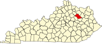 | |
|
Unincorporated communities | ||
|
| This Bath County, Kentucky state location article is a stub. You can help Wikipedia by expanding it. |
Red Bush, Kentucky | |
|---|---|
Red Bush, Kentucky | |
| Coordinates: 38°11′01″N 83°41′02″W / 38.18361°N 83.68389°W | |
| Country | United States |
| State | Kentucky |
| County | Bath |
| Elevation | 814 ft (248 m) |
| Time zone | UTC-5 ( Eastern (EST)) |
| • Summer ( DST) | UTC-4 (EDT) |
| Area code | 606 |
| GNIS feature ID | 2416488 [1] |
Red Bush is an unincorporated community in Bath County, Kentucky, United States. Red Bush is located on Water Dell Road 5.1 miles (8.2 km) east-northeast of Owingsville. [2]
- ^ "Red Bush". Geographic Names Information System. United States Geological Survey, United States Department of the Interior.
- ^ State Primary Road System: Bath County (PDF) (Map). Kentucky Transportation Cabinet. 2011. Retrieved June 11, 2012.
Municipalities and communities of
Bath County, Kentucky, United States | ||
|---|---|---|
| Cities | | |
|
Unincorporated communities | ||
|
| This Bath County, Kentucky state location article is a stub. You can help Wikipedia by expanding it. |