Photos • Location

the railway station

Re | |
|---|---|
| Comune di Re | |
 Re | |
| Coordinates: 46°08′N 08°30′E / 46.133°N 8.500°E | |
| Country | Italy |
| Region | Piedmont |
| Province | Verbano Cusio Ossola (VB) |
| Area | |
| • Total | 27 km2 (10 sq mi) |
| Population (2018-01-01)
[2] | |
| • Total | 830 |
| • Density | 31/km2 (80/sq mi) |
| Time zone | UTC+1 ( CET) |
| • Summer ( DST) | UTC+2 ( CEST) |
| Postal code | 28030 |
| Website | Official website |

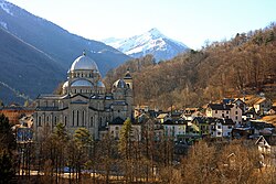
Re (Italian pronunciation: [rɛ]) is a village and comune in the Province of Verbano-Cusio-Ossola, in the region of Piedmont, Italy, approximately 20 kilometres (12 mi) from Domodossola and 7 kilometres (4 mi) from the border with Switzerland. It is situated on the Domodossola-Locarno railway and is home to a pilgrimage church.
External links
Wikimedia Commons has media related to
Re (VB).
- Re centro di turismo religioso Re Religious Tourism Website
- ^ "Superficie di Comuni Province e Regioni italiane al 9 ottobre 2011". Italian National Institute of Statistics. Retrieved 16 March 2019.
- ^ "Popolazione Residente al 1° Gennaio 2018". Italian National Institute of Statistics. Retrieved 16 March 2019.
Re | |
|---|---|
| Comune di Re | |
 Re | |
| Coordinates: 46°08′N 08°30′E / 46.133°N 8.500°E | |
| Country | Italy |
| Region | Piedmont |
| Province | Verbano Cusio Ossola (VB) |
| Area | |
| • Total | 27 km2 (10 sq mi) |
| Population (2018-01-01)
[2] | |
| • Total | 830 |
| • Density | 31/km2 (80/sq mi) |
| Time zone | UTC+1 ( CET) |
| • Summer ( DST) | UTC+2 ( CEST) |
| Postal code | 28030 |
| Website | Official website |

Re (Italian pronunciation: [rɛ]) is a village and comune in the Province of Verbano-Cusio-Ossola, in the region of Piedmont, Italy, approximately 20 kilometres (12 mi) from Domodossola and 7 kilometres (4 mi) from the border with Switzerland. It is situated on the Domodossola-Locarno railway and is home to a pilgrimage church.
External links
Wikimedia Commons has media related to
Re (VB).
- Re centro di turismo religioso Re Religious Tourism Website
- ^ "Superficie di Comuni Province e Regioni italiane al 9 ottobre 2011". Italian National Institute of Statistics. Retrieved 16 March 2019.
- ^ "Popolazione Residente al 1° Gennaio 2018". Italian National Institute of Statistics. Retrieved 16 March 2019.

