Photos • Location
You can help expand this article with text translated from
the corresponding article in German. (June 2010) Click [show] for important translation instructions.
|
| Rauhhorn | |
|---|---|
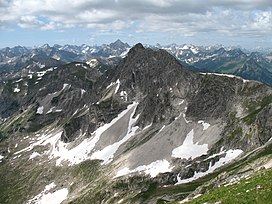
 The Rauhhorn seen from the Gaishorn. | |
| Highest point | |
| Elevation | 2,240 m (7,350 ft) |
| Geography | |
| Location | Bavaria, Germany |
Rauhhorn is a mountain of Bavaria, Germany.
47°28′N 10°28′E / 47.467°N 10.467°E
You can help expand this article with text translated from
the corresponding article in German. (June 2010) Click [show] for important translation instructions.
|
| Rauhhorn | |
|---|---|
 The Rauhhorn seen from the Gaishorn. | |
| Highest point | |
| Elevation | 2,240 m (7,350 ft) |
| Geography | |
| Location | Bavaria, Germany |
Rauhhorn is a mountain of Bavaria, Germany.
47°28′N 10°28′E / 47.467°N 10.467°E