| Rainbow Mountain | |
|---|---|
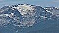
.jpg) Southwest aspect, seen from Tricouni Peak | |
| Highest point | |
| Elevation | 2,314 m (7,592 ft) [1] |
| Prominence | 1,019 m (3,343 ft) [1] |
| Parent peak | Mount Callaghan [1] |
| Coordinates | 50°10′47″N 123°03′13″W / 50.17972°N 123.05361°W [2] |
| Geography | |
 Rainbow Mountain Location in British Columbia  Rainbow Mountain Rainbow Mountain (Canada) | |
| Country | Canada |
| Province | British Columbia |
| District | New Westminster Land District |
| Parent range | Garibaldi Ranges |
| Topo map | NTS 92J3 Brandywine Falls |
| Climbing | |
| Easiest route | Scramble |
Rainbow Mountain is a broad glaciated summit forming the northeastern wall of the Callaghan Valley in the Pacific Ranges of British Columbia, Canada. Located in the middle of the Sea to Sky Country, the mountain is just 9 km (5.6 mi) northwest of the resort town of Whistler, and is a popular destination for hiking, snowshoeing and ski touring.
Climate
Based on the Köppen climate classification, Rainbow Mountain is located in the marine west coast climate zone of western North America. [3] Most weather fronts originate in the Pacific Ocean, and travel east toward the Coast Mountains where they are forced upward by the range ( Orographic lift), causing them to drop their moisture in the form of rain or snowfall. As a result, the Coast Mountains experience high precipitation, especially during the winter months in the form of snowfall. Winter temperatures can drop below −20 °C with wind chill factors below −30 °C.
See also
Gallery
-
 Southeast aspect of Rainbow Mountain centered in the distance. View from ski slopes at Whistler.
 -
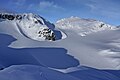
 East aspect
 -


References
- ^ a b c "Rainbow Mountain". Bivouac.com. Retrieved 5 April 2015.
- ^ "Rainbow Mountain". BC Geographical Names. Retrieved 5 April 2015.
- ^ Peel, M. C.; Finlayson, B. L. & McMahon, T. A. (2007). "Updated world map of the Köppen−Geiger climate classification". Hydrol. Earth Syst. Sci. 11. ISSN 1027-5606.
External links
- Weather: Rainbow Mountain
|
| This article about a location in British Columbia, Canada is a stub. You can help Wikipedia by expanding it. |
| Rainbow Mountain | |
|---|---|
|
Southwest aspect, seen from Tricouni Peak | |
| Highest point | |
| Elevation | 2,314 m (7,592 ft) [1] |
| Prominence | 1,019 m (3,343 ft) [1] |
| Parent peak | Mount Callaghan [1] |
| Coordinates | 50°10′47″N 123°03′13″W / 50.17972°N 123.05361°W [2] |
| Geography | |
Rainbow Mountain Location in British Columbia Rainbow Mountain Rainbow Mountain (Canada) | |
| Country | Canada |
| Province | British Columbia |
| District | New Westminster Land District |
| Parent range | Garibaldi Ranges |
| Topo map | NTS 92J3 Brandywine Falls |
| Climbing | |
| Easiest route | Scramble |
Rainbow Mountain is a broad glaciated summit forming the northeastern wall of the Callaghan Valley in the Pacific Ranges of British Columbia, Canada. Located in the middle of the Sea to Sky Country, the mountain is just 9 km (5.6 mi) northwest of the resort town of Whistler, and is a popular destination for hiking, snowshoeing and ski touring.
Climate
Based on the Köppen climate classification, Rainbow Mountain is located in the marine west coast climate zone of western North America. [3] Most weather fronts originate in the Pacific Ocean, and travel east toward the Coast Mountains where they are forced upward by the range ( Orographic lift), causing them to drop their moisture in the form of rain or snowfall. As a result, the Coast Mountains experience high precipitation, especially during the winter months in the form of snowfall. Winter temperatures can drop below −20 °C with wind chill factors below −30 °C.
See also
Gallery
-
Southeast aspect of Rainbow Mountain centered in the distance. View from ski slopes at Whistler.
-
East aspect
-
References
- ^ a b c "Rainbow Mountain". Bivouac.com. Retrieved 5 April 2015.
- ^ "Rainbow Mountain". BC Geographical Names. Retrieved 5 April 2015.
- ^ Peel, M. C.; Finlayson, B. L. & McMahon, T. A. (2007). "Updated world map of the Köppen−Geiger climate classification". Hydrol. Earth Syst. Sci. 11. ISSN 1027-5606.
External links
- Weather: Rainbow Mountain
|
| This article about a location in British Columbia, Canada is a stub. You can help Wikipedia by expanding it. |