Rabbi
Radi (Radden) | |
|---|---|
| Comune di Rabbi | |
 A waterfall during summer in Rabbi | |
 Rabbi Location of Rabbi in Italy  Rabbi Rabbi (Trentino-Alto Adige/Südtirol) | |
| Coordinates: 46°24′N 10°51′E / 46.400°N 10.850°E | |
| Country | Italy |
| Region | Trentino-Alto Adige/Südtirol |
| Province | Trentino (TN) |
| Frazioni | Piazzola, Pracorno, San Bernardo (Municipal Building) |
| Government | |
| • Mayor | Lorenzo Cicolini |
| Area | |
| • Total | 132.4 km2 (51.1 sq mi) |
| Population (Dec. 2004)
[2] | |
| • Total | 1,447 |
| • Density | 11/km2 (28/sq mi) |
| Demonym(s) | called "corvi" in San Bernardo, "chjaore" in Piazzola, and "gósi" in Pracorno |
| Time zone | UTC+1 ( CET) |
| • Summer ( DST) | UTC+2 ( CEST) |
| Postal code | 38020 |
| Dialing code | 0463 |
| Patron saint | Our Lady of Caravaggio (Pracorno), San Bernardo (St. Bernard), St. John of Nepomuk |

Rabbi (Rabi in local dialect) is a comune (municipality) in Trentino in the northern Italian region Trentino-Alto Adige/Südtirol, located about 40 kilometres (25 mi) northwest of Trento. As of 31 December 2004, it had a population of 1,447 and an area of 132.4 square kilometres (51.1 sq mi). [3]
Rabbi borders the following municipalities: Ulten, Martell, Bresimo, Peio, Malè, Mezzana, Commezzadura and Pellizzano.
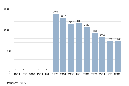
Demographic evolution
References
- ^ "Superficie di Comuni Province e Regioni italiane al 9 ottobre 2011". Italian National Institute of Statistics. Retrieved 16 March 2019.
- ^ "Popolazione Residente al 1° Gennaio 2018". Italian National Institute of Statistics. Retrieved 16 March 2019.
- ^ All demographics and other statistics: Italian statistical institute Istat.

| International | |
|---|---|
| National | |
| Geographic | |
|
| This Trentino-Alto Adige/Südtirol location article is a stub. You can help Wikipedia by expanding it. |
Rabbi
Radi (Radden) | |
|---|---|
| Comune di Rabbi | |
|
A waterfall during summer in Rabbi | |
Rabbi Location of Rabbi in Italy Rabbi Rabbi (Trentino-Alto Adige/Südtirol) | |
| Coordinates: 46°24′N 10°51′E / 46.400°N 10.850°E | |
| Country | Italy |
| Region | Trentino-Alto Adige/Südtirol |
| Province | Trentino (TN) |
| Frazioni | Piazzola, Pracorno, San Bernardo (Municipal Building) |
| Government | |
| • Mayor | Lorenzo Cicolini |
| Area | |
| • Total | 132.4 km2 (51.1 sq mi) |
| Population (Dec. 2004)
[2] | |
| • Total | 1,447 |
| • Density | 11/km2 (28/sq mi) |
| Demonym(s) | called "corvi" in San Bernardo, "chjaore" in Piazzola, and "gósi" in Pracorno |
| Time zone | UTC+1 ( CET) |
| • Summer ( DST) | UTC+2 ( CEST) |
| Postal code | 38020 |
| Dialing code | 0463 |
| Patron saint | Our Lady of Caravaggio (Pracorno), San Bernardo (St. Bernard), St. John of Nepomuk |
Rabbi (Rabi in local dialect) is a comune (municipality) in Trentino in the northern Italian region Trentino-Alto Adige/Südtirol, located about 40 kilometres (25 mi) northwest of Trento. As of 31 December 2004, it had a population of 1,447 and an area of 132.4 square kilometres (51.1 sq mi). [3]
Rabbi borders the following municipalities: Ulten, Martell, Bresimo, Peio, Malè, Mezzana, Commezzadura and Pellizzano.
Demographic evolution
References
- ^ "Superficie di Comuni Province e Regioni italiane al 9 ottobre 2011". Italian National Institute of Statistics. Retrieved 16 March 2019.
- ^ "Popolazione Residente al 1° Gennaio 2018". Italian National Institute of Statistics. Retrieved 16 March 2019.
- ^ All demographics and other statistics: Italian statistical institute Istat.
| International | |
|---|---|
| National | |
| Geographic | |
|
| This Trentino-Alto Adige/Südtirol location article is a stub. You can help Wikipedia by expanding it. |