Raamsdonk | |
|---|---|
Village | |
 Catholic church
Saint-Bavo | |
 Raamsdonk Location in the province of North Brabant in the Netherlands  Raamsdonk Raamsdonk (Netherlands) | |
| Coordinates: 51°41′16″N 4°54′29″E / 51.68778°N 4.90806°E | |
| Country | Netherlands |
| Province | North Brabant |
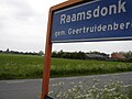
| Municipality | Geertruidenberg |
| Area | |
| • Total | 13.70 km2 (5.29 sq mi) |
| Elevation | 2.4 m (7.9 ft) |
| Population (2021)
[1] | |
| • Total | 2,255 |
| • Density | 160/km2 (430/sq mi) |
| Time zone | UTC+1 ( CET) |
| • Summer ( DST) | UTC+2 ( CEST) |
| Postal code | 4944
[1] |
| Dialing code | 0162 |
Raamsdonk is a village in the province of North Brabant, Netherlands. It is located in the municipality of Geertruidenberg, about 15 km northeast of Breda.
Toponymy
Raamsdonk (as "Dunc") is mentioned for the first time in 1253 as Ramesdunc and 1330 as Raemsdonc. A "dunc" or "dark" is a sand hill in a marshy area. The " Raams " prefix may indicate the presence of a certain type of plant, the wild garlic. However, it may also be the name of a person.
History
In 1609, the St. Lambert church became part of the Reformed Church. In 1611, the first pastor came.
The Catholic people were allowed, in 1690, to establish a church in a barn. In the hamlet Waspikse the Benedenkerk. In 1787, another church in a barn was installed in Raamsdonk. This church was dedicated to Saint-Bavo and was in Bergenstraat. In 1798, however, Catholics demanded to return to the St. Lambert church. They did not succeed but received a sum of money in compensation. The barn church served the community until 1888. Then a new monumental St. Bavo Church, was built according to the plans of the architect Carl Weber. It is located in the present village.
At Raamsdonk until about 1850 existed a small French community. [3]
Raamsdonk was a separate municipality until 1997, when it became part of Geertruidenberg. [4]
Gallery
-
 Entrance Wielstraat, view Raamsdonk-Dorp and Church of Saint-Bavo
 -
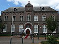 Ontmoetingscentrum


References
- ^ a b c "Kerncijfers wijken en buurten 2021". Central Bureau of Statistics. Retrieved 16 April 2022.
- ^ "Postcodetool for 4944AA". Actueel Hoogtebestand Nederland (in Dutch). Het Waterschapshuis. Retrieved 16 April 2022.
- ^ Regionaal Archief Tilburg
- ^ Ad van der Meer and Onno Boonstra, Repertorium van Nederlandse gemeenten, KNAW, 2011.
| Authority control databases: National |
|---|
Raamsdonk | |
|---|---|
Village | |
|
Catholic church
Saint-Bavo | |
Raamsdonk Location in the province of North Brabant in the Netherlands Raamsdonk Raamsdonk (Netherlands) | |
| Coordinates: 51°41′16″N 4°54′29″E / 51.68778°N 4.90806°E | |
| Country | Netherlands |
| Province | North Brabant |
| Municipality | Geertruidenberg |
| Area | |
| • Total | 13.70 km2 (5.29 sq mi) |
| Elevation | 2.4 m (7.9 ft) |
| Population (2021)
[1] | |
| • Total | 2,255 |
| • Density | 160/km2 (430/sq mi) |
| Time zone | UTC+1 ( CET) |
| • Summer ( DST) | UTC+2 ( CEST) |
| Postal code | 4944
[1] |
| Dialing code | 0162 |
Raamsdonk is a village in the province of North Brabant, Netherlands. It is located in the municipality of Geertruidenberg, about 15 km northeast of Breda.
Toponymy
Raamsdonk (as "Dunc") is mentioned for the first time in 1253 as Ramesdunc and 1330 as Raemsdonc. A "dunc" or "dark" is a sand hill in a marshy area. The " Raams " prefix may indicate the presence of a certain type of plant, the wild garlic. However, it may also be the name of a person.
History
In 1609, the St. Lambert church became part of the Reformed Church. In 1611, the first pastor came.
The Catholic people were allowed, in 1690, to establish a church in a barn. In the hamlet Waspikse the Benedenkerk. In 1787, another church in a barn was installed in Raamsdonk. This church was dedicated to Saint-Bavo and was in Bergenstraat. In 1798, however, Catholics demanded to return to the St. Lambert church. They did not succeed but received a sum of money in compensation. The barn church served the community until 1888. Then a new monumental St. Bavo Church, was built according to the plans of the architect Carl Weber. It is located in the present village.
At Raamsdonk until about 1850 existed a small French community. [3]
Raamsdonk was a separate municipality until 1997, when it became part of Geertruidenberg. [4]
Gallery
-
Entrance Wielstraat, view Raamsdonk-Dorp and Church of Saint-Bavo
-
Ontmoetingscentrum
References
- ^ a b c "Kerncijfers wijken en buurten 2021". Central Bureau of Statistics. Retrieved 16 April 2022.
- ^ "Postcodetool for 4944AA". Actueel Hoogtebestand Nederland (in Dutch). Het Waterschapshuis. Retrieved 16 April 2022.
- ^ Regionaal Archief Tilburg
- ^ Ad van der Meer and Onno Boonstra, Repertorium van Nederlandse gemeenten, KNAW, 2011.
| Authority control databases: National |
|---|