Puchheim | |
|---|---|
 Saint Joseph Church | |
 Coat of arms | |
Location of Puchheim within Fürstenfeldbruck district 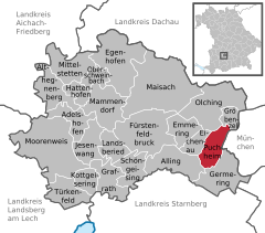 | |
 Puchheim  Puchheim | |
| Coordinates: 48°09′N 11°21′E / 48.150°N 11.350°E | |
| Country | Germany |
| State | Bavaria |
| Admin. region | Oberbayern |
| District | Fürstenfeldbruck |
| Subdivisions | 2 Ortsteile |
| Government | |
| • Mayor (2020–26) | Norbert Seidl [1] ( SPD) |
| Area | |
| • Total | 12.23 km2 (4.72 sq mi) |
| Elevation | 535 m (1,755 ft) |
| Population (2022-12-31)
[2] | |
| • Total | 21,420 |
| • Density | 1,800/km2 (4,500/sq mi) |
| Time zone | UTC+01:00 ( CET) |
| • Summer ( DST) | UTC+02:00 ( CEST) |
| Postal codes | 82178 |
| Dialling codes | 089 |
| Vehicle registration | FFB |
| Website | www.puchheim.de |
Puchheim ( Central Bavarian: Buachham) is suburb to Munich in the district of Fürstenfeldbruck, in Bavaria, Germany. It has about 20,000 inhabitants.
Puchheim is divided into two parts: the old and rural part called Puchheim-Ort and the new part of Puchheim (Puchheim-Bahnhof) that was founded when the Munich S-Bahn was built. Before that there was one of the first civil airfields in Bavaria, which was later used as a prisoner of war camp during World War I. [3] The area around the camp was dried up by workers from the POW camp, so that houses could be built.
The old part of Puchheim is even older than Munich.[ citation needed]
Transport
Puchheim is well connected to the regional and national traffic network by
S-Bahn
![]() (
S4) and
Autobahn (
A 8,
A 99).
(
S4) and
Autobahn (
A 8,
A 99).
Twin towns – sister cities
-
 Attnang-Puchheim, Austria
 -
 Nagykanizsa, Hungary
 -
 Salo, Finland
 -
Zalakaros, Hungary
References
- ^ Liste der ersten Bürgermeister/Oberbürgermeister in kreisangehörigen Gemeinden, Bayerisches Landesamt für Statistik, 15 July 2021.
- ^ Genesis Online-Datenbank des Bayerischen Landesamtes für Statistik Tabelle 12411-003r Fortschreibung des Bevölkerungsstandes: Gemeinden, Stichtag (Einwohnerzahlen auf Grundlage des Zensus 2011) ( Hilfe dazu).
- ^ "Aus der Geschichte Puchheims". Stadt Puchheim (City of Puchheim). Archived from the original on 19 July 2011. Retrieved 1 March 2014.
- ^ "Partnerstädte". puchheim.de (in German). Puchheim. Retrieved 2021-03-11.
Towns and municipalities in
Fürstenfeldbruck district | ||
|---|---|---|
| International | |
|---|---|
| National | |
| Geographic | |
|
| This Fürstenfeldbruck district location article is a stub. You can help Wikipedia by expanding it. |
Puchheim | |
|---|---|
|
Saint Joseph Church | |
|
Coat of arms | |
Location of Puchheim within Fürstenfeldbruck district | |
Puchheim Puchheim | |
| Coordinates: 48°09′N 11°21′E / 48.150°N 11.350°E | |
| Country | Germany |
| State | Bavaria |
| Admin. region | Oberbayern |
| District | Fürstenfeldbruck |
| Subdivisions | 2 Ortsteile |
| Government | |
| • Mayor (2020–26) | Norbert Seidl [1] ( SPD) |
| Area | |
| • Total | 12.23 km2 (4.72 sq mi) |
| Elevation | 535 m (1,755 ft) |
| Population (2022-12-31)
[2] | |
| • Total | 21,420 |
| • Density | 1,800/km2 (4,500/sq mi) |
| Time zone | UTC+01:00 ( CET) |
| • Summer ( DST) | UTC+02:00 ( CEST) |
| Postal codes | 82178 |
| Dialling codes | 089 |
| Vehicle registration | FFB |
| Website | www.puchheim.de |
Puchheim ( Central Bavarian: Buachham) is suburb to Munich in the district of Fürstenfeldbruck, in Bavaria, Germany. It has about 20,000 inhabitants.
Puchheim is divided into two parts: the old and rural part called Puchheim-Ort and the new part of Puchheim (Puchheim-Bahnhof) that was founded when the Munich S-Bahn was built. Before that there was one of the first civil airfields in Bavaria, which was later used as a prisoner of war camp during World War I. [3] The area around the camp was dried up by workers from the POW camp, so that houses could be built.
The old part of Puchheim is even older than Munich.[ citation needed]
Transport
Puchheim is well connected to the regional and national traffic network by
S-Bahn
![]() (
S4) and
Autobahn (
A 8,
A 99).
(
S4) and
Autobahn (
A 8,
A 99).
Twin towns – sister cities
-
Attnang-Puchheim, Austria
-
Nagykanizsa, Hungary
-
Salo, Finland
-
Zalakaros, Hungary
References
- ^ Liste der ersten Bürgermeister/Oberbürgermeister in kreisangehörigen Gemeinden, Bayerisches Landesamt für Statistik, 15 July 2021.
- ^ Genesis Online-Datenbank des Bayerischen Landesamtes für Statistik Tabelle 12411-003r Fortschreibung des Bevölkerungsstandes: Gemeinden, Stichtag (Einwohnerzahlen auf Grundlage des Zensus 2011) ( Hilfe dazu).
- ^ "Aus der Geschichte Puchheims". Stadt Puchheim (City of Puchheim). Archived from the original on 19 July 2011. Retrieved 1 March 2014.
- ^ "Partnerstädte". puchheim.de (in German). Puchheim. Retrieved 2021-03-11.
Towns and municipalities in
Fürstenfeldbruck district | ||
|---|---|---|
| International | |
|---|---|
| National | |
| Geographic | |
|
| This Fürstenfeldbruck district location article is a stub. You can help Wikipedia by expanding it. |