Prad am Stilfser Joch | |
|---|---|
| Marktgemeinde Prad aSJ Comune di Prato aS | |
 The village viewed from north | |
 Coat of arms | |
 Prad am Stilfser Joch Location of Prad am Stilfser Joch in Italy  Prad am Stilfser Joch Prad am Stilfser Joch (Trentino-Alto Adige/Südtirol) | |
| Coordinates: 46°37′N 10°36′E / 46.617°N 10.600°E | |
| Country | Italy |
| Region | Trentino-Alto Adige/Südtirol |
| Province | South Tyrol (BZ) |
| Frazioni | Lichtenberg (Montechiaro) |
| Government | |
| • Mayor | Rafael Alber |
| Area | |
| • Total | 51.4 km2 (19.8 sq mi) |
| Elevation | 915 m (3,002 ft) |
| Population (Dec. 2015)
[2] | |
| • Total | 3.474 |
| • Density | 0.068/km2 (0.18/sq mi) |
| Demonym(s) | German: Prader Italian: pratesi |
| Time zone | UTC+1 ( CET) |
| • Summer ( DST) | UTC+2 ( CEST) |
| Postal code | 39026 |
| Dialing code | 0473 |
| Website | Official website |
Prad am Stilfser Joch (German pronunciation: [praˑt am ˈʃtɪlfsɐ jɔx]; Italian: Prato allo Stelvio [ˈpraːto ˈallo ˈstɛlvjo]), often abbreviated to Prad, is a comune (municipality) and a village in South Tyrol in northern Italy, located about 60 kilometres (37 mi) west of the city of Bolzano, on the border with Switzerland, and near the Stelvio Pass.
Geography
As of 31 December 2015, it had a population of 3,474 and an area of 51.4 square kilometres (19.8 sq mi). [3]
The municipality contains the frazione (subdivision) Lichtenberg (Montechiaro).
Prad borders the following municipalities: Glurns, Laas, Schluderns, Stilfs, Taufers im Münstertal and Müstair (Switzerland).
History
Coat-of-arms
The emblem shows three or ears of wheat, in a gules field on azure. The bottom is red. The wheat symbolizes the importance played by the cereal growing in the municipality. The emblem was adopted in 1969. [4]
Society
Linguistic distribution
According to the 2011 census, 97.21% of the population speak German, 2.73% Italian and 0.06% Ladin as first language. [5]
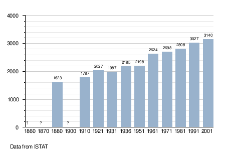
Demographic evolution
Sport
Notable people
- Gustav Thöni, alpine ski racer
References
- ^ "Superficie di Comuni Province e Regioni italiane al 9 ottobre 2011". Italian National Institute of Statistics. Retrieved 16 March 2019.
- ^ "Popolazione Residente al 1° Gennaio 2018". Italian National Institute of Statistics. Retrieved 16 March 2019.
- ^ All demographics and other statistics: Italian statistical institute Istat.
- ^ Heraldry of the World: Prad am Stilfser Joch
- ^ "Volkszählung 2011/Censimento della popolazione 2011". astat info (38). Provincial Statistics Institute of the Autonomous Province of South Tyrol: 6–7. June 2012. Retrieved 2012-06-14.
External links
![]() Media related to
Prad am Stilfser Joch at Wikimedia Commons
Media related to
Prad am Stilfser Joch at Wikimedia Commons
- (in German and Italian) Homepage of the municipality

| International | |
|---|---|
| National | |
Prad am Stilfser Joch | |
|---|---|
| Marktgemeinde Prad aSJ Comune di Prato aS | |
|
The village viewed from north | |
|
Coat of arms | |
Prad am Stilfser Joch Location of Prad am Stilfser Joch in Italy Prad am Stilfser Joch Prad am Stilfser Joch (Trentino-Alto Adige/Südtirol) | |
| Coordinates: 46°37′N 10°36′E / 46.617°N 10.600°E | |
| Country | Italy |
| Region | Trentino-Alto Adige/Südtirol |
| Province | South Tyrol (BZ) |
| Frazioni | Lichtenberg (Montechiaro) |
| Government | |
| • Mayor | Rafael Alber |
| Area | |
| • Total | 51.4 km2 (19.8 sq mi) |
| Elevation | 915 m (3,002 ft) |
| Population (Dec. 2015)
[2] | |
| • Total | 3.474 |
| • Density | 0.068/km2 (0.18/sq mi) |
| Demonym(s) | German: Prader Italian: pratesi |
| Time zone | UTC+1 ( CET) |
| • Summer ( DST) | UTC+2 ( CEST) |
| Postal code | 39026 |
| Dialing code | 0473 |
| Website | Official website |
Prad am Stilfser Joch (German pronunciation: [praˑt am ˈʃtɪlfsɐ jɔx]; Italian: Prato allo Stelvio [ˈpraːto ˈallo ˈstɛlvjo]), often abbreviated to Prad, is a comune (municipality) and a village in South Tyrol in northern Italy, located about 60 kilometres (37 mi) west of the city of Bolzano, on the border with Switzerland, and near the Stelvio Pass.
Geography
As of 31 December 2015, it had a population of 3,474 and an area of 51.4 square kilometres (19.8 sq mi). [3]
The municipality contains the frazione (subdivision) Lichtenberg (Montechiaro).
Prad borders the following municipalities: Glurns, Laas, Schluderns, Stilfs, Taufers im Münstertal and Müstair (Switzerland).
History
Coat-of-arms
The emblem shows three or ears of wheat, in a gules field on azure. The bottom is red. The wheat symbolizes the importance played by the cereal growing in the municipality. The emblem was adopted in 1969. [4]
Society
Linguistic distribution
According to the 2011 census, 97.21% of the population speak German, 2.73% Italian and 0.06% Ladin as first language. [5]
Demographic evolution
Sport
Notable people
- Gustav Thöni, alpine ski racer
References
- ^ "Superficie di Comuni Province e Regioni italiane al 9 ottobre 2011". Italian National Institute of Statistics. Retrieved 16 March 2019.
- ^ "Popolazione Residente al 1° Gennaio 2018". Italian National Institute of Statistics. Retrieved 16 March 2019.
- ^ All demographics and other statistics: Italian statistical institute Istat.
- ^ Heraldry of the World: Prad am Stilfser Joch
- ^ "Volkszählung 2011/Censimento della popolazione 2011". astat info (38). Provincial Statistics Institute of the Autonomous Province of South Tyrol: 6–7. June 2012. Retrieved 2012-06-14.
External links
![]() Media related to
Prad am Stilfser Joch at Wikimedia Commons
Media related to
Prad am Stilfser Joch at Wikimedia Commons
- (in German and Italian) Homepage of the municipality
| International | |
|---|---|
| National | |