Portet-sur-Garonne | |
|---|---|
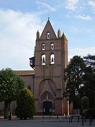
 The church in Portet-sur-Garonne | |
| Coordinates: 43°31′23″N 1°24′24″E / 43.5231°N 1.4067°E | |
| Country | France |
| Region | Occitania |
| Department | Haute-Garonne |
| Arrondissement | Muret |
| Canton | Portet-sur-Garonne |
| Intercommunality | Le Muretain Agglo |
| Government | |
| • Mayor (2020–2026) | Thierry Suaud [1] |
| Area 1 | 16.19 km2 (6.25 sq mi) |
| Population (2021)
[2] | 9,805 |
| • Density | 610/km2 (1,600/sq mi) |
| Time zone | UTC+01:00 ( CET) |
| • Summer ( DST) | UTC+02:00 ( CEST) |
| INSEE/Postal code |
31433 /31120 |
| Elevation | 142–235 m (466–771 ft) (avg. 150 m or 490 ft) |
| 1 French Land Register data, which excludes lakes, ponds, glaciers > 1 km2 (0.386 sq mi or 247 acres) and river estuaries. | |
Portet-sur-Garonne (French pronunciation: [pɔʁtɛ syʁ ɡaʁɔn], literally Portet on Garonne; Languedocien: Portèth de Garona) is a commune in the Haute-Garonne department in southwestern France. Portet-Saint-Simon station has rail connections to Foix, Tarbes, and Toulouse, which is the nearest big city, about 10 km away.
The inhabitants of the commune are known as Portésiens in French.
|
| |||||||||||||||||||||||||||||||||||||||||||||||||||||||||||||||||||||||||||||||||||||||||||||||||||||||||||||||||||||
| Source: EHESS [3] and INSEE (1968-2017) [4] | ||||||||||||||||||||||||||||||||||||||||||||||||||||||||||||||||||||||||||||||||||||||||||||||||||||||||||||||||||||||
- ^ "Répertoire national des élus: les maires". data.gouv.fr, Plateforme ouverte des données publiques françaises (in French). 2 December 2020.
- ^ "Populations légales 2021" (in French). The National Institute of Statistics and Economic Studies. 28 December 2023.
- ^ Des villages de Cassini aux communes d'aujourd'hui: Commune data sheet Portet-sur-Garonne, EHESS (in French).
- ^ Population en historique depuis 1968, INSEE
Portet-sur-Garonne | |
|---|---|
 The church in Portet-sur-Garonne | |
| Coordinates: 43°31′23″N 1°24′24″E / 43.5231°N 1.4067°E | |
| Country | France |
| Region | Occitania |
| Department | Haute-Garonne |
| Arrondissement | Muret |
| Canton | Portet-sur-Garonne |
| Intercommunality | Le Muretain Agglo |
| Government | |
| • Mayor (2020–2026) | Thierry Suaud [1] |
| Area 1 | 16.19 km2 (6.25 sq mi) |
| Population (2021)
[2] | 9,805 |
| • Density | 610/km2 (1,600/sq mi) |
| Time zone | UTC+01:00 ( CET) |
| • Summer ( DST) | UTC+02:00 ( CEST) |
| INSEE/Postal code |
31433 /31120 |
| Elevation | 142–235 m (466–771 ft) (avg. 150 m or 490 ft) |
| 1 French Land Register data, which excludes lakes, ponds, glaciers > 1 km2 (0.386 sq mi or 247 acres) and river estuaries. | |
Portet-sur-Garonne (French pronunciation: [pɔʁtɛ syʁ ɡaʁɔn], literally Portet on Garonne; Languedocien: Portèth de Garona) is a commune in the Haute-Garonne department in southwestern France. Portet-Saint-Simon station has rail connections to Foix, Tarbes, and Toulouse, which is the nearest big city, about 10 km away.
The inhabitants of the commune are known as Portésiens in French.
|
| |||||||||||||||||||||||||||||||||||||||||||||||||||||||||||||||||||||||||||||||||||||||||||||||||||||||||||||||||||||
| Source: EHESS [3] and INSEE (1968-2017) [4] | ||||||||||||||||||||||||||||||||||||||||||||||||||||||||||||||||||||||||||||||||||||||||||||||||||||||||||||||||||||||
- ^ "Répertoire national des élus: les maires". data.gouv.fr, Plateforme ouverte des données publiques françaises (in French). 2 December 2020.
- ^ "Populations légales 2021" (in French). The National Institute of Statistics and Economic Studies. 28 December 2023.
- ^ Des villages de Cassini aux communes d'aujourd'hui: Commune data sheet Portet-sur-Garonne, EHESS (in French).
- ^ Population en historique depuis 1968, INSEE


