You can help expand this article with text translated from
the corresponding article in Spanish. (December 2009) Click [show] for important translation instructions.
View a machine-translated version of the Spanish article.
Machine translation, like
DeepL or
Google Translate, is a useful starting point for translations, but translators must revise errors as necessary and confirm that the translation is accurate, rather than simply copy-pasting machine-translated text into the English Wikipedia.
Do not translate text that appears unreliable or low-quality. If possible, verify the text with references provided in the foreign-language article.
You must provide
copyright attribution in the
edit summary accompanying your translation by providing an
interlanguage link to the source of your translation. A model attribution edit summary is Content in this edit is translated from the existing Spanish Wikipedia article at [[:es:Port Vila]]; see its history for attribution.
You may also add the template {{Translated|es|Port Vila}} to the
talk page.
The population was 49,034 as of the
2020 census.[2] In 2020, the population of Port Vila formed 16.3% of the country's population.
On the south coast of the island of Efate, in
Shefa Province, Port Vila is the economic and commercial centre of Vanuatu. The mayor is Erick Puyo Festa, of the
Vanua'aku Pati, elected in January 2018; his deputy is Jenny Regenvanu, of the
Graun mo Jastis Pati.[3]
On 13 March 2015, Port Vila suffered extensive damage from
Cyclone Pam.[4]
Name
Locally the town is most commonly referred to simply as "Vila", whether in French or Bislama [viˈla] or in English /ˈviːlə/VEE-lə (not like English "villa").[citation needed]
The name of the area is Efil in the native
South Efate language and Ifira in neighbouring
Mele-Fila language. Vila is a variant of these names.
Ifira is a small island in Vila harbour where many of the area's traditional landowners reside.
History
The area occupied by Port Vila has been inhabited by
Melanesian people for thousands of years. In Autumn of 2004, an archaeological expedition known as Teouma discovered a burial site of 25 tombs containing three dozen skeletons of members of the
Lapita culture. Pieces of ceramics found at the site were dated to the 13th century BC.
Efate Island was charted in 1774 by
James Cook, who named it Sandwich Island. Cook's expedition did not land but noted the presence of good harbours and land suitable for European settlement. In late 19th century when the islands were known as the
New Hebrides, the British were initially the dominant European presence, though by the 1890s, the economic balance had begun to favour the French, who established large plantations. French citizen Ferdinand Chevillard began buying and clearing land around Port Vila to be converted into the largest French plantation on the island. Instead, it was converted into the municipality of
Franceville, which declared independence on 9 August 1889, though this only lasted until June of the following year.
It was the first
self-governing nation to practice
universal suffrage without distinction of sex or race. Although the population at the time consisted of about 500 native islanders and fewer than fifty whites, only the latter were permitted to hold office. One of the elected presidents was a US citizen by birth, R. D. Polk, a relative of American president
James K. Polk.[5]
After 1887, the territory was jointly administered by the
French and the
British. This was formalized in 1906 as an Anglo-French
Condominium. During
World War II, Port Vila was an American and Australian airbase.
In 1987,
Cyclone Uma severely damaged the city. A powerful earthquake in January 2002 caused minor damage in the capital and surrounding areas. The city suffered massive damage from a category 5 cyclone named
Cyclone Pam in March 2015, whose
eye wall passed just to the east of Port Vila.
Geography
Climate
Port Vila has a
tropical climate, more specifically a
tropical rainforest climate, with noticeably wetter and drier months. As the trade winds are almost permanent and cyclones are not rare in Port Vila, the climate is not equatorial but maritime trade-wind tropical climate.[6] Rainfall averages about 2,338.9 millimetres or 92.08 inches per year, and the wettest month is March. The driest month is September. There are 153 wet days in an average year. The area also has south-east
trade winds. Temperatures do not vary very much at all throughout the year, and the record high is 35.6 °C or 96.1 °F. The coolest month, July, has an average high of 27 °C or 80.6 °F, and an average low of 18 °C or 64.4 °F. The hottest month, February, has an average high of 31.2 °C or 88.2 °F and an average low of 23 °C or 73.4 °F. The record low for Port Vila is 8.5 °C or 47.3 °F.
Humidity is often high.
Port Vila is Vanuatu's most important
harbour and the center of the country's trade. The international airport,
Bauerfield International (VLI) is also located in the city.
Air Vanuatu has its head office in Vanuatu House in Port Vila.[9]
Major industries in the city remain agriculture and fishing. Tourism is also becoming important, especially from
Australia and
New Zealand. There were over 80,000 visitors in 1997.[10]
Vanuatu is a
tax haven, and offshore financing in Port Vila is an important part of the economy.
Vanuatu is still dependent on
foreign aid, most of which comes from Australia and New Zealand, although in recent years aid has also come from
China. One example was New Zealand paying to train doctors selected from the local community, then paying part of their wages during the first year after qualification. Australia has paid consultants to work in
Port Vila Central Hospital.
35.7% of exports leave from Port Vila and 86.9% of imports arrive in Port Vila. [citation needed]
The population is around 45,000; predominately
Melanesian, with small
Polynesian, Asian, Australian and European populations, mainly French and British.
The day-to-day
lingua franca in the capital city is
Bislama. In addition, English and French are also widespread.
Among Vanuatu's 100
indigenous languages, many are spoken in the capital, as people from rural areas come to live in the city, either temporarily or permanently.
Religion
Christianity is the predominant religion across Vanuatu, followed by more than 90% of the population. The largest denomination is the
Presbyterian Church in Vanuatu, followed by one third of the population. Roman Catholicism and the
Church of Melanesia are also common, each about 15%.
Cathédrale du Sacré-Cœur is a modern Roman Catholic cathedral in Port Vila. The seat of the Diocese of Port Vila,[11] the church is dedicated to the
Sacred Heart of Jesus.[12] On October 5, 2020,
The Church of Jesus Christ of Latter-Day Saints announced plans to construct a temple in the city, and the
Bahá'í community is also established in Port Vila.[13]
Culture and education
Highlights of the city
The capital of Vanuatu has various sights to offer. There are several memorials, e.g. opposite the Parliament where two traditional totem poles and a monument representing a pig's tusk can be seen. The Presbyterian Church of Port Vila is an impressive and sightworthy building opposite the
Independence Park. A colourful wall painting can be seen on the administration building opposite the market hall. Another noteworthy wall painting is on the façade of the post office. The City Hall of Port Vila is an oblong and sightworthy building on a hill in the city centre.
Cityscape
Presbyterian Church
Wall painting opposite the market
Vanuatu Parliament
Memorial opposite the Parliament building
Market hall
Market
Post office. The building once marked the unofficial demarcation between the two sectors of Port Vila, the British Paddock to the south and the Quartier français to the north
The natural harbour as viewed from town looking out at sea with Iririki Island to the left
City Hall
Grand Hotel and Casino Vanuatu, the tallest building in the country
The Vanuatu Cultural Centre, hosting the
Vanuatu National Museum, is located at the Saralana Park in front of the national parliament, close to the National Library and the
Malvatumauri (Vanuatu National Council of Chiefs). This institution is an important place for the preservation and promotion of the different aspects of the local culture. Traditional artifacts from several islands are on display in the museum. The centre host also the National Audiovisual Archives which is the most important fund of documents from the late 19th century until today.
World Heritage
Port Vila was the location in August 1999 for the "2nd World Heritage Global Strategy Meeting for the Pacific Islands Region" held by
UNESCO. One of the major topics related to Vanuatu and the Pacific region was the question of the suitability of
underwater heritage for inscription on the
World Heritage List.[14]
Education
This section needs expansion. You can help by
adding to it. (May 2015)
Port Vila is one location of the
University of the South Pacific, an educational institution co-owned by twelve Pacific countries. The Vanuatu campus is the only law school in the university, and it also teaches languages.
Upper secondary (sixth form/senior high school) institutions include:
Malapoa College (Formerly known as British Secondary School)
Onesua Presbyterian College
NTCU Port Vila Christian College
Junior secondary (seventh form to tenth form) institutions include:
Port Vila International School
Central Secondary School
Malapoa College (Formerly known as British Secondary School)
NTCU Port Vila Christian College
Seaside Community Secondary School
Sorovanga Self-Support Community School
Suango Mele Junior Secondary School
Ulei Junior Secondary School
Vila North Secondary School
Institutions
Municipality
The municipality of Port Vila is divided into four wards and administered by a council consisting of 14 members. The four wards are:
Malapoa-Tagabe: Western and far northern neighborhoods
Anabrou-Melcofe-Tassiriki: Northern and eastern neighborhoods
Centre: Nambawan and Seaside neighborhoods
South: Nambatu, Nambatri, and Elluk neighborhoods
Malapoa-Tagabe and South are allotted three representatives each to the council while Anabrou-Melcofe-Tassiriki and Centre have four.[15]
The municipality handles primary education, primary health care, regional planning, road maintenance and construction, trash collection, cemeteries, parks and open spaces and the promotion of tourism.
There are also
informal settlements such as Blacksands which are effectively suburbs of Vila but are outside the municipality. Living conditions in some of these neighbourhoods are very poor, and lack of service provision and insecure land tenure are major problems.[16] Blacksands was
squatted in the 1960s.[17]
The most recent municipal council election was held in
2022.
Constituency
This section needs to be updated. Please help update this article to reflect recent events or newly available information.(May 2015)
^"Wee, Small Republics: A Few Examples of Popular Government," Hawaiian Gazette, 1 Nov 1895, p. 1
^"Climatologie" by Pierre Estienne and Alain Godard, Éditions Armand Colin (
ISBN2-200-31042-0), "CHAPITRE XVI 1. Les climats équatoriaux et subéquatoriaux 2. Les climats tropicaux 3. Les climats d'alizé 4. Les climats de montagne LES CLIMATS DE LA ZONE INTERTROPICALE : LES VARIÉTÉS", pages 314, 315 and 322.
 Presbyterian Church
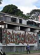 Wall painting opposite the market
 Vanuatu Parliament
 Memorial opposite the Parliament building
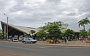 Market hall
 Market
 Post office. The building once marked the unofficial demarcation between the two sectors of Port Vila, the British Paddock to the south and the Quartier français to the north
 The natural harbour as viewed from town looking out at sea with Iririki Island to the left
 City Hall
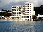 Grand Hotel and Casino Vanuatu, the tallest building in the country
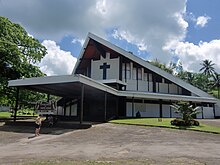


 Media related to
Port Vila at Wikimedia Commons
Media related to
Port Vila at Wikimedia Commons