PhotosLocation


polle Latitude and Longitude:

51°54′N 9°24′E / 51.900°N 9.400°E / 51.900; 9.400
From Wikipedia, the free encyclopedia
Polle
Polle
Polle
Coat of arms of Polle
Location of Polle within Holzminden district
Holzminden (district) Lower Saxony Hesse North Rhine-Westphalia Hamelin-Pyrmont Hildesheim (district) Northeim (district) Lauenförde Derental Fürstenberg Boffzen Holzminden Heinade Heinsen Bevern Deensen Wangelnstedt Eimen Stadtoldendorf Lenne Arholzen Polle Vahlbruch Ottenstein Brevörde Hehlen Negenborn Golmbach Holenberg Heyen Halle Dielmissen Bodenwerder Pegestorf Kirchbrak Lüerdissen Eschershausen Holzen Delligsen Boffzen (unincorporated area) Unincorporated area in Holzminden district
Polle is located in Germany
Polle
Polle
Polle is located in Lower Saxony
Polle
Polle
Coordinates: 51°54′N 9°24′E / 51.900°N 9.400°E / 51.900; 9.400
Country Germany
State Lower Saxony
District Holzminden
Municipal assoc. Bodenwerder-Polle
Government
 •  MayorHans Alexander Meinders ( SPD)
Area
 • Total21.2 km2 (8.2 sq mi)
Elevation
90 m (300 ft)
Population
 (2022-12-31) [1]
 • Total1,137
 • Density54/km2 (140/sq mi)
Time zone UTC+01:00 ( CET)
 • Summer ( DST) UTC+02:00 ( CEST)
Postal codes
37647
Dialling codes05535
Vehicle registrationHOL
Website www.polle-weser.de

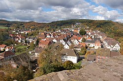
Polle is a municipality in the district of Holzminden, in Lower Saxony, Germany. It is situated on the river Weser, approx. 8 km northwest of Holzminden.

References

  1. ^ "LSN-Online Regionaldatenbank, Tabelle A100001G: Fortschreibung des Bevölkerungsstandes, Stand 31. Dezember 2022" (in German). Landesamt für Statistik Niedersachsen.


polle Latitude and Longitude:

51°54′N 9°24′E / 51.900°N 9.400°E / 51.900; 9.400
From Wikipedia, the free encyclopedia
Polle
Polle
Polle
Coat of arms of Polle
Location of Polle within Holzminden district
Holzminden (district) Lower Saxony Hesse North Rhine-Westphalia Hamelin-Pyrmont Hildesheim (district) Northeim (district) Lauenförde Derental Fürstenberg Boffzen Holzminden Heinade Heinsen Bevern Deensen Wangelnstedt Eimen Stadtoldendorf Lenne Arholzen Polle Vahlbruch Ottenstein Brevörde Hehlen Negenborn Golmbach Holenberg Heyen Halle Dielmissen Bodenwerder Pegestorf Kirchbrak Lüerdissen Eschershausen Holzen Delligsen Boffzen (unincorporated area) Unincorporated area in Holzminden district
Polle is located in Germany
Polle
Polle
Polle is located in Lower Saxony
Polle
Polle
Coordinates: 51°54′N 9°24′E / 51.900°N 9.400°E / 51.900; 9.400
Country Germany
State Lower Saxony
District Holzminden
Municipal assoc. Bodenwerder-Polle
Government
 •  MayorHans Alexander Meinders ( SPD)
Area
 • Total21.2 km2 (8.2 sq mi)
Elevation
90 m (300 ft)
Population
 (2022-12-31) [1]
 • Total1,137
 • Density54/km2 (140/sq mi)
Time zone UTC+01:00 ( CET)
 • Summer ( DST) UTC+02:00 ( CEST)
Postal codes
37647
Dialling codes05535
Vehicle registrationHOL
Website www.polle-weser.de

Polle is a municipality in the district of Holzminden, in Lower Saxony, Germany. It is situated on the river Weser, approx. 8 km northwest of Holzminden.

References

  1. ^ "LSN-Online Regionaldatenbank, Tabelle A100001G: Fortschreibung des Bevölkerungsstandes, Stand 31. Dezember 2022" (in German). Landesamt für Statistik Niedersachsen.


Videos

Youtube | Vimeo | Bing

Websites

Google | Yahoo | Bing

Encyclopedia

Google | Yahoo | Bing

Facebook