Podgórz | |
|---|---|
District of
Toruń | |
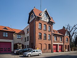
 Fire station in Podgórz | |
 Location of Podgórz within Toruń | |
| Coordinates: 52°59′16″N 18°35′16″E / 52.98778°N 18.58778°E | |
| Country | |
| Voivodeship | Kuyavian-Pomeranian |
| County/City | Toruń |
| Within city limits | 1938 |
| Time zone | UTC+1 ( CET) |
| • Summer ( DST) | UTC+2 ( CEST) |
| Vehicle registration | CT |
Podgórz [ˈpɔdɡuʂ] is a district of Toruń, Poland, [1] located in the southern part of the city, within its part located in the historic region of Kuyavia.
History

Podgórz was a royal town of the Kingdom of Poland, administratively located in the Inowrocław County in the Inowrocław Voivodeship in the Greater Poland Province. [2] In 1644, the Franciscans moved from Toruń to Podgórz, and castellan of Bydgoszcz and starost of Dybów Stanisław Sokołowski funded the construction of a monastery. [3] After the annexation of Inowrocław by Prussia in 1773, the county seat of the Inowrocław County was moved to Podgórz in 1776. [3] In 1813, the town was devastated by French troops. [3]
In 1934, the adjacent settlement of Piaski was included within the town limits of Podgórz. [4] In 1938, Podgórz was included within the city limits of Toruń, as its left-bank district. [5]
References
- ^ Rozporządzenie Ministra Administracji i Cyfryzacji z dnia 13 grudnia 2012 r. w sprawie wykazu urzędowych nazw miejscowości i ich części, Dz. U. z 2013 r. poz. 200
- ^ Atlas historyczny Polski. Kujawy i ziemia dobrzyńska w drugiej połowie XVI wieku. Część I. Mapy, plany (in Polish). Warszawa: Instytut Historii Polskiej Akademii Nauk. 2021. p. 1.
- ^
a
b
c Słownik geograficzny Królestwa Polskiego i innych krajów słowiańskich, Tom VIII (in Polish). Warszawa. 1887. p. 381.
{{
cite book}}
: CS1 maint: location missing publisher ( link) - ^ Rozporządzenie Ministra Sprawiedliwości z dnia 25 czerwca 1934 r. o zmianie granic miasta Podgórz w powiecie toruńskim, województwie pomorskiem., Dz. U. z 1934 r. Nr 56, poz. 500
- ^ Ustawa z dnia 8 kwietnia 1937 r. o zniesieniu miasta Podgórza w powiecie toruńskim, województwa pomorskiego i włączeniu go do miasta Torunia w tymże województwie., Dz. U. z 1937 r. Nr 29, poz. 217
Podgórz | |
|---|---|
District of
Toruń | |
 Fire station in Podgórz | |
 Location of Podgórz within Toruń | |
| Coordinates: 52°59′16″N 18°35′16″E / 52.98778°N 18.58778°E | |
| Country | |
| Voivodeship | Kuyavian-Pomeranian |
| County/City | Toruń |
| Within city limits | 1938 |
| Time zone | UTC+1 ( CET) |
| • Summer ( DST) | UTC+2 ( CEST) |
| Vehicle registration | CT |
Podgórz [ˈpɔdɡuʂ] is a district of Toruń, Poland, [1] located in the southern part of the city, within its part located in the historic region of Kuyavia.
History

Podgórz was a royal town of the Kingdom of Poland, administratively located in the Inowrocław County in the Inowrocław Voivodeship in the Greater Poland Province. [2] In 1644, the Franciscans moved from Toruń to Podgórz, and castellan of Bydgoszcz and starost of Dybów Stanisław Sokołowski funded the construction of a monastery. [3] After the annexation of Inowrocław by Prussia in 1773, the county seat of the Inowrocław County was moved to Podgórz in 1776. [3] In 1813, the town was devastated by French troops. [3]
In 1934, the adjacent settlement of Piaski was included within the town limits of Podgórz. [4] In 1938, Podgórz was included within the city limits of Toruń, as its left-bank district. [5]
References
- ^ Rozporządzenie Ministra Administracji i Cyfryzacji z dnia 13 grudnia 2012 r. w sprawie wykazu urzędowych nazw miejscowości i ich części, Dz. U. z 2013 r. poz. 200
- ^ Atlas historyczny Polski. Kujawy i ziemia dobrzyńska w drugiej połowie XVI wieku. Część I. Mapy, plany (in Polish). Warszawa: Instytut Historii Polskiej Akademii Nauk. 2021. p. 1.
- ^
a
b
c Słownik geograficzny Królestwa Polskiego i innych krajów słowiańskich, Tom VIII (in Polish). Warszawa. 1887. p. 381.
{{
cite book}}
: CS1 maint: location missing publisher ( link) - ^ Rozporządzenie Ministra Sprawiedliwości z dnia 25 czerwca 1934 r. o zmianie granic miasta Podgórz w powiecie toruńskim, województwie pomorskiem., Dz. U. z 1934 r. Nr 56, poz. 500
- ^ Ustawa z dnia 8 kwietnia 1937 r. o zniesieniu miasta Podgórza w powiecie toruńskim, województwa pomorskiego i włączeniu go do miasta Torunia w tymże województwie., Dz. U. z 1937 r. Nr 29, poz. 217
