Photos • Location
| Planachaux | |
|---|---|
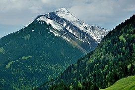
 View from the east | |
| Highest point | |
| Elevation | 1,925 m (6,316 ft) |
| Prominence | 287 m (942 ft) [1] |
| Parent peak | Dent de Corjon |
| Coordinates | 46°26′39″N 07°03′17″E / 46.44417°N 7.05472°E |
| Geography | |
| Location | Vaud, Switzerland |
| Parent range | Swiss Prealps |
The Planachaux (1,925 metres (6,316 ft)) is a mountain of the Swiss Prealps, located south of Rossinière in the canton of Vaud. It overlooks the Lac de l'Hongrin on its south side.
| Planachaux | |
|---|---|
 View from the east | |
| Highest point | |
| Elevation | 1,925 m (6,316 ft) |
| Prominence | 287 m (942 ft) [1] |
| Parent peak | Dent de Corjon |
| Coordinates | 46°26′39″N 07°03′17″E / 46.44417°N 7.05472°E |
| Geography | |
| Location | Vaud, Switzerland |
| Parent range | Swiss Prealps |
The Planachaux (1,925 metres (6,316 ft)) is a mountain of the Swiss Prealps, located south of Rossinière in the canton of Vaud. It overlooks the Lac de l'Hongrin on its south side.
