Photos • Location
| Piz Por | |
|---|---|
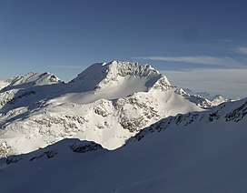
 View from the
Surettahorn (west side) | |
| Highest point | |
| Elevation | 3,028 m (9,934 ft) |
| Prominence | 733 m (2,405 ft) [1] |
| Parent peak | Piz Platta |
| Listing | Alpine mountains above 3000 m |
| Coordinates | 46°30′33.9″N 9°23′3.2″E / 46.509417°N 9.384222°E |
| Geography | |
| Location | Graubünden, Switzerland |
| Parent range | Oberhalbstein Range |
Piz Por (3,028 m) is a mountain of the Oberhalbstein Alps, located west of Innerferrera in the canton of Graubünden. It is the culminating point of the group between the Splügen Pass and the Niemet Pass.
References
External links
| Piz Por | |
|---|---|
 View from the
Surettahorn (west side) | |
| Highest point | |
| Elevation | 3,028 m (9,934 ft) |
| Prominence | 733 m (2,405 ft) [1] |
| Parent peak | Piz Platta |
| Listing | Alpine mountains above 3000 m |
| Coordinates | 46°30′33.9″N 9°23′3.2″E / 46.509417°N 9.384222°E |
| Geography | |
| Location | Graubünden, Switzerland |
| Parent range | Oberhalbstein Range |
Piz Por (3,028 m) is a mountain of the Oberhalbstein Alps, located west of Innerferrera in the canton of Graubünden. It is the culminating point of the group between the Splügen Pass and the Niemet Pass.
References
External links
