แร่หมื่นล้าน บ้านกลางน้ำ ถ้ำงามตา ภูผาแปลก แมกไม้จำปูน บริบูรณ์ด้วยทรัพยากร ("Millions of minerals. Home in the water. Beautiful caves and weird cliffs. Branches of the Anaxagorea. Rich in resources.")
The province, located on the western side of the
Malay Peninsula, encompasses the islands within
Phang Nga Bay. Among these,
Khao Phing Kan and Ko Ta Pu, often referred to as "James Bond Island," gained prominence following their appearance in the 1974 film The Man with the Golden Gun. In this film, Khao Phing Kan serves as the base for the antagonist, with the distinct, needle-shaped
limestone formation of Ko Ta Pu, situated approximately 20 metres (22 yd) off the main beach, featuring significantly. To safeguard these and other islands, the
Ao Phang Nga (Phang Nga Bay) National Park was established in 1981.[6] The province also includes the
Similan Islands and
Surin Islands, notable diving destinations in Thailand.[7] The total forested area of the province is approximately 1,778 km2 (686 sq mi), accounting for 32.4 percent of its total area.[8]
Toponymy
Phang Nga derives its name from the ancient Malay term "Pangan," which translates to '
jungle' in contemporary Thai. This term historically referred to a broad category of indigenous peoples, colloquially known as 'orang Pangan' in Malay. This phrase was used to describe communities perceived as 'heathen, pagan, or primitive', typically residing in the dense jungle regions of the Malay Peninsula[9] and its adjacent islands.
History
During the reign of
King Rama II, the region surrounding Thalang (currently known as
Phuket) fell under
Burmese occupation, leading to a significant influx of refugees into Kraphu Nga. Following the successful expulsion of Burmese forces by
Siamese troops in 1824, King Rama III renamed the area adjacent to the bay as Phang Nga. This adaptation from the Malay word "pangan" suggests the historical presence of Orang Asli or other indigenous groups in the region. In 1933, the town was elevated to the status of a province.
On the morning of 26 December 2004, the Andaman Sea coastline of Phang Nga Province experienced severe devastation due to a
tsunami, resulting in extensive loss of life.
Khura Buri District, and particularly Ko Phra Thong, referred to as smuggler's paradise, has been identified as a critical point of entry for illegal activities in Thailand, including human trafficking. This area is reportedly a transit route for various groups, including
Rohingya,
Uighur, and Syrian refugees seeking entry into Thailand.[10]
The
official seal of the province features an illustration of the
Phu Khao Chang mountains, set as a backdrop to the depiction of the city hall. Additionally, the seal includes an image of a dredge, symbolizing the province's history of
tin mining.[11]
The provincial slogan encapsulates various aspects of the region's identity and heritage: "Massive mining industry, Ban Klang Nam 'floating house', delightful caves, strangely shaped hills, Jampun flower, rich in resources". This slogan reflects the diverse elements that define the province, from its industrial past to its unique natural and cultural features.[11]
In terms of regional flora, the province has designated
Cinnamomum porrectum, commonly known as hardy cinnamon, as its
official tree. The provincial flower is
Anaxagorea javanica, further emphasizing the area's rich botanical diversity.
Administrative divisions
Map of eight districts
Provincial government
Phang Nga is divided into eight districts (amphoes), which are further divided into 48 subdistricts (tambons) and 314 villages (mubans).
As of 26 November 2019, there are:[12] one Phang Nga Provincial Administration Organisation (ongkan borihan suan changwat) and 15 municipal (thesaban) areas in the province. Phang Nga and Takua Pa have town (thesaban mueang) status. Further 13 subdistrict municipalities (thesaban tambon). The non-municipal areas are administered by 36 Subdistrict Administrative Organisations - SAO (ongkan borihan suan tambon).[3]
Transportation
Transportation in Phang Nga Province is primarily facilitated through a network of highways.
Roads: Highway 4 is the main artery connecting most districts within the province, excluding Kapong and Ko Yao. Highway 401 provides a route to Surat Thani, while Highway 402 links Phang Nga with Phuket Province. Additionally, Highway 4090 connects Muang to Kapong District.
Bus: These services in the province offer frequent connections to Bangkok and other regions. Intra-provincial travel is supported by non-air-conditioned buses.
Public transit:Songthaews are the predominant form of public transit within Phang Nga, offering accessible transportation options to the local population.
Motorbike-taxi: They are primarily found in Phang Nga town, cater to short-distance travel, with fares varying based on distance.
Airport: As of now, Phang Nga Province does not have an airport. The nearest facility is
Phuket International Airport. Plans for a new airport in
Phang Nga have been proposed, with the intention of serving not only Phang Nga but also neighboring Krabi Province and as an alternative to Phuket's existing airport.[13][14]
Human achievement index 2022
Health
Education
Employment
Income
21
41
77
24
Housing
Family
Transport
Participation
41
60
12
10
Province Phang Nga, with an HAI 2022 value of 0.6432 is "average", and occupies place 36 in the ranking.
Since 2003, United Nations Development Programme (UNDP) in Thailand has tracked progress on human development at the sub-national level using the
Human achievement index (HAI), a composite index covering all the eight key areas of human development. The National Economic and Social Development Board (NESDB) has taken over this task since 2017.[4]
Rank
Classification
1 - 13
"high"
14 - 29
"somewhat high"
30 - 45
"average"
46 - 61
"somewhat low"
62 - 77
"low"
Map with provinces and HAI 2022 rankings
National parks
Region 5 (Nakhon Si Thammarat) of Thailand's protected areas encompasses a total of twenty national parks, six of which are particularly notable. These parks are characterized by their diverse ecological landscapes and natural features. The region, renowned for its environmental variety, includes parks that range from coastal and marine environments to mountainous and forested areas. Each park serves as a habitat for a variety of flora and fauna.
Ao Phang Nga (Phang Nga Bay) National Park (อุทยานแห่งชาติอ่าวพังงา), officially designated on 29 April 1981, spans an area of approximately 400 square kilometers (150 sq mi), equivalent to 250,000 rai.[15]: 25 This park is distinguished by its picturesque landscapes, notably featuring a multitude of limestone formations rising majestically from the sea near the coast. These geological structures also account for the high concentration of caves within the park's boundaries. The area is rich in mangrove forests, contributing to its ecological diversity. Additionally, the park encompasses several islands, each contributing to the overall scenic and biological richness of Ao Phang Nga National Park.
Mu Ko Surin National Park (อุทยานแห่งชาติหมู่เกาะสุรินทร์), formally established on 9 July 1981, encompasses an archipelago consisting of five islands: Ko Surin Nuea, Ko Surin Tai, Ko Ri, Ko Khai, and Ko Klang.[16] The park covers an area of approximately 141 square kilometers (54 sq mi), equivalent to 88,282 rai.[15]: 30 Located in the Andaman Sea, close to the maritime border between Thailand and Myanmar, the archipelago is known for its rich marine life and coral reefs.
Si Phang Nga National Park (อุทยานแห่งชาติศรีพังงา), designated as a national park on 16 April 1988, spans an area of about 246 square kilometers (95 sq mi) or 153,800 rai. The park's landscape is characterized by its rugged mountainous terrain, predominantly covered with dipterocarp forests. These natural features contribute to the park's biodiversity and its status as a significant ecological area.
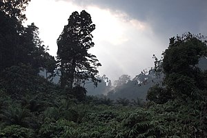
Khao Lak–Lam Ru National Park (อุทยานแห่งชาติเขาหลัก-ลำรู่) was established on 30 August 1991, encompassing an area of approximately 125 square kilometers (48 sq mi)[15]: 66 or 78,125 rai. The park extends across Thai Mueang, Kapong, Takua Pa, and Mueang Districts. Notable sites within the park include Khao Lak, home to the Chao Pho Khao Lak Shrine, Laem Pakarang, known for its pine groves and suitability for camping and relaxation, and the Ton Chong Fa Waterfall (Namtok Ton Chong Fa).[17]
Khao Lampi–Hat Thai Mueang National Park (อุทยานแห่งชาติเขาลำปี-หาดท้ายเหมือง), designated on 14 April 1988, covers about 72 square kilometers (28 sq mi),[15]: 52 or 44,950 rai. Key attractions in the park are the year-round Namtok Lampi, a 6-tiered waterfall; Namtok Ton Phrai, another perennial waterfall; and Hat Thai Mueang beach, the annual site of the Sea Turtle Festival.[18]
Khao Lak-Lam Ru jungle.
Mu Ko Similan National Park (อุทยานแห่งชาติหมู่เกาะสิมิลัน) was declared a national park on 1 September 1982. The park, spanning around 140 square kilometers (54 sq mi)[15]: 43 or 87,500 rai, consists of the Similan Islands, a group of nine islands. The park is closed annually from 16 May to 31 October for ecological recovery and maintenance.[19]
There is one wildlife sanctuary, along with three other wildlife sanctuaries, makeup
region 5 (Nakhon Si Thammarat) of Thailand's protected areas.
Namtok Song Phraek Wildlife Sanctuary occupies an area of 138,712 rai ~ 222 square kilometers (86 sq mi).[20]: 8 The wildlife sanctuary was previously known as Ton Pariwat wildlife sanctuary and covers Kapong district, Mueang Phang Nga district, and Thap Put district.
Gallery
Dusty road around Phang Nga town
Northern entrance to Phang Nga Bay
Mu Ko Similan National Park
Limestone islets in Phangnga Bay
Limestone islets in Phangnga Bay, Ao Phangnga National Park
^"ประกาศสำนักนายกรัฐมนตรี เรื่อง แต่งตั้งข้าราชการพลเรือนสามัญ" [Announcement of the Prime Minister's Office regarding the appointment of civil servants] (PDF). Royal Thai Government Gazette. 136 (Special 242 Ngor). 15. 28 September 2019. Archived from
the original(PDF) on 29 September 2019. Retrieved 24 November 2019.
^
ab"รายงานสถิติจำนวนประชากรและบ้านประจำปี พ.ศ.2561" [Statistics, population and house statistics for the year 2018]. Registration Office Department of the Interior, Ministry of the Interior (in Thai). 31 December 2018. Archived from
the original on 14 June 2019. Retrieved 20 June 2019.
^
ab"ข้อมูลสถิติดัชนีความก้าวหน้าของคน ปี 2565 (PDF)" [Human Achievement Index Databook year 2022 (PDF)]. Office of the National Economic and Social Development Council (NESDC) (in Thai). Retrieved 12 March 2024, page 48{{
cite web}}: CS1 maint: postscript (
link)
^"About Phang Nga". Tourism Authority of Thailand (TAT). Archived from
the original on 22 April 2019. Retrieved 16 December 2018.
^"ตารางที่ 2 พี้นที่ป่าไม้ แยกรายจังหวัด พ.ศ.2562" [Table 2 Forest area Separate province year 2019]. Royal Forest Department (in Thai). 2019.
Archived from the original on 10 April 2021. Retrieved 6 April 2021, information, Forest statistics Year 2019{{
cite web}}: CS1 maint: postscript (
link)
^Mid 19th century; earliest use found in Thomas Newbold (1807–1850), an army officer in the East India Company and oriental scholar. Malay: Pangan, a tract of forest (Oxford Dictionaries).
^Yongcharoenchai, Chaiyot; Na Thalang, Jeerawat (20 September 2015).
"Tied up in a trafficking jam". Bangkok Post.
Archived from the original on 1 May 2023. Retrieved 20 September 2015.
^
ab"Symbol of Phang Nga". OSM Andamnan: The Office of Strategy Management for Southern Province Cluster.
Archived from the original on 26 May 2015. Retrieved 26 May 2015.
^"Number of local government organizations by province". dla.go.th. Department of Local Administration (DLA). 26 November 2019.
Archived from the original on 26 November 2019. Retrieved 10 December 2019. 33 Phang Nga: 1 PAO, 2 Town mun., 13 Subdistrict mun., 36 SAO.
^
abcde.
"ข้อมูลพื้นที่อุทยานแห่งชาติ ที่ประกาศในราชกิจจานุบกษา 133 แห่ง" [National Park Area Information published in the 133 Government Gazettes]. Department of National Parks, Wildlife and Plant Conservation (in Thai). December 2020.
Archived from the original on 3 November 2022. Retrieved 1 November 2022.
^"ตาราง 5 พื้นที่เขตรักษาพันธุ์สัตว์ป่า พ.ศ. 2562" [Table 5 Wildlife Sanctuary Areas in 2019] (PDF). Department of National Parks, Wildlife Sanctuaries and Plant Conservation (in Thai). 2019.
Archived(PDF) from the original on 16 November 2022. Retrieved 1 November 2022.
แร่หมื่นล้าน บ้านกลางน้ำ ถ้ำงามตา ภูผาแปลก แมกไม้จำปูน บริบูรณ์ด้วยทรัพยากร ("Millions of minerals. Home in the water. Beautiful caves and weird cliffs. Branches of the Anaxagorea. Rich in resources.")
The province, located on the western side of the
Malay Peninsula, encompasses the islands within
Phang Nga Bay. Among these,
Khao Phing Kan and Ko Ta Pu, often referred to as "James Bond Island," gained prominence following their appearance in the 1974 film The Man with the Golden Gun. In this film, Khao Phing Kan serves as the base for the antagonist, with the distinct, needle-shaped
limestone formation of Ko Ta Pu, situated approximately 20 metres (22 yd) off the main beach, featuring significantly. To safeguard these and other islands, the
Ao Phang Nga (Phang Nga Bay) National Park was established in 1981.[6] The province also includes the
Similan Islands and
Surin Islands, notable diving destinations in Thailand.[7] The total forested area of the province is approximately 1,778 km2 (686 sq mi), accounting for 32.4 percent of its total area.[8]
Toponymy
Phang Nga derives its name from the ancient Malay term "Pangan," which translates to '
jungle' in contemporary Thai. This term historically referred to a broad category of indigenous peoples, colloquially known as 'orang Pangan' in Malay. This phrase was used to describe communities perceived as 'heathen, pagan, or primitive', typically residing in the dense jungle regions of the Malay Peninsula[9] and its adjacent islands.
History
During the reign of
King Rama II, the region surrounding Thalang (currently known as
Phuket) fell under
Burmese occupation, leading to a significant influx of refugees into Kraphu Nga. Following the successful expulsion of Burmese forces by
Siamese troops in 1824, King Rama III renamed the area adjacent to the bay as Phang Nga. This adaptation from the Malay word "pangan" suggests the historical presence of Orang Asli or other indigenous groups in the region. In 1933, the town was elevated to the status of a province.
On the morning of 26 December 2004, the Andaman Sea coastline of Phang Nga Province experienced severe devastation due to a
tsunami, resulting in extensive loss of life.
Khura Buri District, and particularly Ko Phra Thong, referred to as smuggler's paradise, has been identified as a critical point of entry for illegal activities in Thailand, including human trafficking. This area is reportedly a transit route for various groups, including
Rohingya,
Uighur, and Syrian refugees seeking entry into Thailand.[10]
The
official seal of the province features an illustration of the
Phu Khao Chang mountains, set as a backdrop to the depiction of the city hall. Additionally, the seal includes an image of a dredge, symbolizing the province's history of
tin mining.[11]
The provincial slogan encapsulates various aspects of the region's identity and heritage: "Massive mining industry, Ban Klang Nam 'floating house', delightful caves, strangely shaped hills, Jampun flower, rich in resources". This slogan reflects the diverse elements that define the province, from its industrial past to its unique natural and cultural features.[11]
In terms of regional flora, the province has designated
Cinnamomum porrectum, commonly known as hardy cinnamon, as its
official tree. The provincial flower is
Anaxagorea javanica, further emphasizing the area's rich botanical diversity.
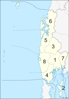
Administrative divisions
Map of eight districts
Provincial government
Phang Nga is divided into eight districts (amphoes), which are further divided into 48 subdistricts (tambons) and 314 villages (mubans).
As of 26 November 2019, there are:[12] one Phang Nga Provincial Administration Organisation (ongkan borihan suan changwat) and 15 municipal (thesaban) areas in the province. Phang Nga and Takua Pa have town (thesaban mueang) status. Further 13 subdistrict municipalities (thesaban tambon). The non-municipal areas are administered by 36 Subdistrict Administrative Organisations - SAO (ongkan borihan suan tambon).[3]
Transportation
Transportation in Phang Nga Province is primarily facilitated through a network of highways.
Roads: Highway 4 is the main artery connecting most districts within the province, excluding Kapong and Ko Yao. Highway 401 provides a route to Surat Thani, while Highway 402 links Phang Nga with Phuket Province. Additionally, Highway 4090 connects Muang to Kapong District.
Bus: These services in the province offer frequent connections to Bangkok and other regions. Intra-provincial travel is supported by non-air-conditioned buses.
Public transit:Songthaews are the predominant form of public transit within Phang Nga, offering accessible transportation options to the local population.
Motorbike-taxi: They are primarily found in Phang Nga town, cater to short-distance travel, with fares varying based on distance.
Airport: As of now, Phang Nga Province does not have an airport. The nearest facility is
Phuket International Airport. Plans for a new airport in
Phang Nga have been proposed, with the intention of serving not only Phang Nga but also neighboring Krabi Province and as an alternative to Phuket's existing airport.[13][14]
Human achievement index 2022
Health
Education
Employment
Income
21
41
77
24
Housing
Family
Transport
Participation
41
60
12
10
Province Phang Nga, with an HAI 2022 value of 0.6432 is "average", and occupies place 36 in the ranking.
Since 2003, United Nations Development Programme (UNDP) in Thailand has tracked progress on human development at the sub-national level using the
Human achievement index (HAI), a composite index covering all the eight key areas of human development. The National Economic and Social Development Board (NESDB) has taken over this task since 2017.[4]
Rank
Classification
1 - 13
"high"
14 - 29
"somewhat high"
30 - 45
"average"
46 - 61
"somewhat low"
62 - 77
"low"
Map with provinces and HAI 2022 rankings
National parks
Region 5 (Nakhon Si Thammarat) of Thailand's protected areas encompasses a total of twenty national parks, six of which are particularly notable. These parks are characterized by their diverse ecological landscapes and natural features. The region, renowned for its environmental variety, includes parks that range from coastal and marine environments to mountainous and forested areas. Each park serves as a habitat for a variety of flora and fauna.
Ao Phang Nga (Phang Nga Bay) National Park (อุทยานแห่งชาติอ่าวพังงา), officially designated on 29 April 1981, spans an area of approximately 400 square kilometers (150 sq mi), equivalent to 250,000 rai.[15]: 25 This park is distinguished by its picturesque landscapes, notably featuring a multitude of limestone formations rising majestically from the sea near the coast. These geological structures also account for the high concentration of caves within the park's boundaries. The area is rich in mangrove forests, contributing to its ecological diversity. Additionally, the park encompasses several islands, each contributing to the overall scenic and biological richness of Ao Phang Nga National Park.
Mu Ko Surin National Park (อุทยานแห่งชาติหมู่เกาะสุรินทร์), formally established on 9 July 1981, encompasses an archipelago consisting of five islands: Ko Surin Nuea, Ko Surin Tai, Ko Ri, Ko Khai, and Ko Klang.[16] The park covers an area of approximately 141 square kilometers (54 sq mi), equivalent to 88,282 rai.[15]: 30 Located in the Andaman Sea, close to the maritime border between Thailand and Myanmar, the archipelago is known for its rich marine life and coral reefs.
Si Phang Nga National Park (อุทยานแห่งชาติศรีพังงา), designated as a national park on 16 April 1988, spans an area of about 246 square kilometers (95 sq mi) or 153,800 rai. The park's landscape is characterized by its rugged mountainous terrain, predominantly covered with dipterocarp forests. These natural features contribute to the park's biodiversity and its status as a significant ecological area.
Khao Lak–Lam Ru National Park (อุทยานแห่งชาติเขาหลัก-ลำรู่) was established on 30 August 1991, encompassing an area of approximately 125 square kilometers (48 sq mi)[15]: 66 or 78,125 rai. The park extends across Thai Mueang, Kapong, Takua Pa, and Mueang Districts. Notable sites within the park include Khao Lak, home to the Chao Pho Khao Lak Shrine, Laem Pakarang, known for its pine groves and suitability for camping and relaxation, and the Ton Chong Fa Waterfall (Namtok Ton Chong Fa).[17]
Khao Lampi–Hat Thai Mueang National Park (อุทยานแห่งชาติเขาลำปี-หาดท้ายเหมือง), designated on 14 April 1988, covers about 72 square kilometers (28 sq mi),[15]: 52 or 44,950 rai. Key attractions in the park are the year-round Namtok Lampi, a 6-tiered waterfall; Namtok Ton Phrai, another perennial waterfall; and Hat Thai Mueang beach, the annual site of the Sea Turtle Festival.[18]
Khao Lak-Lam Ru jungle.
Mu Ko Similan National Park (อุทยานแห่งชาติหมู่เกาะสิมิลัน) was declared a national park on 1 September 1982. The park, spanning around 140 square kilometers (54 sq mi)[15]: 43 or 87,500 rai, consists of the Similan Islands, a group of nine islands. The park is closed annually from 16 May to 31 October for ecological recovery and maintenance.[19]
There is one wildlife sanctuary, along with three other wildlife sanctuaries, makeup
region 5 (Nakhon Si Thammarat) of Thailand's protected areas.
Namtok Song Phraek Wildlife Sanctuary occupies an area of 138,712 rai ~ 222 square kilometers (86 sq mi).[20]: 8 The wildlife sanctuary was previously known as Ton Pariwat wildlife sanctuary and covers Kapong district, Mueang Phang Nga district, and Thap Put district.
Gallery
Dusty road around Phang Nga town
Northern entrance to Phang Nga Bay
Mu Ko Similan National Park
Limestone islets in Phangnga Bay
Limestone islets in Phangnga Bay, Ao Phangnga National Park
^"ประกาศสำนักนายกรัฐมนตรี เรื่อง แต่งตั้งข้าราชการพลเรือนสามัญ" [Announcement of the Prime Minister's Office regarding the appointment of civil servants] (PDF). Royal Thai Government Gazette. 136 (Special 242 Ngor). 15. 28 September 2019. Archived from
the original(PDF) on 29 September 2019. Retrieved 24 November 2019.
^
ab"รายงานสถิติจำนวนประชากรและบ้านประจำปี พ.ศ.2561" [Statistics, population and house statistics for the year 2018]. Registration Office Department of the Interior, Ministry of the Interior (in Thai). 31 December 2018. Archived from
the original on 14 June 2019. Retrieved 20 June 2019.
^
ab"ข้อมูลสถิติดัชนีความก้าวหน้าของคน ปี 2565 (PDF)" [Human Achievement Index Databook year 2022 (PDF)]. Office of the National Economic and Social Development Council (NESDC) (in Thai). Retrieved 12 March 2024, page 48{{
cite web}}: CS1 maint: postscript (
link)
^"About Phang Nga". Tourism Authority of Thailand (TAT). Archived from
the original on 22 April 2019. Retrieved 16 December 2018.
^"ตารางที่ 2 พี้นที่ป่าไม้ แยกรายจังหวัด พ.ศ.2562" [Table 2 Forest area Separate province year 2019]. Royal Forest Department (in Thai). 2019.
Archived from the original on 10 April 2021. Retrieved 6 April 2021, information, Forest statistics Year 2019{{
cite web}}: CS1 maint: postscript (
link)
^Mid 19th century; earliest use found in Thomas Newbold (1807–1850), an army officer in the East India Company and oriental scholar. Malay: Pangan, a tract of forest (Oxford Dictionaries).
^Yongcharoenchai, Chaiyot; Na Thalang, Jeerawat (20 September 2015).
"Tied up in a trafficking jam". Bangkok Post.
Archived from the original on 1 May 2023. Retrieved 20 September 2015.
^
ab"Symbol of Phang Nga". OSM Andamnan: The Office of Strategy Management for Southern Province Cluster.
Archived from the original on 26 May 2015. Retrieved 26 May 2015.
^"Number of local government organizations by province". dla.go.th. Department of Local Administration (DLA). 26 November 2019.
Archived from the original on 26 November 2019. Retrieved 10 December 2019. 33 Phang Nga: 1 PAO, 2 Town mun., 13 Subdistrict mun., 36 SAO.
^
abcde.
"ข้อมูลพื้นที่อุทยานแห่งชาติ ที่ประกาศในราชกิจจานุบกษา 133 แห่ง" [National Park Area Information published in the 133 Government Gazettes]. Department of National Parks, Wildlife and Plant Conservation (in Thai). December 2020.
Archived from the original on 3 November 2022. Retrieved 1 November 2022.
^"ตาราง 5 พื้นที่เขตรักษาพันธุ์สัตว์ป่า พ.ศ. 2562" [Table 5 Wildlife Sanctuary Areas in 2019] (PDF). Department of National Parks, Wildlife Sanctuaries and Plant Conservation (in Thai). 2019.
Archived(PDF) from the original on 16 November 2022. Retrieved 1 November 2022.

 Phang-nga National Park
 Limestone islets in Phang-nga National Park
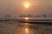 Sunset in Phang Nga Bay
 Karst formations


.png)


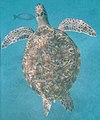 Turtle at Similan
 Whale shark at Similan
 Phantom Bannerfish at Similan


 Dusty road around Phang Nga town
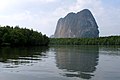 Northern entrance to Phang Nga Bay
 Mu Ko Similan National Park
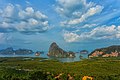 Limestone islets in Phangnga Bay
 Limestone islets in Phangnga Bay, Ao Phangnga National Park
 Emerald lagoon in Phang Nga Bay
 Cardisoma carnifex at Similan Islands
 Khao Lampi–Hat Thai Mueang National Park
 View from Similan Island to Andaman Sea
 Mai-Ngam beach, Surin Islands National Park
 Khao Lak–Lam Ru National Park


 Phang Nga travel guide from Wikivoyage