Photos • Location
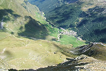
Pfelders and the Pfelderer Tal seen from the path to the
Zwickauer Hütte


The Pfelderer Tal, also Pfelderstal ( Italian: Val di Plan; German: Pfelderer Tal), is a side valley of the Passeier Valley in South Tyrol, Italy.
References
- Alpenverein South Tyrol (in German)
External links
![]() Media related to
Pfelderer Tal at Wikimedia Commons
Media related to
Pfelderer Tal at Wikimedia Commons
46°48′13″N 11°6′53″E / 46.80361°N 11.11472°E
|
| This Trentino-Alto Adige/Südtirol location article is a stub. You can help Wikipedia by expanding it. |