Photos • Location

Peterson, Kansas | |
|---|---|
 | |
 Peterson  Peterson | |
| Coordinates: 38°01′57″N 101°04′02″W / 38.03250°N 101.06722°W [1] | |
| Country | United States |
| State | Kansas |
| County | Finney |
| Elevation | 2,969 ft (905 m) |
| Time zone | UTC-6 ( CST) |
| • Summer ( DST) | UTC-5 (CDT) |
| Area code | 620 |
| FIPS code | 20-55575 [1] |
| GNIS ID | 484569 [1] |
Peterson is an unincorporated community in Finney County, Kansas, United States. [1] It is 5 miles (8.0 km) northwest of Holcomb.
References
Further reading
External links
Municipalities and communities of
Finney County, Kansas, United States | ||
|---|---|---|
| Cities | 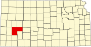 | |
| CDP | ||
|
Unincorporated communities | ||
| Ghost towns | ||
| Townships | ||
|
| This article about a location in Finney County, Kansas is a stub. You can help Wikipedia by expanding it. |
Peterson, Kansas | |
|---|---|
|
| |
Peterson Peterson | |
| Coordinates: 38°01′57″N 101°04′02″W / 38.03250°N 101.06722°W [1] | |
| Country | United States |
| State | Kansas |
| County | Finney |
| Elevation | 2,969 ft (905 m) |
| Time zone | UTC-6 ( CST) |
| • Summer ( DST) | UTC-5 (CDT) |
| Area code | 620 |
| FIPS code | 20-55575 [1] |
| GNIS ID | 484569 [1] |
Peterson is an unincorporated community in Finney County, Kansas, United States. [1] It is 5 miles (8.0 km) northwest of Holcomb.
References
Further reading
External links
Municipalities and communities of
Finney County, Kansas, United States | ||
|---|---|---|
| Cities | | |
| CDP | ||
|
Unincorporated communities | ||
| Ghost towns | ||
| Townships | ||
|
| This article about a location in Finney County, Kansas is a stub. You can help Wikipedia by expanding it. |